Automatic road identification method based on building general plane positioning map

An automatic identification and general plane technology, applied in character and pattern recognition, computer parts, calculation, etc., can solve problems such as difficult to accurately identify and extract roads, achieve the effect of speeding up calculation and realizing precise positioning

Pending Publication Date: 2022-02-01
长沙泛一参数信息技术有限公司
View PDF0 Cites 0 Cited by
  • Summary
  • Abstract
  • Description
  • Claims
  • Application Information

AI Technical Summary

Problems solved by technology

[0004] Based on the above problems, the present invention provides a method for automatic identification of roads based on the general building plan positioning map, which solves the problem that it is difficult to accurately identify and extract the graphic elements of the road from the general building plan positioning map and distinguish its types

Method used


Image

  • Automatic road identification method based on building general plane positioning map
  • Automatic road identification method based on building general plane positioning map
  • Automatic road identification method based on building general plane positioning map

Examples


Embodiment Construction

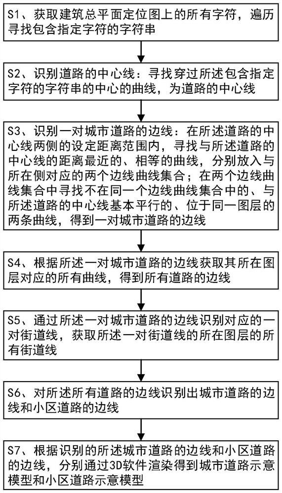
[0049] The specific implementation manners of the present invention will be further described in detail below in conjunction with the accompanying drawings and embodiments. The following examples are used to illustrate the present invention, but are not intended to limit the scope of the present invention.

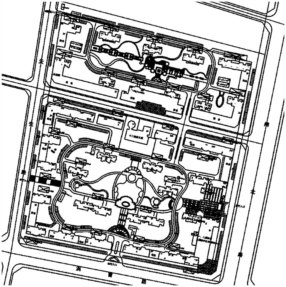
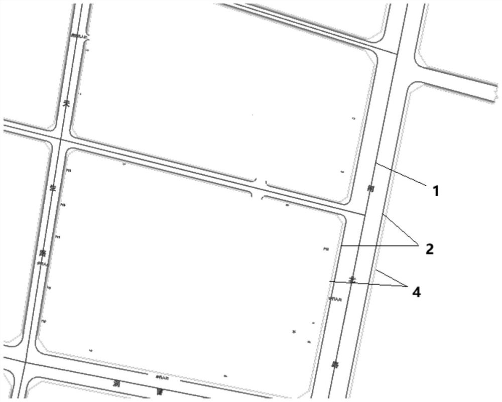
[0050] In order to realize the quick, batch, and digital modeling of the general building layout, it is necessary to identify and extract the plane graphics of various architectural objects and render them separately. The general layout of the building is as follows: figure 1As shown, the architectural objects included are very rich, including buildings, parking spaces, fire protection platforms, roads, landscapes, etc., and according to CAD drawing rules, each architectural object is drawn on at least one layer. When computer programming is used to recognize drawings, each building object cannot be directly recognized, only curves, characters, labels, etc., and their att...


PUM


Abstract

The invention discloses an automatic road identification method based on a building general plane positioning map, and the method comprises the steps: S1, obtaining all characters on the building general plane positioning map, and carrying out the traversing of a character string containing a specified character; S2, searching a curve passing through the center of the character string, the curve being the center line of the road; S3, searching two curves which are closest to and equal to the center line of the road, are basically parallel to the center line of the road and are located on the same layer for on the two sides of the center line of the road to obtain a pair of side lines of the urban road, the distance between the two curves and the center line of the road being within a set distance range; S4, obtaining all curves corresponding to the layers where the sidelines of the pair of urban roads are located, and obtaining the sidelines of all the roads; S5, identifying street lines; and S6, identifying the sidelines of the urban roads and the sidelines of the community roads from the sidelines of all the roads. According to the invention, the sidelines of the road are accurately identified and extracted from the building general plane positioning map and the road type is distinguished.

Description

technical field [0001] The invention relates to the technical field of architectural drawing object recognition, in particular to an automatic identification method for roads based on a building general plan positioning map. Background technique [0002] The core of BIM (Building Information Modeling) technology is to provide a complete and consistent construction engineering information library for this model by establishing a virtual three-dimensional model of construction engineering and using digital technology. The information base not only contains geometric information, professional attributes and state information describing building components, but also contains state information of non-component objects (such as space and motion behavior). With the help of this 3D model containing construction engineering information, the degree of information integration of construction engineering has been greatly improved, thus providing a platform for engineering information ex...

Claims


Application Information

Patent Timeline
Patent Type & Authority Applications(China)
IPC IPC(8): G06V30/422
Inventor 王虹张友三
Owner 长沙泛一参数信息技术有限公司
Why Eureka
Try Eureka