UAV Relative Pose Estimation Method for Fixed-point Landing Mark

A technology of relative pose and logo, applied in the field of UAV, can solve the problems such as the incomplete visual range of the logo, the inability to meet the practical needs of the mobile platform, and the limitation of the scope of application.

Active Publication Date: 2020-04-24
TSINGHUA UNIV
View PDF12 Cites 0 Cited by
  • Summary
  • Abstract
  • Description
  • Claims
  • Application Information

AI Technical Summary

Problems solved by technology

[0009] The method based on surface information generally assumes that the attitude of the UAV is close to the level, so the scope of application is limited
Moreover, since the sign cannot be fully displayed in the visual range when the drone lands at a lower position, the current method based on surface information cannot meet the practical needs on the mobile platform.

Method used


Image

  • UAV Relative Pose Estimation Method for Fixed-point Landing Mark
  • UAV Relative Pose Estimation Method for Fixed-point Landing Mark
  • UAV Relative Pose Estimation Method for Fixed-point Landing Mark

Examples


Embodiment Construction

[0070] In the drawings, the same or similar reference numerals are used to denote the same or similar elements or elements having the same or similar functions. Embodiments of the present invention will be described in detail below in conjunction with the accompanying drawings.

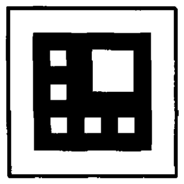
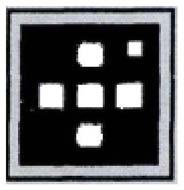
[0071]The UAV relative pose estimation method of the fixed-point landing sign is realized based on the image of the fixed-point landing sign (hereinafter referred to as "mark") collected by the UAV airborne camera as the information basis. Therefore, the shape design and detection method of the sign will directly affect the entire system. system performance. At present, most of the existing signs are placed on a fixed landing platform such as the ground, so the sign will not move, so the UAV airborne camera only needs to detect the sign within a period of time, and calculate the pose of the UAV relative to the sign platform information, and then land directly to the target point according to the calc...


PUM


Abstract

The present invention discloses a method for estimating a UAV relative pose for a fixed-point landing mark. The method comprises: step 1: designing the shape of a fixed-point landing mark on a mobileplatform, wherein the fixed-point landing mark adopts an RGB color model, and comprises an outer rectangular frame, an inner rectangular frame, and an isolated rectangular frame positioned between theouter rectangular frame and the inner rectangular frame and used for connecting the outer rectangular frame and the inner rectangular frame; step 2: detecting mark feature points based on vision; andstep 3: estimating the pose of a UAV relative to the fixed-point landing mark according to the detected mark feature points. The fixed-point landing mark of the mobile platform provided by the present invention is distinctly different from the existing landing marks in China and abroad in terms of shapes and recognition principles. The landing mark shape of the mobile platform, which combines aninner layer and an outer layer based on chromatics, enables the UAV to have mark features in an entire landing process, thereby providing a basis for autonomous landing on a fixed platform and the mobile platform.

Description

technical field [0001] The present invention relates to a UAV (English full name is "Unmanned Aerial Vehicle"; Chinese full name is "unmanned aircraft"; Chinese abbreviation is "UAV") autonomous navigation and landing technology field. UAV Relative Pose Estimation Method. Background technique [0002] Vision-based fixed-point landing marks are mainly used for autonomous navigation and landing of UAVs equipped with cameras. The UAV obtains the required feature information by detecting the pattern in the sign of the landing platform, and then uses the conversion relationship between the image coordinate system and the coordinates of the platform sign to solve the position and attitude of the UAV relative to the sign platform (hereinafter referred to as is "position") information, so as to realize UAV autonomous navigation and landing at a designated position. Compared with the characteristics of natural scenery and building facilities, fixed-point landing signs can provide i...

Claims


Application Information

Patent Timeline
Patent Type & Authority Patents(China)
IPC IPC(8): G01C21/00G01C11/00G01C11/04G06T7/11G06T7/13G06T7/73
CPCG01C11/00G01C11/04G01C21/005G06T7/11G06T7/13G06T7/73G06T2207/10024
Inventor 黄小云王建强许庆
Owner TSINGHUA UNIV
Why Eureka
Try Eureka