Three-dimensional modeling technology based on oblique photography assisted BIM and GIS

A technology of oblique photography and 3D modeling, applied in the field of 3D modeling, can solve problems such as inability to meet demand, and achieve the effect of high authenticity, high precision, and improving overall accuracy

Inactive Publication Date: 2019-08-16
TANGSHAN IND VOCATIONAL TECHN COLLEGE
View PDF5 Cites 54 Cited by
  • Summary
  • Abstract
  • Description
  • Claims
  • Application Information

AI Technical Summary

Benefits of technology

This patented describes an improved method for measuring elevation levels on surfaces that may be difficult or expensive to measure manually due to their shape. It uses images from different angles to create models without any errors caused by human factors such as shading or unevenness between areas. By adding these altitude controls at specific locations within each section of the surface, accurate measurements become easier than previously needed. Additionally, this technique allows users to see how things look inside them more clearly during construction process while also showing it's true state over time. Overall, this new approach improves the quality of buildings built using digital techniques like laser scanning (LSC).

Problems solved by technology

The technical problem addressed by this patented method is how to create accurate virtual reality (VR) worldwide with advanced tools like BIM for urban planning purposes while also utilizing obliquely photographed images collected through traditional techniques such as ground photosensors.

Method used


Image

  • Three-dimensional modeling technology based on oblique photography assisted BIM and GIS
  • Three-dimensional modeling technology based on oblique photography assisted BIM and GIS
  • Three-dimensional modeling technology based on oblique photography assisted BIM and GIS

Examples


Embodiment Construction

[0042] A specific embodiment of the present invention will be described in detail below in conjunction with the accompanying drawings, but it should be understood that the protection scope of the present invention is not limited by the specific embodiment.

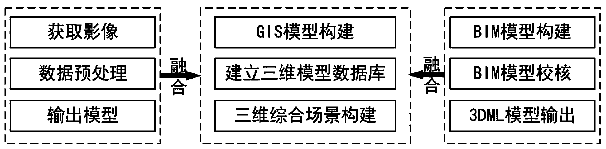
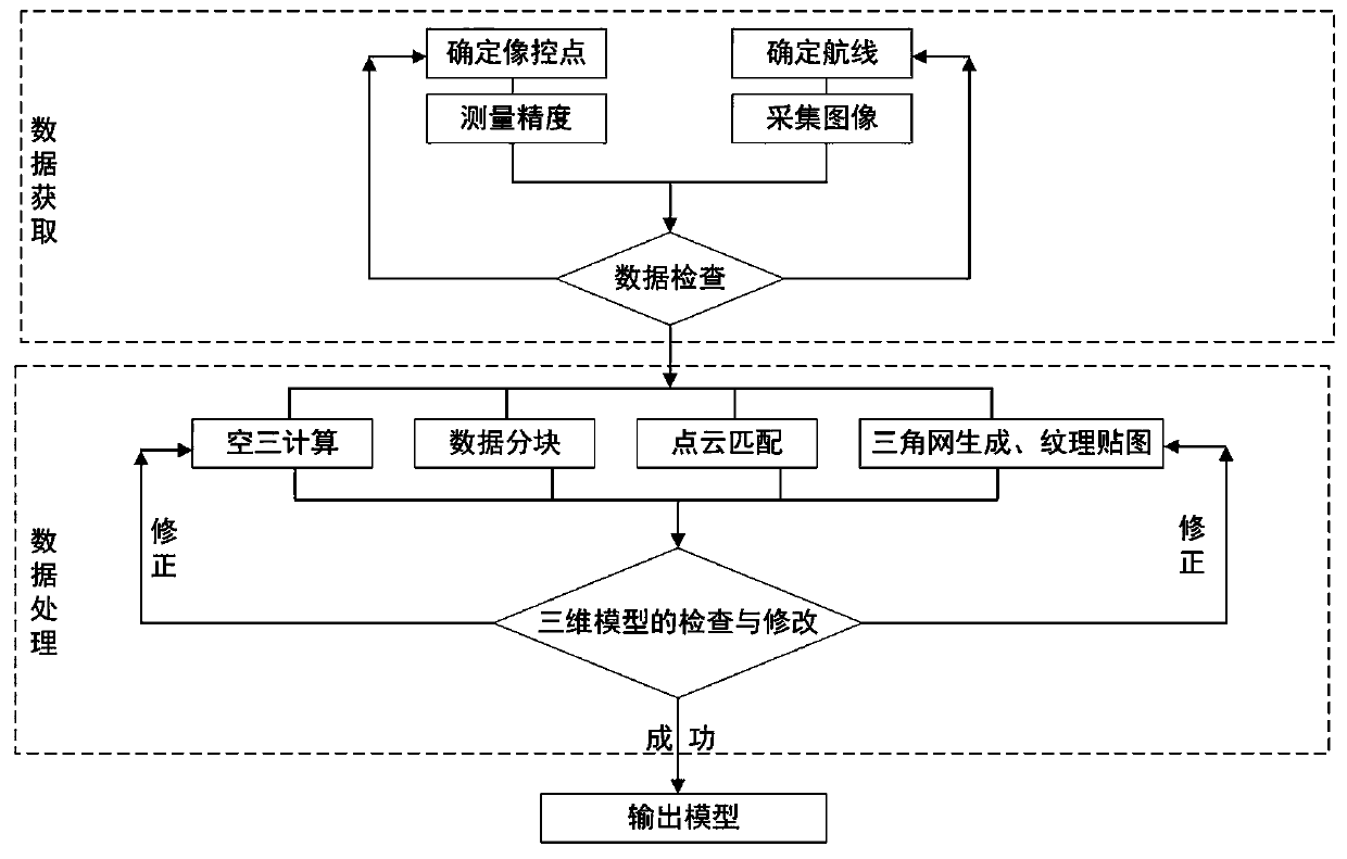
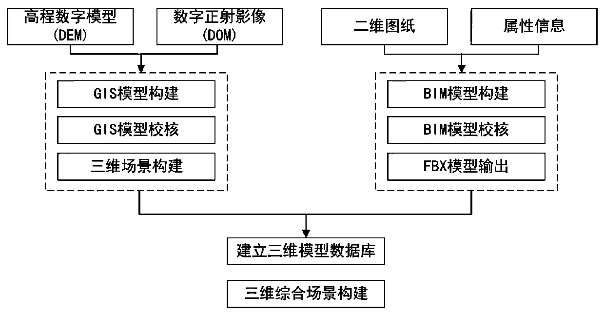
[0043] Such as Figure 1-Figure 3 As shown, the present invention provides a three-dimensional modeling technology based on oblique photography assisted BIM and GIS.

[0044] Specifically include the following steps:

[0045] (1) Acquisition of images: oblique photographic aerial surveys of the same position and multiple high-resolution images from different angles.

[0046] (1.1) Camera calibration: use Zhang Zhengyou’s calibration method for camera calibration, use the camera to be calibrated to take pictures of the calibration board at different positions and attitudes; use the camera to be calibrated to take pictures of the prepared calibration board from different positions and attitudes, at least Acquire 3 images. ...


PUM


Abstract

The invention discloses a three-dimensional modeling technology based on oblique photography assisted BIM and GIS. The method is characterized in that high-resolution images at the same position and at multiple different angles are taken as the basis of oblique photography aerial survey, three-dimensional modeling is carried out through calculation, a BIM technology is used for processing buildingmonomers and internal information, and spatial geographic information data are integrated and analyzed in a GIS through data conversion. The invention relates to the technical field of three-dimensional modeling, in particular to a three-dimensional modeling technology based on oblique photography assisted BIM and GIS. The three-dimensional modeling technology can automatically establish the three-dimensional model, has the characteristics of high efficiency, high precision, high authenticity and low cost, combines the BIM to carry out refined internal processing on the building model, carries out three-dimensional visualization on the model processing through the 3D GIS, has the characteristics of rapidness and reality in modeling, and has the characteristic of space visualization in management and analysis. The problems that traditional three-dimensional modeling is low in efficiency, high in cost and insufficient in model precision, and geographic information management cannot be carried out are solved.

Description


Claims


Application Information

Patent Timeline
Owner TANGSHAN IND VOCATIONAL TECHN COLLEGE
Why Eureka
Try Eureka