Method and system for evaluating land degradation condition by fusing multi-source remote sensing indexes

A land degradation and land technology, applied in the direction of instruments, calculations, character and pattern recognition, etc., can solve the problem of inaccurate land degradation evaluation data, inability to provide feedback and measures for land degradation status, and inability to fully reflect the degree of land degradation and the characteristics of time and space, etc. question

Active Publication Date: 2019-08-27
SHENZHEN UNIV
View PDF5 Cites 7 Cited by
  • Summary
  • Abstract
  • Description
  • Claims
  • Application Information

AI Technical Summary

Problems solved by technology

[0006] The technical problem to be solved by the present invention is that in the prior art, only a single indicator or a few indicators are used to evaluate the land degradation status, which cannot fully reflect the degree of land degradation and the spatio-temporal characteristics, resulting in insufficient evaluation data of the land degradation status in the research area. Accurate, timely feedback and measures cannot be effectively made according to the state of land degradation. The p

Method used


Image

  • Method and system for evaluating land degradation condition by fusing multi-source remote sensing indexes
  • Method and system for evaluating land degradation condition by fusing multi-source remote sensing indexes
  • Method and system for evaluating land degradation condition by fusing multi-source remote sensing indexes

Examples


Embodiment Construction

[0060] In order to make the object, technical solution and advantages of the present invention more clear and definite, the present invention will be further described in detail below with reference to the accompanying drawings and examples. It should be understood that the specific embodiments described here are only used to explain the present invention, not to limit the present invention.

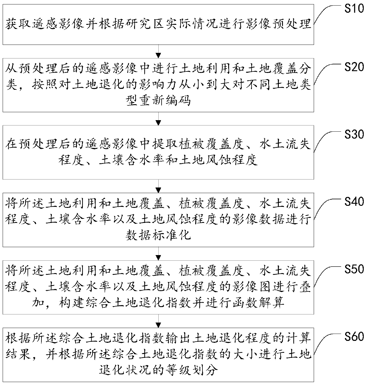
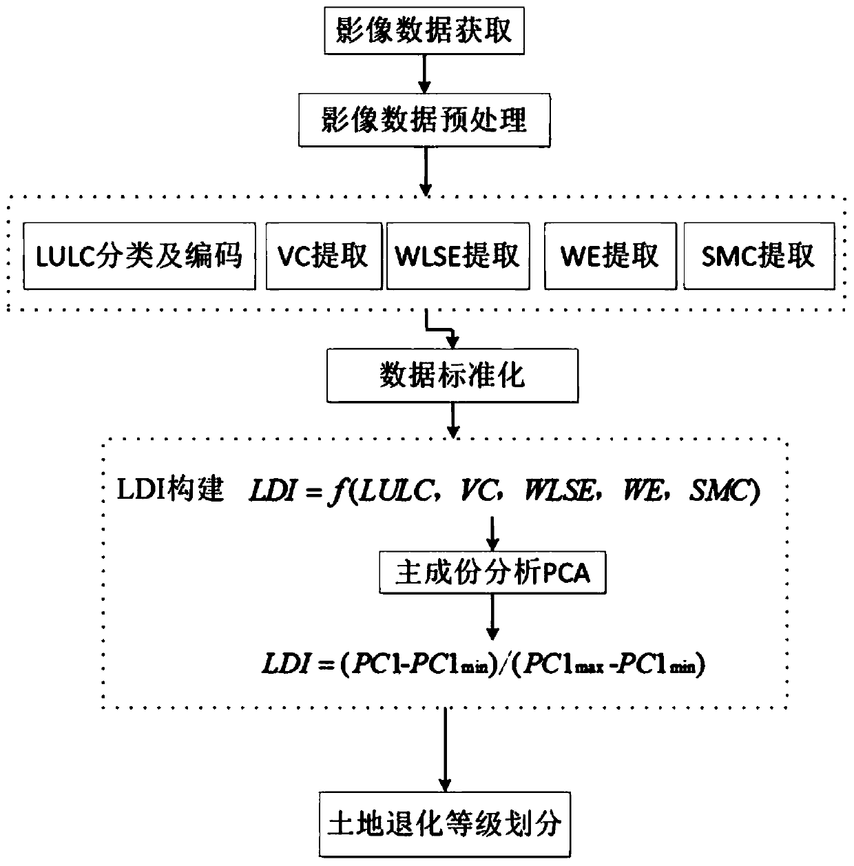
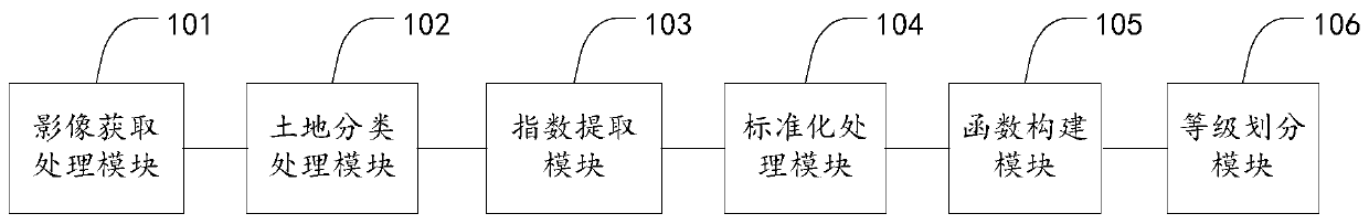
[0061] The method for evaluating the state of land degradation by fusing multi-source remote sensing indicators described in a preferred embodiment of the present invention, such as figure 1 with figure 2 Shown, a kind of fusion multi-source remote sensing index evaluates the method for land degradation state, wherein, the method for described fusion multi-source remote sensing index evaluation land degradation state comprises the following steps:

[0062] Step S10, acquiring remote sensing images and performing image preprocessing according to the actual situation of the research area...


PUM


Abstract

The invention discloses a method and system for evaluating a land degradation condition by fusing multi-source remote sensing indexes. The method comprises the following steps of acquiring a remote sensing image and carrying out image preprocessing according to the actual condition of a research area; carrying out the land utilization and land coverage classification on the preprocessed remote sensing image, and recoding different land types according to the influence on land degradation from small to large; extracting a vegetation coverage degree, a water and soil loss degree, a soil water content and a land wind erosion degree from the preprocessed remote sensing image; after data standardization is carried out on the image data of the five indexes, superposing the images, constructing acomprehensive land degradation index, and carrying out the function calculation; outputting a calculation result of the land degeneration degree according to the comprehensive land degeneration index, and grading the land degeneration condition according to the comprehensive land degeneration index. The comprehensive land degradation index is obtained by integrating the plurality of indexes, so that the land degradation condition is quickly identified from the remote sensing image.

Description

technical field [0001] The invention relates to the technical field of remote sensing and ecological environment protection, in particular to a method and system for comprehensively evaluating land degradation status by integrating multi-source remote sensing indicators. Background technique [0002] Land resources provide important material conditions for human survival and development. However, in recent years, irrational land use and poor management of land resources, coupled with population expansion, have led to serious land degradation around the world. Land degradation refers to the reduction or loss of land biological or economic production capacity caused by human activities, coupled with the impact of natural processes such as climate change, which amplifies the impact of land degradation. [0003] Remote sensing and geographic information systems (GIS) technology have achieved good results in land degradation research, but the commonly used land degradation indic...

Claims


Application Information

Patent Timeline
IPC IPC(8): G06K9/00G06K9/62
CPCG06V20/188G06F18/2135G06F18/24
Inventor 杨超李清泉邬国锋
Owner SHENZHEN UNIV
Why Eureka
Try Eureka