Unmanned aerial vehicle remote sensing image real-time splicing method and system

A technology for remote sensing and unmanned aerial vehicles, applied in the field of real-time splicing of remote sensing images of unmanned aerial vehicles, can solve the problems of complex technical process, inability to provide global situation in real time, and long response period.

Active Publication Date: 2019-10-08
CHENGDU UNION BIG DATA TECH CO LTD
View PDF9 Cites 14 Cited by
  • Summary
  • Abstract
  • Description
  • Claims
  • Application Information

AI Technical Summary

Problems solved by technology
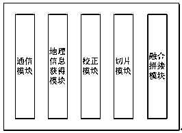
This kind of technical process is complex, separated from internal and external industries, and has a long response cycle, which cannot meet the application scenarios that

Method used


Image

  • Unmanned aerial vehicle remote sensing image real-time splicing method and system
  • Unmanned aerial vehicle remote sensing image real-time splicing method and system
  • Unmanned aerial vehicle remote sensing image real-time splicing method and system

Examples


Embodiment Construction

[0082] In order to understand the above-mentioned purpose, features and advantages of the present invention more clearly, the present invention will be further described in detail below in conjunction with the accompanying drawings and specific embodiments. It should be noted that the embodiments of the present invention and the features in the embodiments may be combined with each other without conflicting with each other.

[0083] In the following description, many specific details are set forth in order to fully understand the present invention. However, the present invention can also be implemented in other ways different from the scope of this description. Therefore, the protection scope of the present invention is not limited by the following disclosure. limitations of specific examples.

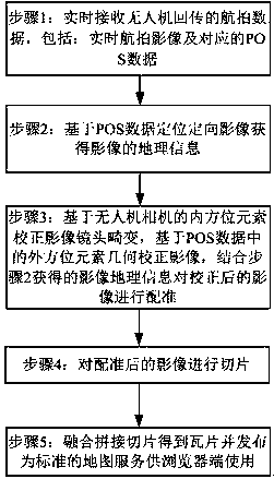
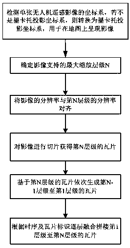
[0084] Please refer to figure 1 , the present invention provides a method for real-time splicing of remote sensing images of drones, the method comprising:

[0085] (1) Receive the a...


PUM


Abstract

The invention discloses an unmanned aerial vehicle remote sensing image real-time splicing method and system, and the method comprises the steps: receiving aerial photography data returned by an unmanned aerial vehicle in real time, including a real-time aerial photography image and corresponding POS data; positioning the directional image based on the POS data to obtain geographic information ofthe image; correcting image lens distortion based on inner orientation elements of the unmanned aerial vehicle camera, correcting images based on outer orientation element geometry in POS data, and performing registration on the corrected images by combining the image position information geography obtained in the step 2; slicing the registered image; fusing the tiles obtained by splicing the slices and publishing the tiles as a standard map service for the browser end to use. Images returned by the unmanned aerial vehicle can be positioned, oriented, corrected and spliced in real time, and aglobal real-scene map of an aerial photography area of the unmanned aerial vehicle is presented in real time.

Description

technical field [0001] The invention relates to the technical field of UAV remote sensing image processing, in particular to a method and system for real-time splicing of UAV remote sensing images. Background technique [0002] At present, drone aerial survey mainly obtains remote sensing images through drone aerial photography in the field, and offline processing of images in the office provides map services. This kind of technical process is complicated, the internal and external industries are separated, and the response cycle is long, which cannot meet the application scenarios that require rapid response. In addition, real-time live broadcast video data of drones can only obtain local area information, and cannot provide real-time global situation. [0003] In scenarios such as emergency rescue that require high real-time response speed, aerial survey operations are required to process remote sensing images in real time and provide global situation map services. Cont...

Claims


Application Information

Patent Timeline
IPC IPC(8): G06T5/00G06T3/40G06T7/33G01C21/20G01C21/16
CPCG01C21/165G01C21/20G06T3/4038G06T5/006G06T7/33G06T2207/10032G06T2207/20221G06T2207/30181
Inventor 不公告发明人
Owner CHENGDU UNION BIG DATA TECH CO LTD
Why Eureka
Try Eureka