Intersection expression and vehicle infrastructure target matching method for cooperative vehicle infrastructure system (CVIS) environment

An intersection and target matching technology, applied in the field of intersection expression and vehicle-road target matching in a vehicle-road collaborative environment, can solve the problems of algorithm accuracy, instability, large measurement data, etc. Small throughput, easy-to-achieve effects

Active Publication Date: 2019-10-11
WUHAN UNIV OF TECH
View PDF7 Cites 4 Cited by
  • Summary
  • Abstract
  • Description
  • Claims
  • Application Information

AI Technical Summary

Problems solved by technology

[0006] Among them, the measurement data of method 1 is large, the data calculation is more cumbersome, and the error of latitude and longitude can easily lead to the failure of vehicle road target matching; the method 2 has extremely high requirements for the accuracy of the electronic map, and the storage capacity of the secondary map is large, and it is affected by the accuracy of the algorithm. , so the method is extremely unstable
[0007] Although the above two methods have practical application value for vehicle-road target matching at intersections in a vehicle-road collaborative environment, they both have the disadvantages of high precision requirements, instability, and limitations by intersection types.

Method used


Image

  • Intersection expression and vehicle infrastructure target matching method for cooperative vehicle infrastructure system (CVIS) environment
  • Intersection expression and vehicle infrastructure target matching method for cooperative vehicle infrastructure system (CVIS) environment
  • Intersection expression and vehicle infrastructure target matching method for cooperative vehicle infrastructure system (CVIS) environment

Examples


Embodiment 1

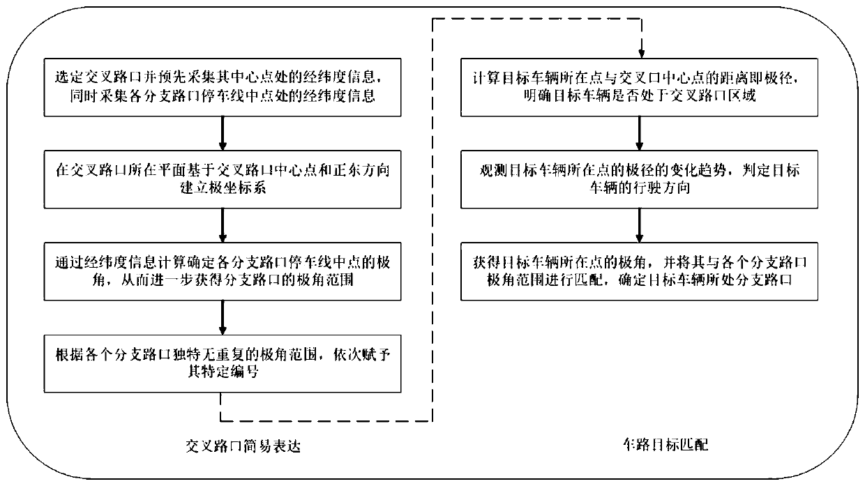
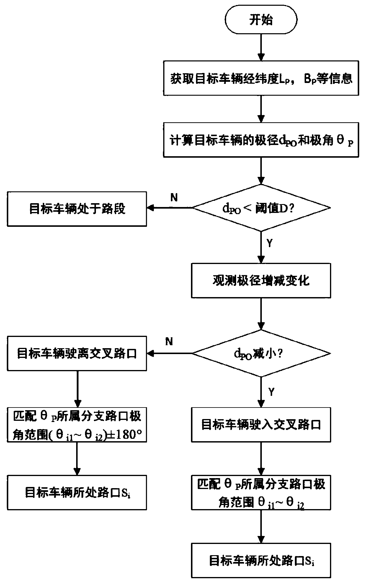
[0087] refer to Figure 4 , to complete the intersection expression and vehicle-road target matching in the vehicle-road collaborative environment, the specific steps are as follows:

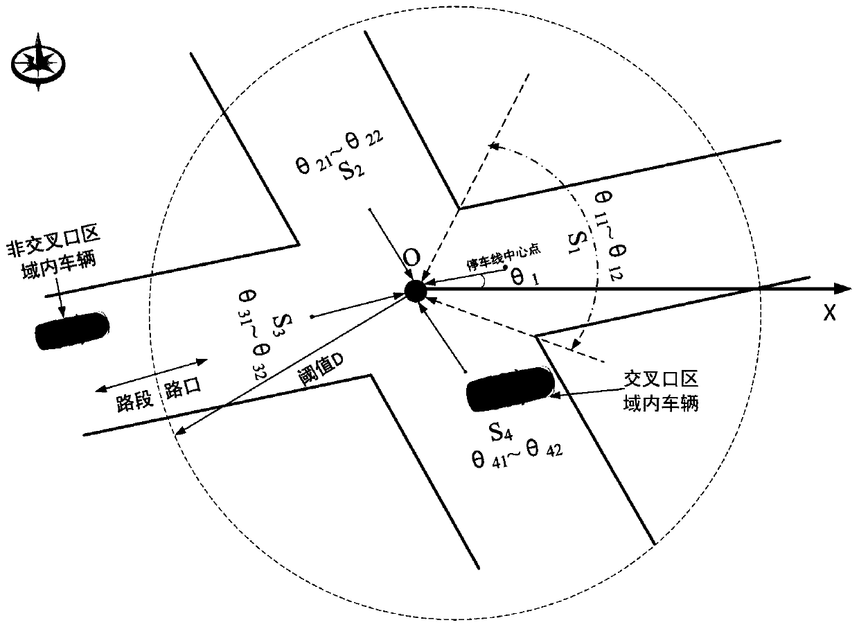
[0088] ① It is clear that the symmetrical intersection has four branch intersections, and the latitude and longitude information L at the center point O is collected O , BO and the latitude and longitude information L at the midpoint of the stop line at the four branch intersections i , B i ;

[0089] ② With the center point O as the pole and the due east direction as the polar axis direction, establish a polar coordinate system on the same plane as the intersection;

[0090] ③Measure the polar angles of the midpoints of the stop lines at the four branch intersections in the above polar coordinate system, and then obtain the polar angle ranges of the branch intersections, which are respectively denoted as θ 11 ~θ 12 , θ 21 ~θ 22 , θ 31 ~θ 32 , θ 41 ~θ 42 , and give each branch interse...

Embodiment 2

[0096] refer to Figure 5 , to complete the vehicle-road target matching at the intersection under the vehicle-road collaborative environment, the specific steps are as follows:

[0097] ① It is clear that the asymmetric intersection has three branch intersections, and the latitude and longitude information L at the center point O is collected O , B O , at the same time collect the latitude and longitude information of the midpoint of the parking line at each branch intersection;

[0098] ② With the center point O as the pole and the due east direction as the polar axis direction, establish a polar coordinate system on the same plane as the intersection;

[0099] ③Measure the polar angles of the midpoints of the stop lines at the three branch intersections in the above polar coordinate system, and then obtain the range of the polar angles of the branch intersections, denoted as θ 11 ~θ 12 , θ 21 ~θ 22 , θ 31 ~θ 32 , and give each branch intersection code S in sequence ...


PUM


Abstract

The invention discloses an intersection expression and vehicle infrastructure target matching method for a cooperative vehicle infrastructure system (CVIS) environment. The method comprises the following methods: 1, a simple intersection expression method, wherein an intersection is selected, and longitude and latitude information of the central point of the intersection and the middle points of stop lines of branch intersections is acquired in advance; a polar coordinate system is established on a plane base where the intersection is located, and polar angles of the middle points of the stoplines of the branch intersections are determined through calculation; and numbers are assigned to the branch intersections according to polar angle ranges of the branch intersections; and 2, a vehicleinfrastructure target matching method, wherein the polar radius of a point where a target vehicle is located is calculated to determine whether the vehicle is located in an intersection area or not;a polar radius change tendency is observed to judge a driving direction of the target vehicle; and matching is carried out on the polar angle of the point where the target vehicle is located and the polar angle ranges of the branch intersections to determine the branch intersection where the target vehicle is located. The method disclosed by the invention has the advantages that any intersection can be very flexibly and easily defined; and whether the target vehicle is located in the intersection area or not can be stably and efficiently judged, and the driving direction of the vehicle and thebranch intersection where the vehicle is located can be stably and efficiently determined.

Description

technical field [0001] The invention relates to the technical field of vehicle positioning under the condition of vehicle-road coordination, in particular to a method for expressing intersections and matching vehicle-road targets under the environment of vehicle-road coordination. Background technique [0002] Road level intersection is an important part of the traffic system, a key node and hub of the road traffic network, and a place where pedestrians and vehicles turn, merge, and diverge. While connecting the road network and bearing a large amount of traffic flow, the conflicts between vehicles and pedestrians, vehicles and vehicles, especially motor vehicles and non-motor vehicles within the range of road intersections have become important factors that induce road traffic accidents. [0003] In order to ensure the safe passage of pedestrians and vehicles at road intersections, technologies such as Cooperative Vehicle Infrastructure System (CVIS) have been studied or ap...

Claims


Application Information

Patent Timeline
IPC IPC(8): G01C21/30
CPCG01C21/30
Inventor 吕能超文家强吴超仲褚端峰高策
Owner WUHAN UNIV OF TECH
Why Eureka
Try Eureka