Method for realizing rapid recovery of GEO satellite after maneuvering through inter-satellite measurement

A fast recovery and inter-satellite ranging technology, applied in the field of satellite navigation, can solve the problems that recovery time affects the continuity and availability of GEO satellite services, and achieve the effect of improving orbit determination accuracy, reducing service interruption time, and excellent accuracy

Active Publication Date: 2019-11-08
中国人民解放军61540部队
View PDF6 Cites 12 Cited by
  • Summary
  • Abstract
  • Description
  • Claims
  • Application Information

AI Technical Summary

Problems solved by technology

Long orbit recovery time directly affects the continuity and availability of GEO satellite services

Method used


Image

  • Method for realizing rapid recovery of GEO satellite after maneuvering through inter-satellite measurement
  • Method for realizing rapid recovery of GEO satellite after maneuvering through inter-satellite measurement
  • Method for realizing rapid recovery of GEO satellite after maneuvering through inter-satellite measurement

Examples


Embodiment Construction

[0020] The present invention will be further described below in conjunction with the accompanying drawings and embodiments, and the present invention includes but not limited to the following embodiments.

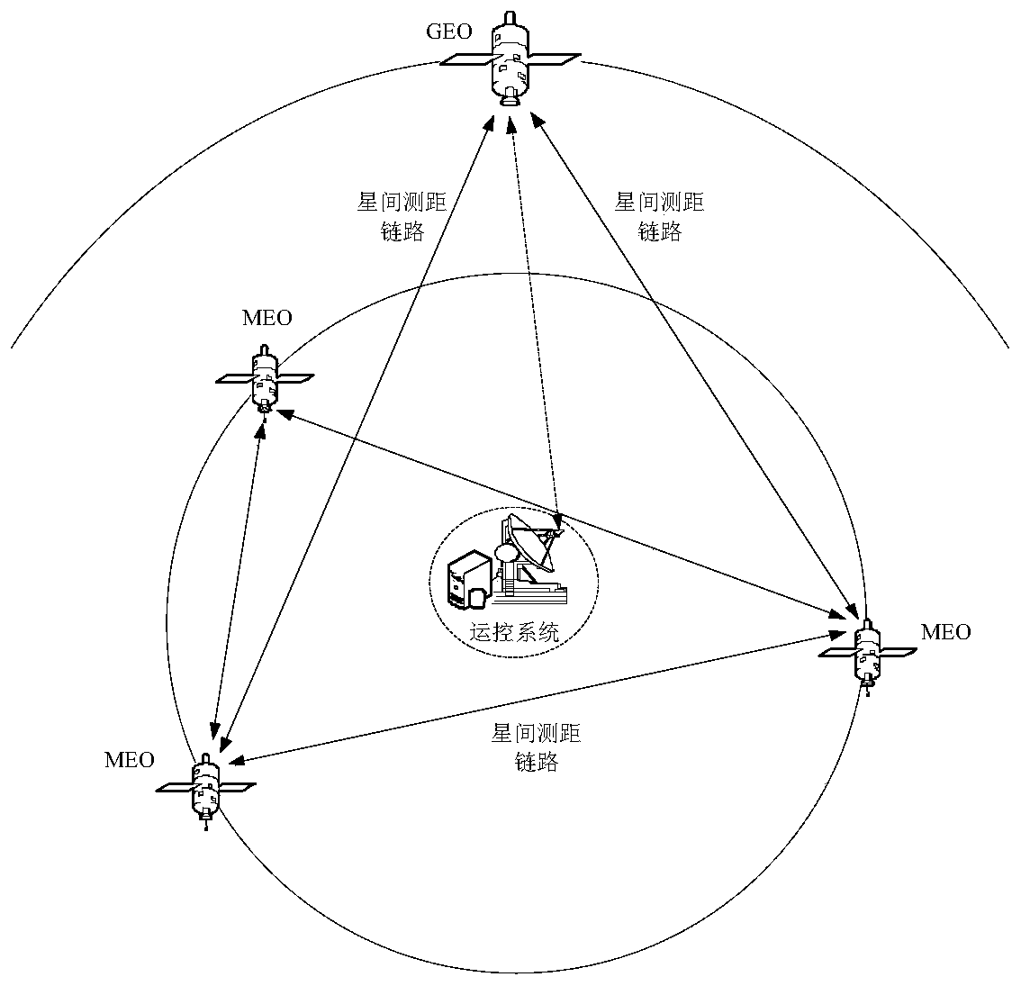
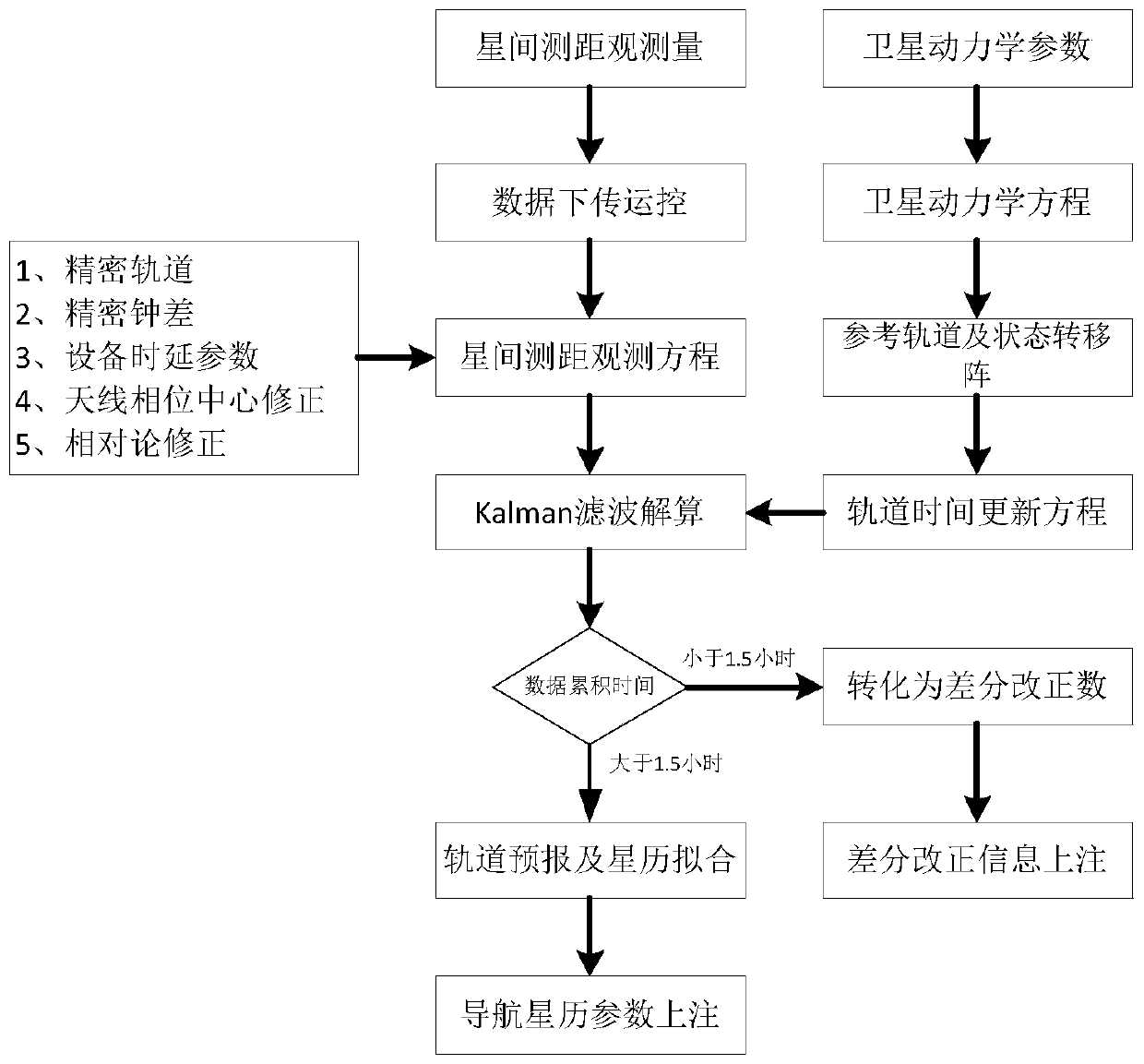
[0021] The present invention uses the Ka-band inter-satellite link load carried by the Beidou three-generation navigation satellite to obtain the two-way precision ranging observation between satellites; preprocess the inter-satellite two-way ranging observation to obtain the instantaneous inter-satellite distance; The position of the Beidou navigation satellite that generates the orbital maneuver is used as a reference, and the precise orbit determination update equation can be constructed by using the instantaneous star distance; based on the analysis results of the main perturbation magnitude of the GEO satellite, the dynamic model of the GEO satellite is constructed, and then the precise determination is formed. The orbit time update equation; the combined use of the mea...


PUM


Abstract

The invention provides a method for realizing rapid recovery of a GEO satellite after maneuvering through inter-satellite measurement. Inter-satellite bidirectional ranging observation data between the GEO satellite and a configurable chain Beidou satellite can be obtained by utilizing an inter-satellite link load; a non-maneuverable Beidou satellite orbit serves as a reference, an orbit determination observation equation is established by utilizing the inter-satellite ranging observation amount between the non-maneuverable Beidou satellite orbit and the GEO satellite, and a satellite state time updating equation can be built by utilizing an orbit dynamics model of the GEO satellite after maneuvering; the observation equation and the satellite state time updating equation are used, the sixnonsingular orbital elements serve as to-be-estimated parameters, a precise orbit of the GEO satellite after maneuvering is obtained, and by using the improved orbit, satellite position information of the GEO satellite after maneuvering is obtained through an upper injection differential correction mode or an orbit forecast and navigation ephemeris parameter fitting mode. The method effectively shortens the time of Beidou GEO satellite navigation positioning service interruption caused by orbital maneuvering, and improves the continuity and availability of services of a satellite navigation system.

Description

technical field [0001] The invention relates to the field of satellite navigation, in particular to a method for rapidly restoring the navigation and positioning service capability after the Beidou GEO satellite orbit is maneuvered by using an inter-satellite bidirectional measurement link. Background technique [0002] The Beidou third-generation satellite navigation system is a global satellite navigation system independently built by my country. Different from satellite navigation systems such as GPS, GLONASS, and GALILEO, the Beidou satellite navigation system adopts a GEO / IGSO / MEO mixed constellation configuration. As a navigation constellation, Beidou GEO satellites also need to broadcast navigation ephemeris. For this reason, regular precise orbit determination and navigation ephemeris parameter update are required. However, due to the limitation of geosynchronous satellite orbit resources, GEO satellites need to perform regular orbital maneuvers in order to maintain...

Claims


Application Information

Patent Timeline
Patent Type & Authority Applications(China)
IPC IPC(8): G01S19/27G01S19/33G01S19/37G01S19/41
CPCG01S19/27G01S19/33G01S19/37G01S19/41Y02D30/70
Inventor 毛悦宋小勇阮仁桂贾小林孙笛王元明
Owner 中国人民解放军61540部队
Why Eureka
Try Eureka