A Construction Method of Urban Geographical Semantic Knowledge Graph

A construction method and semantic knowledge technology, applied in the construction of urban geographic semantic knowledge graph, can solve the problem of not making full use of cutting-edge methods in the field of natural language processing, and achieve the effect of diversifying data sources

Active Publication Date: 2022-03-25
PEKING UNIV
View PDF6 Cites 0 Cited by
  • Summary
  • Abstract
  • Description
  • Claims
  • Application Information

AI Technical Summary

Problems solved by technology

These studies have confirmed that the method of accumulating single data analysis results to obtain regional features is feasible, but the data mining methods used have certain limitations and do not make full use of the cutting-edge methods in the field of natural language processing

Method used


Image

  • A Construction Method of Urban Geographical Semantic Knowledge Graph
  • A Construction Method of Urban Geographical Semantic Knowledge Graph
  • A Construction Method of Urban Geographical Semantic Knowledge Graph

Examples


Embodiment Construction

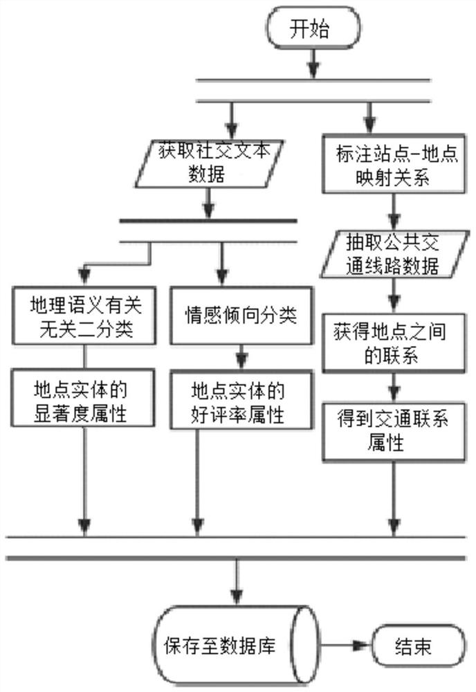
[0040] The present invention will be further elaborated below through specific embodiments in conjunction with the accompanying drawings.

[0041] Such as figure 1 As shown, the construction method of the urban geographic semantic knowledge map of this embodiment includes the following steps:

[0042] 1) Manually divide the area within the Fifth Ring Road in Beijing, and obtain 201 location entities. Using the Weibo corpus with geographic location tags provided by Sina Weibo, there are a total of 4,593,517 entries, and they are divided into corresponding location entities according to their geographic location tags .

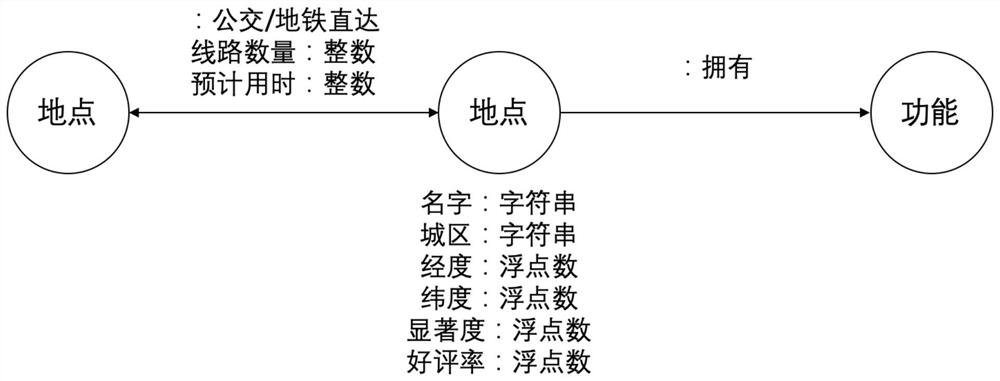
[0043] 2) Use the long-short-term memory (LSTM) model to classify social text data related to or irrelevant to geographical semantics, and then perform multi-classification of geographical semantic topics on microblog texts related to geographical semantics, and calculate the relationship between each location entity and each The salience of a geographic semanti...


PUM


Abstract

The invention discloses a method for constructing an urban geographic semantic knowledge graph. The invention integrates the hidden urban geographic semantics extracted from social text data and the public transportation links between locations, which helps users form a comprehensive understanding of each location in the city, and provides information for travel or urban planning, etc. Decision-making provides reference information; the present invention replaces the conceptual connection with the public transportation connection in reality, making the relationship network depicted by the knowledge map closer to daily life scenes such as location recommendation and location traffic related query; data sources are more diverse, It not only contains the basic information in traditional geographic information systems such as latitude and longitude, urban areas, but also contains hidden geographic semantics extracted from social text data using natural language processing technology, such as the significance of regional functions and favorable ratings.

Description

technical field [0001] The invention relates to the technical field of data mining, in particular to a method for constructing an urban geographic semantic knowledge map. Background technique [0002] Early geographic information acquisition mainly relied on basic surveying and mapping, satellite remote sensing and other means, emphasizing geometric accuracy. With the development of information technology and the rapid popularization of devices such as sensors and smart phones, the object of providing and serving geographical information is gradually shifting from professionals to the general public. In addition, the advancement of data mining technology in recent years has made it possible to extract implicit geographic information from large amounts of data such as social texts and information portals in the network. According to statistics, 18.78% of web text resources contain geographic location information, and 18.6% of web searches are related to geographic location. ...

Claims


Application Information

Patent Timeline
Patent Type & Authority Patents(China)
IPC IPC(8): G06F16/36G06F16/35G06F16/951G06F16/9537G06F40/295G06F40/30G06Q50/00
CPCG06F16/367G06F16/355G06F16/951G06F16/9537G06Q50/01
Inventor 孙艳春黄罡林刘子轩孙志玉
Owner PEKING UNIV
Why Eureka
Try Eureka