
Method and system for fast vectorization of paper map based on latitude and longitude recognition

A vectorization, longitude and latitude technology, applied in vector format still image data, geographic information database, structured data retrieval, etc., can solve the problems of evaluation deviation, time-consuming and labor-intensive, unable to perform manual registration operation, etc., to achieve strong application Value, the effect of increasing efficiency and precision

Active Publication Date: 2022-03-15
HUBEI UNIV
View PDF7 Cites 0 Cited by
  • Summary
  • Abstract
  • Description
  • Claims
  • Application Information

AI Technical Summary

Problems solved by technology

[0004] 1) Manual vectorization cannot produce absolutely uniform operating standards according to different map production requirements, which will cause evaluation deviations to a certain extent;
[0005] 2) Map products need to be updated frequently, and the vector data needs to be redrawn or modified every time the map is updated, which is time-consuming and labor-intensive, and the operation cost is high;
[0006] 3) The manual method will affect the final image quality due to individual differences and human errors
[0008] 1) When the amount of data is too much, the data production efficiency is low;
[0009] 2) The selected registration points cannot be guaranteed to be evenly distributed on the image, which will inevitably cause excessive registration errors;
[0010] 3) It is difficult to find the corresponding reference map with a standard coordinate format for a small number of paper maps, which may result in the inability to perform manual registration operations

Method used


Image

  • Method and system for fast vectorization of paper map based on latitude and longitude recognition
  • Method and system for fast vectorization of paper map based on latitude and longitude recognition
  • Method and system for fast vectorization of paper map based on latitude and longitude recognition

Examples


Embodiment Construction

[0068] In order to illustrate the technical solution of the present invention more clearly, the following will provide the embodiments of the present invention and the technical effects produced by referring to the accompanying drawings. Apparently, those skilled in the art can also obtain other implementation manners according to these drawings without any creative work.

[0069] In this embodiment, a corresponding computer program is written in C++ development language to automatically execute the present invention, that is, a raster image is automatically vectorized by using the written computer program.

[0070] This example will use Figure 5 and Figure 7 Take the paper maps of Tai'an City and Dongying City in Shandong Province as an example. Figure 5 and Figure 7 The paper map shown is scanned into a raster image, and the obtained raster image is vectorized by the computer program written, and the vectorized area is the ecological protection red line area and class...


PUM


Abstract

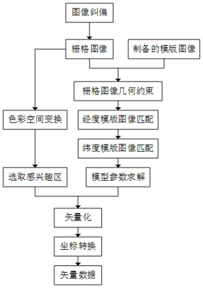
The invention discloses a paper map rapid vectorization method and system based on latitude and longitude recognition, including: S100, correcting the deviation of the grid image; Matching area; S300, read the longitude and latitude template image corresponding to the raster image, and match it with the longitude and latitude to be matched area; S400, use the horizontal / vertical coordinates and longitude / latitude values ​​of the center point pixel obtained by matching to solve the simulation Six parameters of the projective transformation model; S500, perform color space transformation on the raster image after deviation correction; S600, perform vectorization processing on the raster image output in step S500, and convert pixels into geographic coordinates one by one. The invention realizes fast automatic vectorization of the grid image scanned by the paper map by means of modern computer technology, and also realizes precise conversion from pixel coordinates to geographic coordinates.

Description

technical field [0001] The invention belongs to the intersecting technical field of geographic information and computer vision, and in particular relates to a method and system for quickly vectorizing paper maps based on latitude and longitude recognition. Background technique [0002] Vector format is one of the commonly used data formats in GIS application analysis. Vector format data (hereinafter referred to as vector data) can not only be used for spatial analysis, but also express the results of raster data analysis. However, it is sometimes difficult to obtain suitable electronic vector data in relevant application research at present. This is mainly because my country was limited by the development of computer technology in the early days, and geographic data were mostly stored in paper materials, and the data prices provided by commercial companies today Generally more expensive, and the scale is difficult to meet the requirements of practical applications. [0003] ...

Claims


Application Information

Patent Timeline
Patent Type & Authority Patents(China)
IPC IPC(8): G06F16/29G06F16/56G06F16/587
CPCG06F16/29G06F16/56G06F16/587
Inventor 张谦杨洋张良安红红郭佳金郭雨晴
Owner HUBEI UNIV
Learn More