
FengYun-4 satellite lightning imager data assimilation method

An imager and data technology, applied in design optimization/simulation, etc., can solve problems such as empirical humidity profile error and lack of data accumulation

Active Publication Date: 2020-02-07
LANZHOU UNIVERSITY
View PDF5 Cites 9 Cited by
  • Summary
  • Abstract
  • Description
  • Claims
  • Application Information

AI Technical Summary

Problems solved by technology

[0007] [Papadopoulos et al.2005] Obtaining the empirical humidity profile based on the inversion of lightning observation needs to be based on long-term lightning observation data, but as a geostationary orbit satellite launched recently, it lacks sufficient data accumulation, and the empirical humidity profile obtained by inversion There will be a large error in the line

Method used


Image

  • FengYun-4 satellite lightning imager data assimilation method
  • FengYun-4 satellite lightning imager data assimilation method
  • FengYun-4 satellite lightning imager data assimilation method

Examples


Embodiment Construction

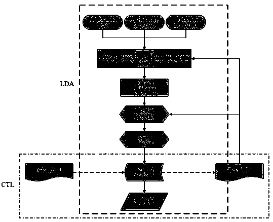
[0062] Such as figure 1 Shown, a kind of Fengyun No. 4 satellite lightning imager data assimilation method of the present invention comprises the following steps:

[0063] S1. The lightning imager data model of Fengyun-4 satellite is gridded, and the lightning data is interpolated to the grid points of the numerical model to obtain the gridded lightning data;

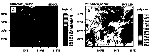
[0064] S2. Fengyun-4 satellite cloud top height data is modeled into a grid, and the cloud top height data is interpolated to the numerical model grid points to obtain the model gridded cloud top height data;

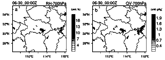
[0065] S3. Create a pseudo-relative humidity field;

[0066] S3-1. The background field of the model is obtained by forecasting the numerical model without assimilating the lightning data;

[0067] S3-2. The lift condensation height obtained in the model background field obtained in the calculation step S3-2, the calculation formula is:

[0068]

[0069] In the formula: LCL is the lifting condensation heigh...


PUM


Abstract

The invention relates to the technical field of satellite lightning imager data assimilation, in particular to a lightning imager data assimilation method which comprises the following steps: S1, gridding a data mode of a FengYun-4 satellite lightning imager; S2, gridding a cloud top height data mode of the FengYun-4 satellite; S3, creating a pseudo relative humidity field; S4, obtaining an analysis field; s5, forecasting a numerical mode; s6, forecasting and checking. According to the method, new cloud top height observation data is introduced in the data assimilation process of the FengYun-4satellite lightning imager, a pseudo relative humidity field close to observation is obtained by adjusting the relative humidity in a background field, and the pseudo relative humidity field is assimilated into a numerical mode by utilizing a 3DVAR assimilation system which is economical in calculation and convenient for business. The test result shows that the assimilation test obviously improves the forecasting of the numerical mode on the heavy rainfall, the ETS and FSS scores of the accumulated rainfall in one hour are improved, and the forecasting maintenance time can reach 6 hours.

Description

technical field [0001] The technical field of data assimilation of satellite lightning imager of the present invention is specifically a data assimilation method of Fengyun No. 4 satellite lightning imager. Background technique [0002] Disastrous weather such as thunderstorms, strong winds, hail, tornadoes and heavy rains caused by mesoscale convective systems will cause serious harm and loss to life safety and social property. Providing timely and accurate forecasts for these disastrous weathers is the key to reducing damage losses. However, in the process of numerical prediction, due to the lack of mesoscale and small-scale convective information in the large-scale driving field, and the complex interaction of thermodynamic and microphysical processes in the mesoscale convective system across scales, the prediction of the mesoscale convective system becomes very difficult. . The accuracy of numerical prediction depends on the accuracy of the initial field. Therefore, a...

Claims


Application Information

Patent Timeline
Patent Type & Authority Applications(China)
IPC IPC(8): G06F30/20
Inventor 刘鹏杨毅
Owner LANZHOU UNIVERSITY
Learn More