Rapid mapping method of lake transparency in large area based on gee

A transparent and large-area technology, applied in satellite remote sensing technology and its application fields, can solve the problems of limited large-area spatial differences and computer processing capabilities

Active Publication Date: 2021-06-25
NANJING INST OF GEOGRAPHY & LIMNOLOGY
View PDF9 Cites 0 Cited by
  • Summary
  • Abstract
  • Description
  • Claims
  • Application Information

AI Technical Summary

Problems solved by technology

However, limited by large regional spatial differences and computer processing capabilities, national, intercontinental or global lake transparency remote sensing synchronous satellite remote sensing monitoring algorithms have not yet been reported.

Method used


Image

  • Rapid mapping method of lake transparency in large area based on gee
  • Rapid mapping method of lake transparency in large area based on gee
  • Rapid mapping method of lake transparency in large area based on gee

Examples


Embodiment Construction

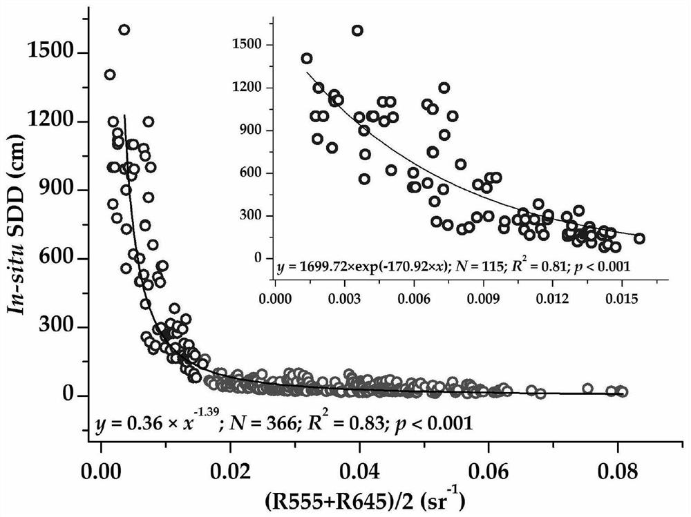
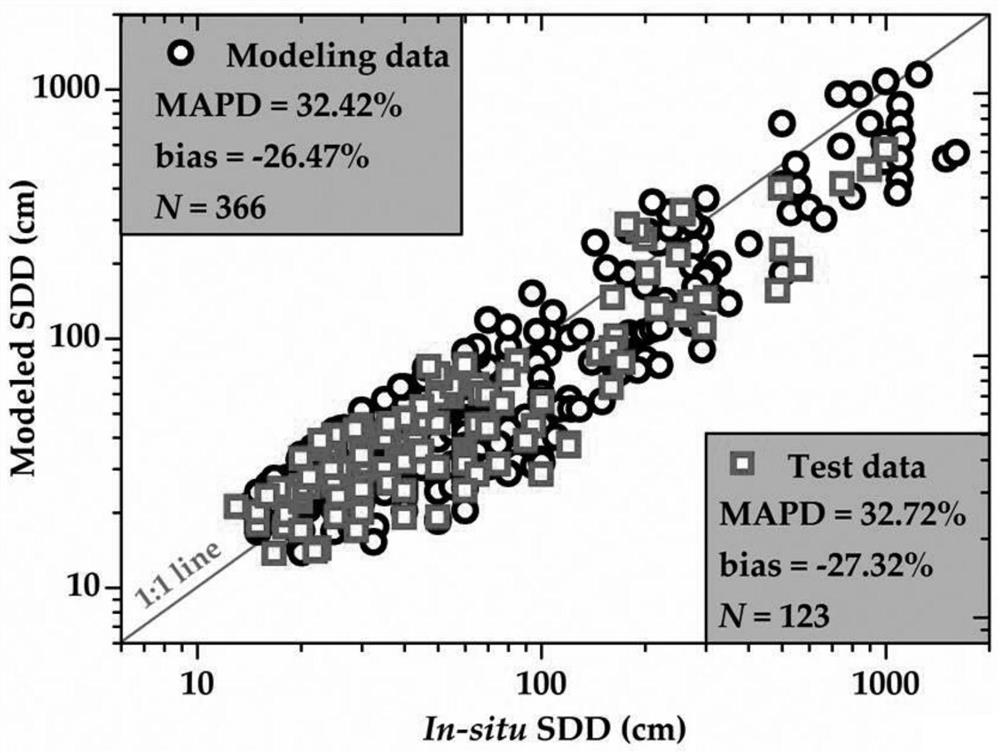
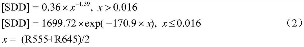
[0029] Take the rapid mapping process of the transparency of large and medium-sized lakes in different regions of China as an example, and further illustrate the specific implementation of the present invention in conjunction with the accompanying drawings and examples:

[0030] (1) On-site data collection representing lakes in different lake regions across the country. China has a vast territory, and the material composition of different lakes varies greatly. There is a phenomenon of "different objects with the same spectrum" in remote sensing of lake water, which makes the previous water color remote sensing research focus on individual or some lakes in a region. In order to construct a remote sensing algorithm applicable to lakes across the country, the study used 2233 sampling point data covering 298 lakes in different lake areas across the country. The number of samples for each lake ranged from 3 to 20, and the sampling time was 2008-2018. In compliance with the water op...


PUM


Abstract

The invention relates to a GEE-based method for quickly mapping the transparency of large-area lakes, which collects the measured transparency data of lakes in different lake areas; obtains the remote sensing data corresponding to the measured transparency data from the GEE computing cloud platform, including remote sensing reflectance and remark information data, and screens out Effective matching data: Based on transparency measured data and effective matching data, a transparency remote sensing model is established and applied to GEE global remote sensing products to achieve rapid transparency mapping at different temporal and spatial scales. The present invention combines remote sensing big data and GEE computer cloud platform, and constructs a large-area transparency inversion model suitable for land remote sensing reflectance by analyzing the simultaneous on-site transparency observation and land remote sensing reflectivity. It can realize rapid mapping of lake transparency in large areas and at different time scales. Provide data support for the evaluation and comprehensive comparison of lake water quality in large regions.

Description

technical field [0001] The invention relates to the field of satellite remote sensing technology and its application, in particular to a GEE-based rapid mapping method for the transparency of large-area lakes. Background technique [0002] Transparency (Secchi DiskDepth, SDD) is an important indicator of lake monitoring, which can comprehensively reflect the water quality of lakes. The reduction of the transparency of the lake is not conducive to the penetration of light into the water column, and is not conducive to the growth of phytoplankton and aquatic vegetation in the lake, which will easily cause the deterioration of the ecological environment of the lake. In addition, under the influence of intense human activities, the eutrophication of lakes is becoming more and more serious, and phytoplankton is increasing explosively; The transparency of the lake is reduced, so the transparency is also an important indicator for evaluating the eutrophication of the lake. After ...

Claims


Application Information

Patent Timeline
Patent Type & Authority Patents(China)
IPC IPC(8): G01N21/49
CPCG01N21/49G01N2021/1793
Inventor 刘东段洪涛
Owner NANJING INST OF GEOGRAPHY & LIMNOLOGY
Why Eureka
Try Eureka