Autonomous surveying and mapping machine

A measuring machine and precision ranging technology, applied in the field of geographic information, can solve problems such as high work cost, low efficiency, and lack of conditions for erecting instruments, so as to reduce labor intensity and operation difficulty, simplify work process, and reduce manual intervention Effect

Active Publication Date: 2015-01-14
许凯华
View PDF9 Cites 0 Cited by
  • Summary
  • Abstract
  • Description
  • Claims
  • Application Information

AI Technical Summary

Problems solved by technology

Traditional equipment relies on manual operation, and the human errors and the errors introduced into the geodetic coordinates in segments are large and there is no effective error correction method
The efficiency of traditional equipment is very low, and obtaining a low-precision three-dimensional geodetic coordinate of the object space often requires a team of professional and technical personnel to work for a long time
It consumes a lot of manpower and time, and the actual work cost is high
[0012] 2) GPS locator: The instrument must be erected on the measured target for observation. This first requires that the measured target has the conditions for erecting the instrument. The target points of the measurement often do not have the conditions to set up the instrument
[0013] 3) Total station: It can only measure angles and distances in a custom coordinate system; it completely relies on manual operation, the human error is large and there is no effective error correction method; when measuring the three-dimensional coordinates of the object, it is necessary to have more than two Known control points; to determine the direction of true north, you must purchase the data of the local GPS control network (if such a network exists locally), or use a gyroscope; to introduce geodetic coordinates, you must use a GPS locator
[0024] 3) Movement and operation: The equipment that makes up the system is large in size and weight, and the system structure is loose. It must be fixed on a large carrier such as a car and operated by multiple people.
[0025] 4) The working method of field data collection and post-processing in the field leads to the unavoidable repetitive field labor
[0027] 6) Expensive: All the components of the mobile road measurement system are outsourced. The high price of these high-end equipment makes the cost of the "mobile road measurement system" high. The mobile road measurement system without laser ranging scanner (no measurement The price of the product is 4 million yuan / set; the price of foreign products with laser scanning distance measuring equipment is higher than 6 million yuan / set

Method used


Image

  • Autonomous surveying and mapping machine
  • Autonomous surveying and mapping machine
  • Autonomous surveying and mapping machine

Examples


Embodiment Construction

[0145] The invention is a portable field work station. For narration is accurate, " road " is defined as in the present invention: be suitable for the earth's land surface that automobile travels. Define "wilderness" as: the Earth's terrestrial surface including roads.

[0146] The technical solution of the present invention will be described in detail below in conjunction with the drawings and embodiments.

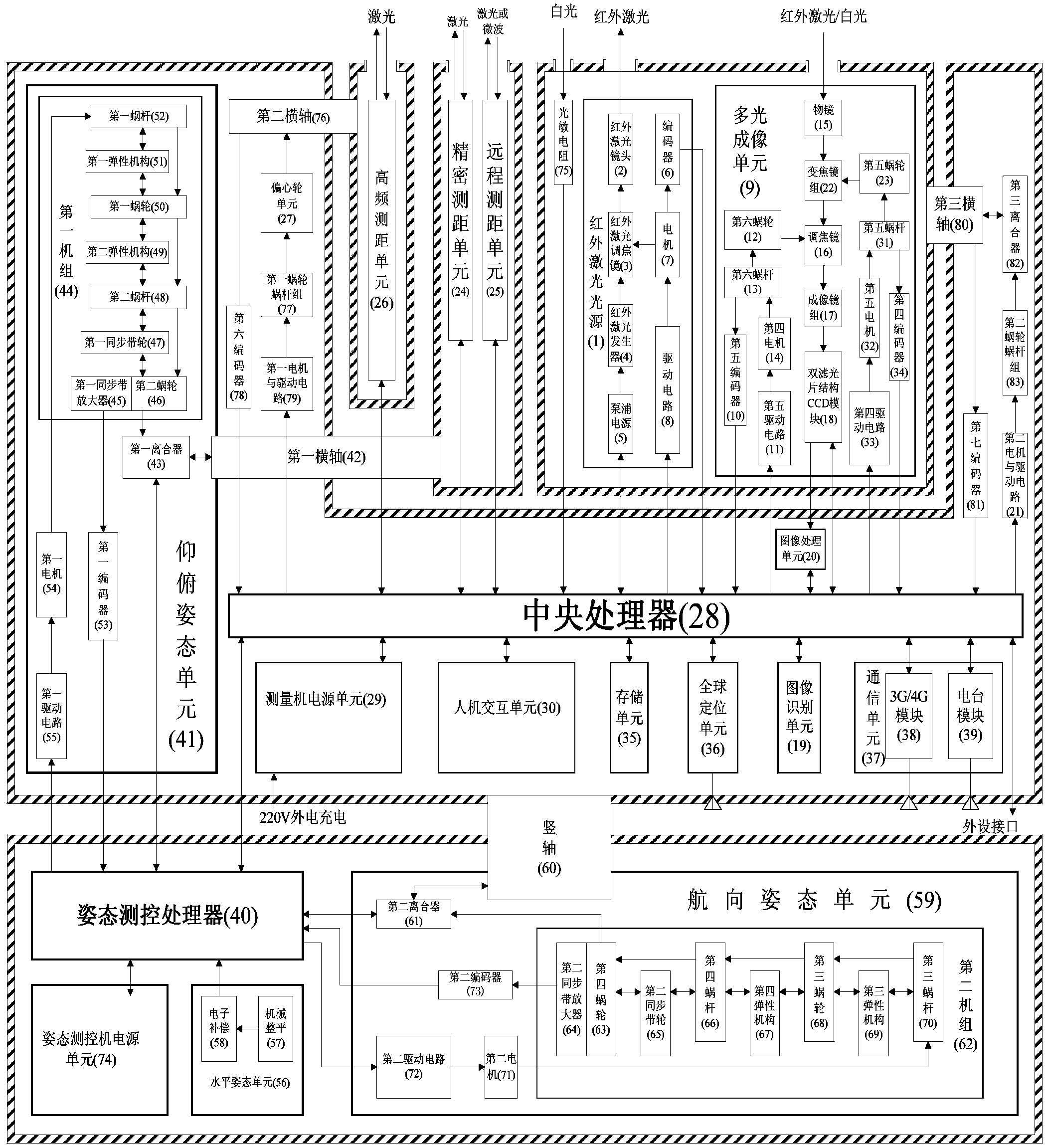
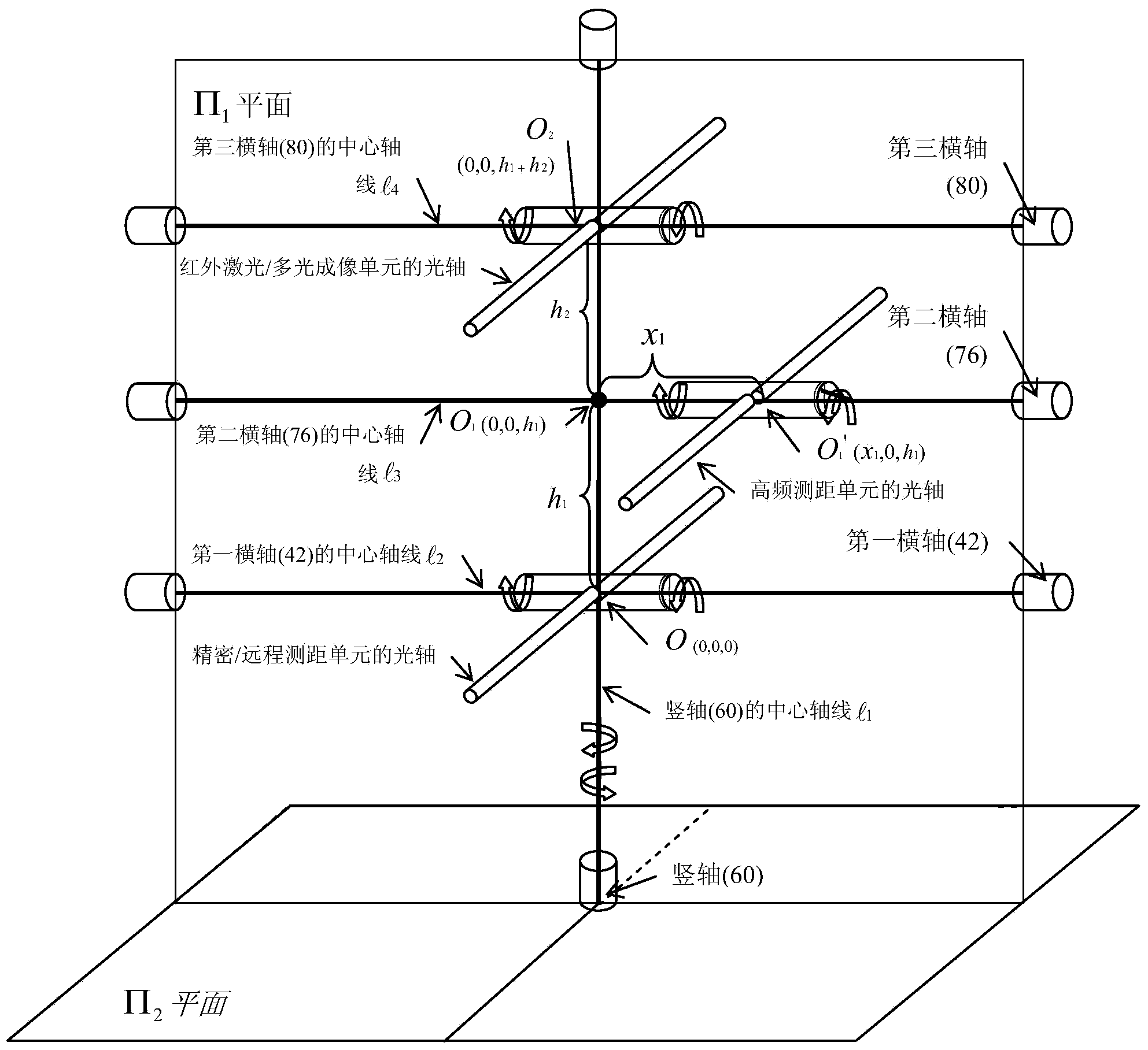
[0147] see figure 1 , 4 , the autonomous surveying and mapping machine provided by the embodiment includes a measuring machine and an attitude measuring and controlling machine.

[0148] The measuring machine includes a central processing unit 28 and an infrared laser light source 1 connected to the central processing unit 28, a multi-light imaging unit 9, a precision ranging unit 24, a remote ranging unit 25, a high-frequency ranging unit 26, and an eccentric wheel unit 27 , image recognition unit 19, image processing unit 20, measuring machine power supply unit 29, ...


PUM


Abstract

The invention relates to an autonomous surveying and mapping machine which comprises a measuring machine and an attitude measurement and control machine, wherein the measuring machine comprises a central processing unit (CPU) (28), an infrared laser source (1), a multi-light imaging unit (9), a precise distance measurement unit (24), a remote distance measurement unit (25), a high frequency distance measurement unit (26), an eccentric gear unit (27), an image identification unit (19), an image processing unit (20), a measuring machine power unit (29), a man-machine interaction unit (30), a memory unit (35), a global positioning unit (36), a communication unit (37) and a photoconductive resistor (75); the attitude measurement and control machine comprises an attitude measurement and control processor (40), a pitch attitude unit (41), a horizontal attitude unit (56), a heading attitude unit (59) and an attitude measurement and control machine power unit (74). The autonomous surveying and mapping machine has the characteristics of being high in accuracy, efficiency, reliability and cost performance, low in cost, portable and intelligent, and being capable of obtaining functionality by emergent property.

Description

technical field [0001] The invention belongs to the technical field of geographic information, and in particular relates to an autonomous surveying and mapping machine. Background technique [0002] Market demand: There are thousands of applications in the geographic information industry stemming from 4 core needs [0003] 1) Obtain the three-dimensional geodetic coordinates of the target; [0004] 2) Obtain the topographic and feature map under the three-dimensional geodetic coordinates; [0005] 3) Obtain the 3D image of the object space under the 3D geodetic coordinates; [0006] 4) Obtain the 3D navigation map based on the 3D image in the geodetic coordinate system. [0007] Technical status: Multiple groups of personnel use a wide variety of multiple groups of instruments and equipment to obtain one of the above core requirements in different ways and form various applications. The existing limitations are low efficiency, time-consuming service, high cost, and limit...

Claims


Application Information

Patent Timeline
Patent Type & Authority Patents(China)
IPC IPC(8): G01C15/00G01B11/16G01B11/00
CPCG01C7/02G01C11/00G01C15/00G05D3/206
Inventor 许凯华
Owner 许凯华
Why Eureka
Try Eureka