Urban ecological vulnerability space prediction method based on GIS and CA simulation

A vulnerability and ecological technology, applied in forecasting, structured data retrieval, instruments, etc., can solve the problem of lack of quantitative analysis of the spatial distribution of urban ecological vulnerability, and achieve the effect of simple operation

Pending Publication Date: 2020-04-28
TIANJIN UNIV
View PDF0 Cites 2 Cited by
  • Summary
  • Abstract
  • Description
  • Claims
  • Application Information

AI Technical Summary

Problems solved by technology

The operation of vulnerability spatial data analysis in urban planning is concentrated on the operation of vector data, and there is a lack of quantitative analysis of the spatial distribution of urban ecological vulnerability

Method used


Image

  • Urban ecological vulnerability space prediction method based on GIS and CA simulation
  • Urban ecological vulnerability space prediction method based on GIS and CA simulation
  • Urban ecological vulnerability space prediction method based on GIS and CA simulation

Examples


Embodiment Construction

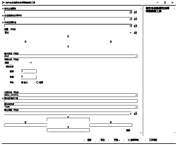
[0038] The specific implementation manner of the present invention will be described in detail below in conjunction with the accompanying drawings and preferred embodiments. Such as Figure 1-Figure 7 As shown, a spatial prediction method of urban ecological vulnerability based on GIS and CA simulation, the secondary development of the Model builder tool based on the GIS platform, the specific implementation method is as follows:

[0039] Step 1: Build the initial model

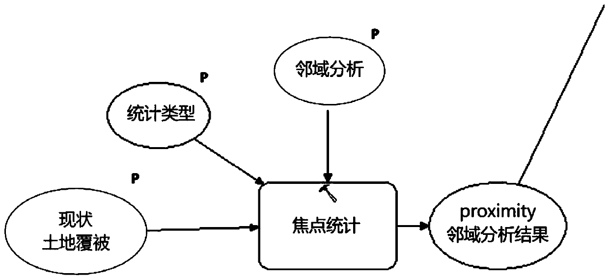
[0040] 1. Input the urban land cover raster data.

[0041] 2. Connect the raster data to the focal statistics tool.

[0042] 2.1 Set the neighborhood type.

[0043] 2.2 Set the neighborhood CA cell value.

[0044] 2.3 Statistical type is average.

[0045] 2.4 Output neighborhood analysis result data (such as figure 1 ).

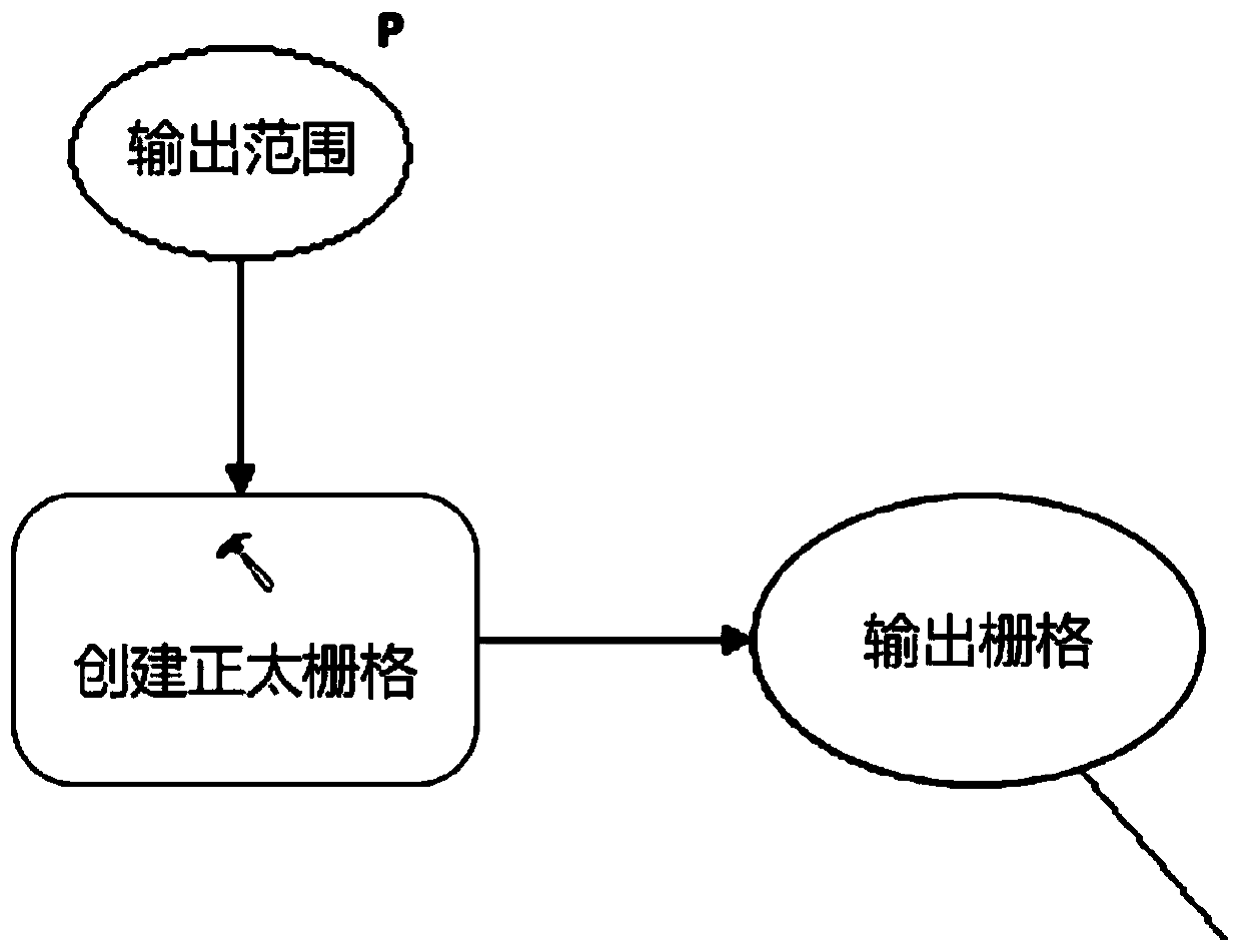
[0046] 3. Load the normal grid tool.

[0047] 3.1 The output scope is determined as the research scope.

[0048] 3.2 To output a raster with normal (Gaussian) distributed random val...


PUM


Abstract

The invention relates to the technical field of urban planning, in particular to an urban ecological vulnerability spatial prediction method based on GIS and CA simulation, which comprises the following steps: creating neighborhood analysis of current land cover data; creating an orthogonally distributed grid; loading ecological vulnerability space evaluation data; identifying a neighborhood ecological vulnerability space of the land for future development; dividing ecological vulnerability space levels of neighborhoods of land for future development; extracting the highest threshold data of the ecological vulnerability space of the neighborhood of the land for the future development; and building an urban ecological vulnerability spatial distribution prediction initial model based on themodel builder, deleting initial data, and completing the prediction model tool for predicting urban ecological vulnerability spatial distribution. According to the method, the defect of empirical judgment in traditional planning is avoided, the urban ecological vulnerability spatial distribution is quantitatively predicted, and the neighborhood becomes logic of the vulnerability spatial probability in the process of predicting the urban ecological vulnerability spatial distribution.

Description

technical field [0001] The invention relates to the technical field of urban planning, in particular to a spatial prediction method of urban ecological vulnerability based on GIS and CA simulation. Background technique [0002] Ecological vulnerability is the focus of urban sustainable development. Predicting the spatial distribution of urban ecological vulnerability is an important support for formulating urban development strategies. Existing spatial predictions of urban ecological vulnerability are mostly based on historical ecological disaster data to empirically determine the spatial distribution of vulnerability. The operation of vulnerability spatial data analysis in urban planning is concentrated on the operation of vector data, and there is a lack of quantitative analysis of the spatial distribution of urban ecological vulnerability. Contents of the invention [0003] The main purpose of the present invention is to provide a spatial prediction method of urban ec...

Claims


Application Information

Patent Timeline
Patent Type & Authority Applications(China)
IPC IPC(8): G06Q10/04G06Q50/26G06F16/29
CPCG06F16/29G06Q10/04G06Q50/26
Inventor 朱丽马俊榕
Owner TIANJIN UNIV
Why Eureka
Try Eureka