Pavement obstacle detection method based on reverse feature matching

A technology of obstacle detection and feature matching, which is applied in the directions of instruments, character and pattern recognition, scene recognition, etc., can solve the problems of low degree of automation and difficult registration, achieve high degree of automation, wide retrieval range, and no need for image registration Effect

Pending Publication Date: 2020-05-01
SOUTHEAST UNIV
View PDF5 Cites 1 Cited by
  • Summary
  • Abstract
  • Description
  • Claims
  • Application Information

AI Technical Summary

Problems solved by technology

[0004] Therefore, the existing road damage remote sensing detection technology has shortcomings such as low de

Method used


Image

  • Pavement obstacle detection method based on reverse feature matching
  • Pavement obstacle detection method based on reverse feature matching
  • Pavement obstacle detection method based on reverse feature matching

Examples


Embodiment 1

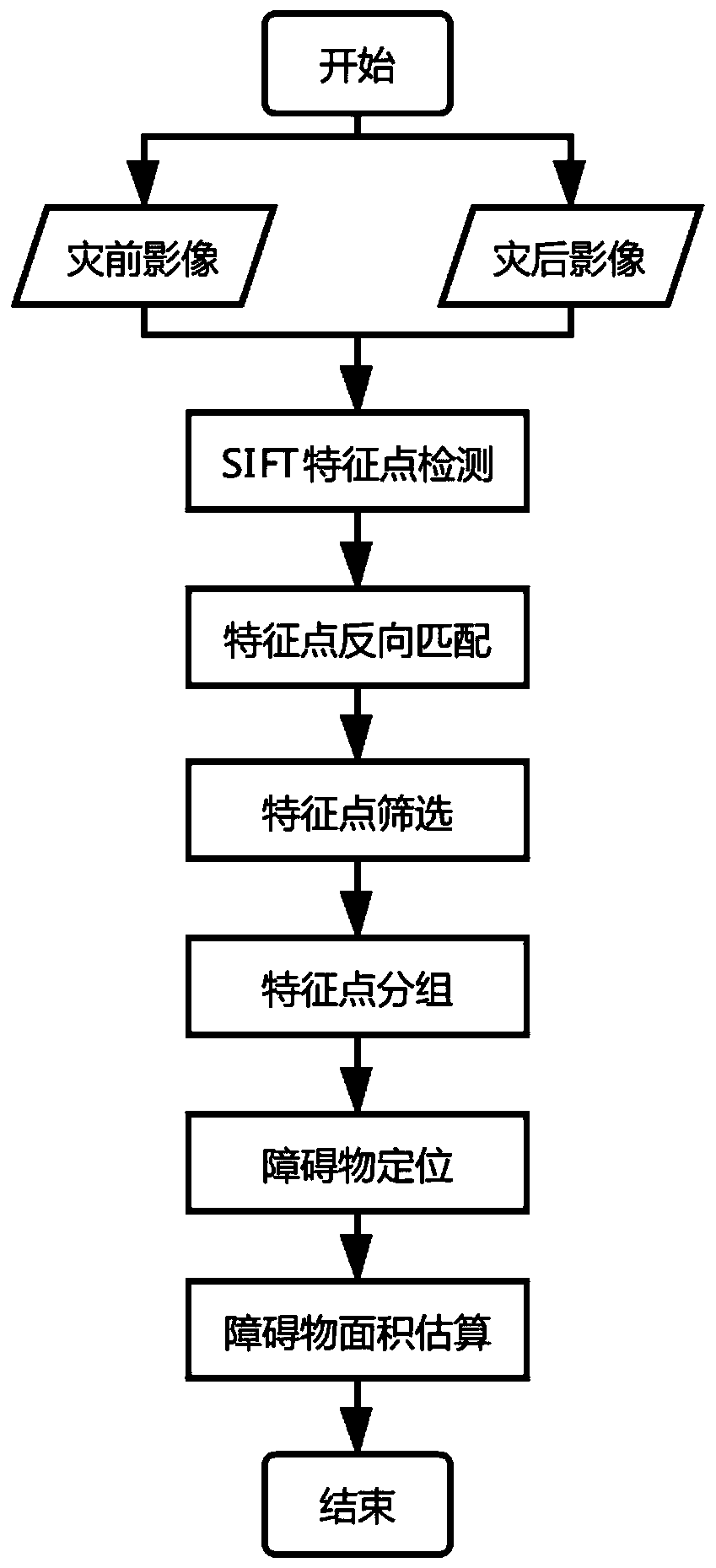
[0052] Example 1: see figure 1 , a road obstacle detection method based on reverse feature matching, the method comprises the following steps:

[0053] Step 1: Calculate the SIFT feature point set for the remote sensing image before and after the road loss and perform feature matching, and invert the matching result to obtain the change information feature point set;

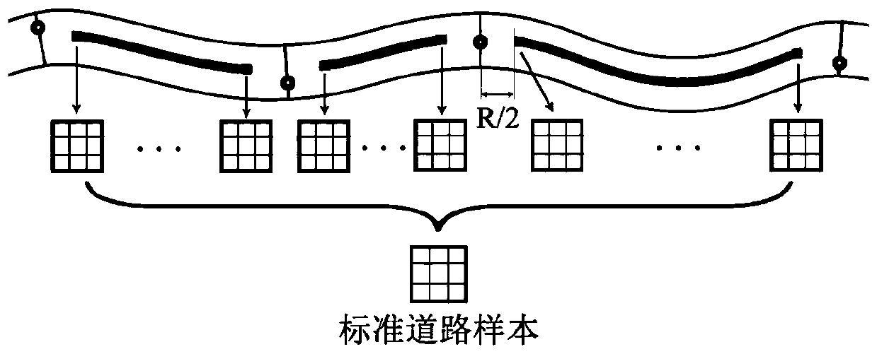
[0054] Step 2, use the road buffer to filter and obtain the change information feature point set in the road area;

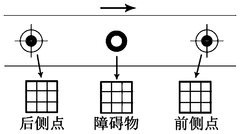
[0055] Step 3, according to the distribution and aggregation degree of feature points, filter out false change feature points and small change feature points;

[0056] Step 4: Preliminarily group the feature points according to the point spacing, and distinguish the feature points belonging to different obstacles;

[0057] Step 5, detect the preliminary grouping result obtained in the previous step, and obtain the final grouping result through similarity judgment;

[0058] Step 6: Obtain the l...


PUM


Abstract

The invention discloses a pavement obstacle detection method based on reverse feature matching. Remote sensing change detection field, the method is based on space-air high-resolution remote sensing images. Change information in an image is extracted by using an SIFT feature point reverse matching method, the area and position information of a pavement obstacle in the image is obtained by processing the change information, the method has the characteristics of large-scale and macroscopic detection, and reference information can be provided for emergency rescue and disaster relief route planning and road rush-repair engineering quantity estimation. The method is characterized in that the method comprises the steps that SIFT feature point sets are calculated for remote sensing images beforeand after road loss respectively, feature matching is carried out, and negation is carried out on a matching result to obtain a change information feature point set; screening by using a road buffer area to obtain a change information feature point set in the road area, and screening out false change points and tiny change points by using a sliding window method; and finally, grouping and combining the feature points to obtain position information of the obstacle, obtaining an approximate range of the obstacle in combination with a region growing method, and performing area estimation. The keytechnology of the invention belongs to the field of remote sensing change detection, but the position and area information of the road obstacle can be obtained without image registration, and the degree of automation is high.

Description

technical field [0001] The invention relates to the detection of road obstacles, in particular to the detection of road obstacles caused by disasters such as mudslides, landslides, and subsidences using remote sensing technology, and belongs to the field of remote sensing technology. Background technique [0002] As of the end of 2018, the total mileage of my country's highways reached 4.8465 million kilometers, and the road density reached 50.48 kilometers per hundred square kilometers. my country's mountainous area accounts for more than two-thirds of the country's total area, and mountainous roads are extremely vulnerable to disasters such as mudslides, landslides, subsidence, and rolling stones. In 2018 alone, there were 501 geological disasters that caused road damage, causing huge economic losses. It is of great practical significance for both military and civilian transportation organizations to promptly ascertain information about obstacles in the direction of road ...

Claims


Application Information

Patent Timeline
IPC IPC(8): G06K9/00G06K9/46G06K9/62
CPCG06V20/58G06V10/462G06F18/22G06F18/23G06F18/211
Inventor 戚浩平康晋洁
Owner SOUTHEAST UNIV
Why Eureka
Try Eureka