GIS technology-based power transmission line tower coordinate visualizing system and method

A technology for transmission lines and processing systems, applied in satellite radio beacon positioning systems, radio wave measurement systems, data processing applications, etc. The effect of simple operation, intelligent operation mode and simple conversion operation

Pending Publication Date: 2020-06-02
GUIYANG BUREAU OF CHINA SOUTHERN POWER GRID CO LTD EHV TRANSMISSION CO
View PDF9 Cites 2 Cited by
  • Summary
  • Abstract
  • Description
  • Claims
  • Application Information

AI Technical Summary

Problems solved by technology

[0004] 1. Low efficiency: manually editing the coordinates in the tower coordinate file is not only time-consuming, but also for KML, KMZ and other files need to be converted into text format files for easy editing, and then need to be converted to KML, KMZ again after editing
[0005] 2. The process is cumbersome: there are many and complicated conversion steps between various file types of tower coordinate files, and the operation is difficult
[0006] 3. Error-prone: manual editing of the tower coordinate file, due to more human factors, it is easier to cause data confusion due to misoperation in the process

Method used


Image

  • GIS technology-based power transmission line tower coordinate visualizing system and method
  • GIS technology-based power transmission line tower coordinate visualizing system and method

Examples


Embodiment Construction

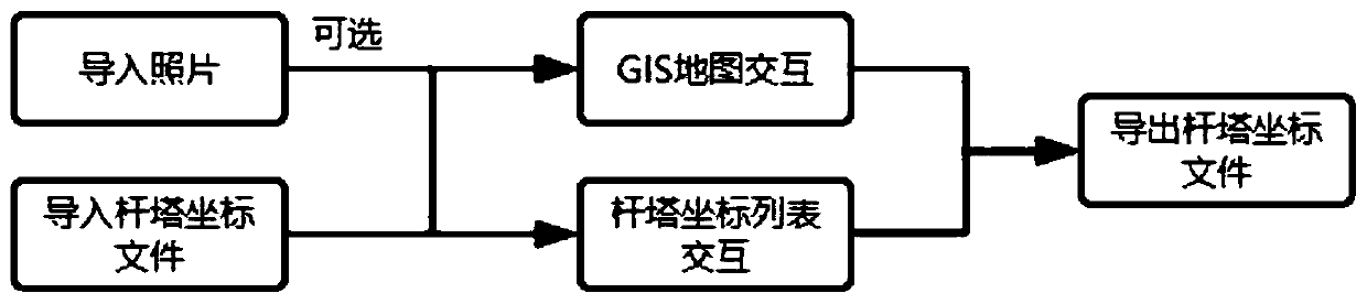
[0031] refer to figure 1 , the transmission line tower coordinate visualization processing system based on GIS technology of the present invention includes a GIS map system and a file processing system. The GIS map system is mainly used for visual presentation of the tower coordinates, which is convenient for manual reference and comparison.

[0032] The GIS map system includes a GIS map layer interaction module and a GIS map data operation module. The GIS map layer interaction module is used for layer landmark interaction and layer landmark information display. The GIS map data operation module is used for layer creation and layer content. renew.

[0033] The file processing system includes a tower coordinate file analysis module, a tower coordinate file generation module and a photo GPS extraction module. The tower coordinate file analysis module is used for tower coordinate file format analysis, and the tower coordinate file generation module is used for tower coordinate fi...


PUM


Abstract

The invention discloses a GIS technology-based power transmission line tower coordinate visualizing system and method. The visualizing system comprises a GIS map system and a file processing system, the GIS map system comprises a GIS map layer interaction module and a GIS map data operation module, the GIS map layer interaction module is used for layer landmark interaction and layer landmark information display, and the GIS map data operation module is used for layer creation and layer content updating; the file processing system comprises a tower pole coordinate file analysis module, a towerpole coordinate file generation module and a photo GPS extraction module. The tower pole coordinate file analysis module is used for analyzing the format of a tower pole coordinate file, the tower pole coordinate file generation module is used for creating the tower pole coordinate file, and the photo GPS extraction module is used for extracting GPS information in a photo and converting the GPS information into a specified data type. According to the visualizing system and method, updating operation of the coordinates of the tower pole can be achieved, and the system and method are simple, rapid and not prone to errors.

Description

technical field [0001] The invention belongs to the technical field of digital processing of towers and poles in power grid systems, and in particular relates to a system and method for visually processing transmission line poles and towers coordinates based on GIS technology. Background technique [0002] In the existing technical scheme, the staff first go to the site to use GPS equipment to collect the new coordinates of the tower, then edit the tower coordinate files in text format such as TXT, CSV, xlsx, etc., and then use software such as GoogleEarthPro to convert the text type tower coordinate files It is a tower coordinate file of KML and KMZ type. [0003] There are following problems in existing method: [0004] 1. Low efficiency: manually editing the coordinates in the tower coordinate file is not only time-consuming, but also needs to be converted to text format files for KML, KMZ and other files to facilitate editing, and then needs to be converted to KML and K...

Claims


Application Information

Patent Timeline
Patent Type & Authority Applications(China)
IPC IPC(8): G06Q50/06G06F9/451G06F16/29G01S19/37
CPCG06Q50/06G06F9/451G06F16/29G01S19/37
Inventor 王郑彭冲徐刚毅俞忠彭超王洪啟李少波杨烯吕露陈跃木杨俊李芳岗李文钊李海锋邓仕航
Owner GUIYANG BUREAU OF CHINA SOUTHERN POWER GRID CO LTD EHV TRANSMISSION CO
Why Eureka
Try Eureka