Map symbol display method and device based on importance of geographic entities in text

A technology of map symbols and geographic entities, which is applied in digital data processing, natural language data processing, editing/combining graphics or text, etc. It can improve the aesthetics of the map, improve the cognitive efficiency, and improve the expression of symbols.

Active Publication Date: 2020-06-05
NANJING NORMAL UNIVERSITY
View PDF2 Cites 0 Cited by
  • Summary
  • Abstract
  • Description
  • Claims
  • Application Information

AI Technical Summary

Problems solved by technology

At present, in the process of natural language text-to-image conversion, the map symbol expression adopts a unified symbol visual variable, that is, by determining the four visual variables of the shape, color, size and direction of the geographic named entity. , relatively important geographical entities cannot be highlighted, and secondary geographical entities cannot be omitted, which will affect the cognitive efficiency of map readers

Method used


Image

  • Map symbol display method and device based on importance of geographic entities in text
  • Map symbol display method and device based on importance of geographic entities in text

Examples


Embodiment Construction

[0019] The present invention will be described in detail below in combination with specific embodiments.

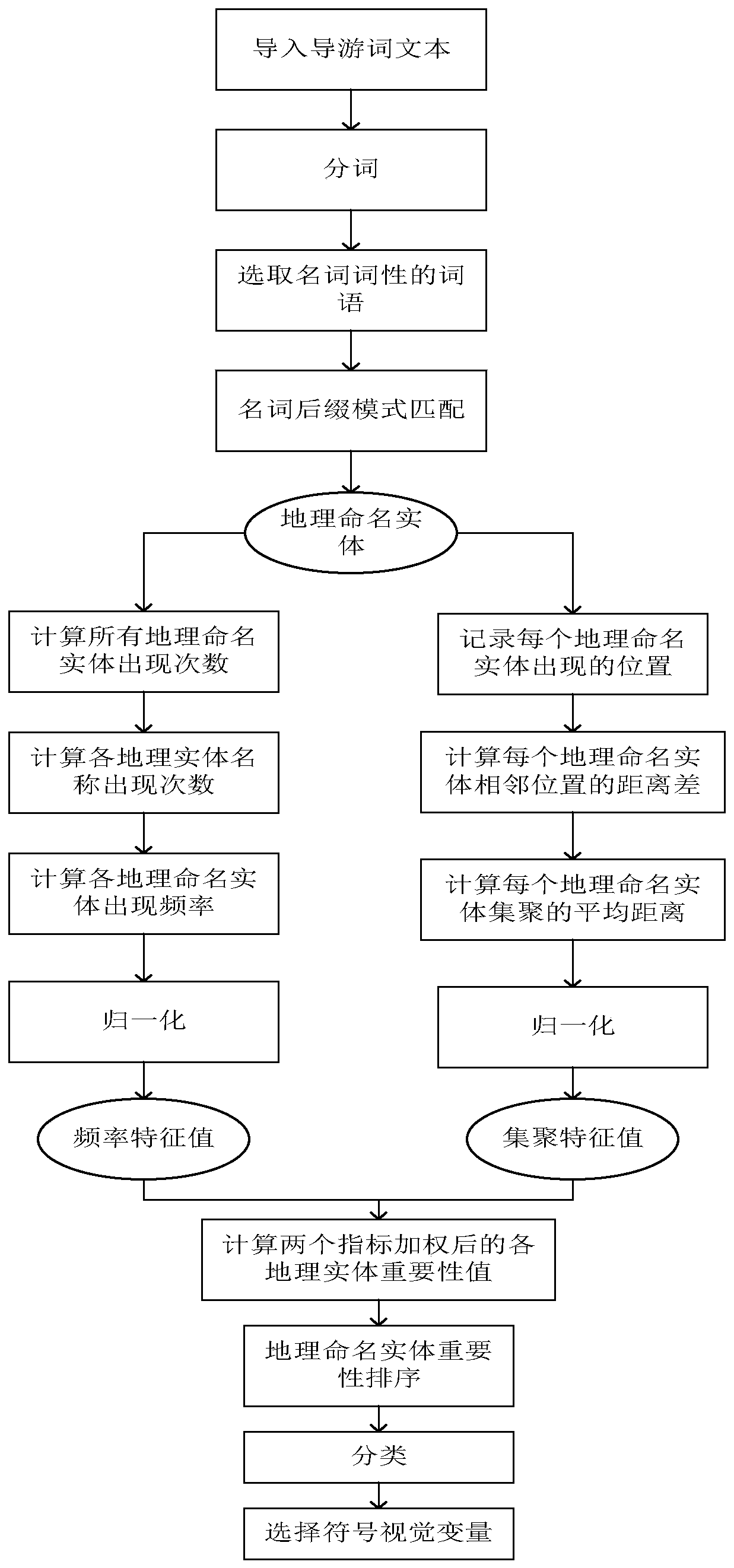
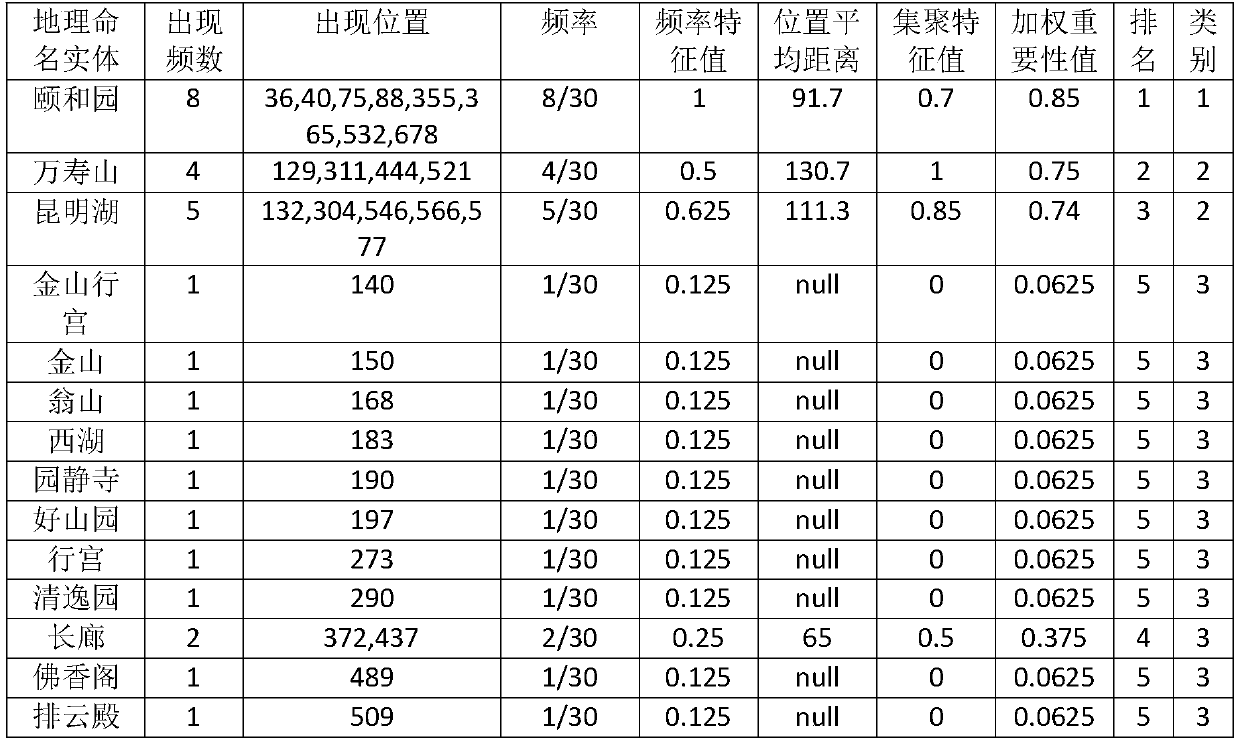
[0020] A method for displaying map symbols based on the importance of geographical entities in the text disclosed in the embodiment of the present invention first obtains the descriptive text related to the map display area, performs word segmentation on the text, selects nouns to form a set, and selects nouns from the selected noun set according to The established geographic named entity naming rule library filters out the geographic named entity collection; then at least counts the frequency feature value and aggregation feature value of each geographic named entity, and then weights and sums each feature value to obtain the importance of each geographic named entity value; then sort the geographic named entities according to the importance value, grade them by natural discontinuity point method, and set the symbol visual variables according to different levels; finally,...


PUM


Abstract

The invention discloses a map symbol display method and device based on the importance of geographic entities in a text, and the method comprises the steps: firstly obtaining a description text related to a map display region, carrying out the word segmentation of the text, selecting nouns, and screening out geographic named entities; at least counting the frequency characteristic value and the aggregation characteristic value of each geographically named entity, and performing weighted summation on the characteristic values to obtain an importance value of each geographically named entity; sorting and grading the geonamed entities according to the importance values, and setting symbol visual variables according to different grades; and finally, displaying the map symbol corresponding to the geographically named entity on the map according to the set symbol visual variable value. According to the method, the importance of the geographical named entities in the text is analyzed by adopting a scientific and effective method, different symbols are selected according to importance levels to design visual variables, the single symbol expression mode of the existing geographical named entities is improved, the map reading efficiency is improved, and the map attractiveness is improved.

Description

technical field [0001] The invention relates to natural language text-to-image conversion technology, in particular to a map symbol display method and device based on the importance of geographic entities in text, and belongs to the technical field of geographic information processing. Background technique [0002] In the process of natural language text-to-image conversion, the symbolization of geographic entities is assisted by information such as shape, color, and size in the text, which helps readers connect map symbols with the real geographic environment and improve cognitive efficiency. At present, in the process of natural language text-to-image conversion, the map symbol expression adopts a unified symbol visual variable, that is, by determining the four visual variables of the shape, color, size and direction of the geographic named entity. , relatively important geographic entities cannot be highlighted, and secondary geographic entities cannot be omitted, which w...

Claims


Application Information

Patent Timeline
Patent Type & Authority Applications(China)
IPC IPC(8): G06F40/295G06T11/60
CPCG06T11/60Y02D10/00
Inventor 洪必文龙毅张翎寇萱
Owner NANJING NORMAL UNIVERSITY
Why Eureka
Try Eureka