UGV driving path planning method based on UAV cooperation sensing

A driving path and collaborative perception technology, applied in two-dimensional position/course control, vehicle position/route/altitude control, instruments and other directions, can solve the uncertainty and uncontrollability of motion trajectory, and it is difficult to effectively complete collision risk prediction and control. Evaluation, automatic collision avoidance, real-time and efficient driving path planning, inability to adapt to dynamic environmental changes, etc., to achieve the effect of automatic planning

Pending Publication Date: 2020-07-14
XI'AN POLYTECHNIC UNIVERSITY
View PDF6 Cites 10 Cited by
  • Summary
  • Abstract
  • Description
  • Claims
  • Application Information

AI Technical Summary

Problems solved by technology

However, due to the complexity of sensing the environment and path planning tasks, UGV automatic driving path planning has problems such as limited vision and inability to adapt to dynamic environmental changes.
Obstacles in the perceived environment are mostly dynamic moving objects, and their trajectory has great uncertainty and uncontrollability. Traditional path planning schemes are difficult to effectively complete collision risk prediction and assessment, automatic collision avoidance and real-time efficient driving. route plan;

Method used


Image

  • UGV driving path planning method based on UAV cooperation sensing
  • UGV driving path planning method based on UAV cooperation sensing
  • UGV driving path planning method based on UAV cooperation sensing

Examples


Embodiment Construction

[0040] The present invention will be described in detail below in conjunction with the accompanying drawings and specific embodiments.

[0041] The invention provides a UGV driving path planning method based on UAV cooperative perception, specifically implemented according to the following steps:

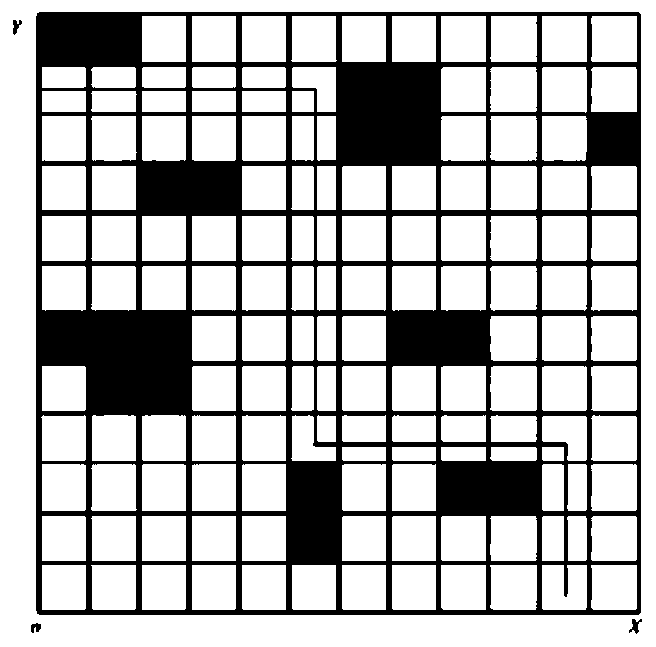
[0042] Step 1, environmental modeling and environmental perception: establish a real-time information interaction environment, obtain scene information, and convert the obtained scene information into a raster scene map;

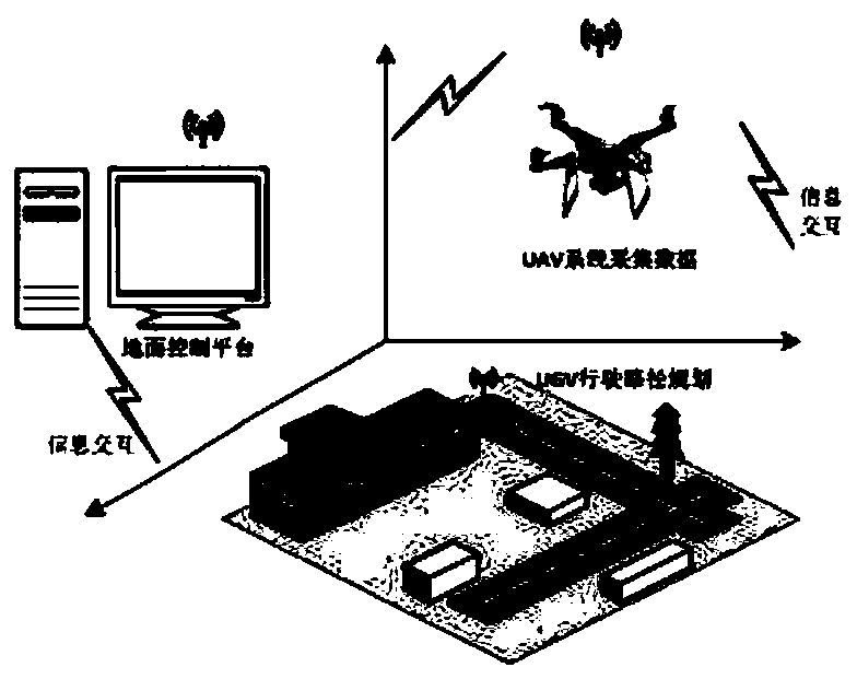
[0043] Environmental modeling and environmental perception: such as figure 1 As shown, the environment model used for UGV path planning is established to realize the information interaction between UAV, UGV and ground working platform. The environment model is as follows: figure 1 As shown, the ground work platform sets the UAV’s flight path, altitude, speed, and UGV’s starting point, end point, driving speed, and visual radius, and then uses the onboard microwav...


PUM


Abstract

The invention discloses a UGV driving path planning method based on UAV cooperation awareness, and the method comprises the following steps: carrying out environmental modeling and environmental awareness: establishing a real-time information interaction environment and obtaining scene information; converting the obtained scene information into a grid scene map, and carrying out obstacle collisionrisk prediction and avoidance; and carrying out path planning in the obtained grid scene map. Under the UAV cooperation mode, an obstacle target is effectively identified, automatic planning of a UGVdriving path is realized, a theoretical and technical support is provided for path planning problems related to intelligent transportation industries such as emergency response, target tracking and rescue, and research has certain perspectiveness and urgency.

Description

technical field [0001] The invention belongs to the technical field of path planning, and relates to a UGV driving path planning method based on UAV cooperative perception. Background technique [0002] Path planning refers to finding an optimal path from the start point to the end point that satisfies the constraint conditions under one or more constraints such as path length, time consumption, and risk cost. Timely and reasonable path planning can provide travel navigation and safety. Great convenience for driving, optimization of logistics distribution, emergency response, etc.; [0003] Unmanned vehicle (Unmanned Ground Vehicle, UGV) automatic driving path planning has always been a hot issue in the research of intelligent transportation path planning. However, due to the complexity of sensing the environment and path planning tasks, UGV automatic driving path planning has problems such as limited vision and inability to adapt to dynamic environmental changes. Obstacle...

Claims


Application Information

Patent Timeline
Patent Type & Authority Applications(China)
IPC IPC(8): G05D1/02
CPCG05D1/0246G05D1/0223G05D1/0214G05D1/0221G05D1/0276
Inventor 王峰萍徐政超李迎杨琼
Owner XI'AN POLYTECHNIC UNIVERSITY
Why Eureka
Try Eureka