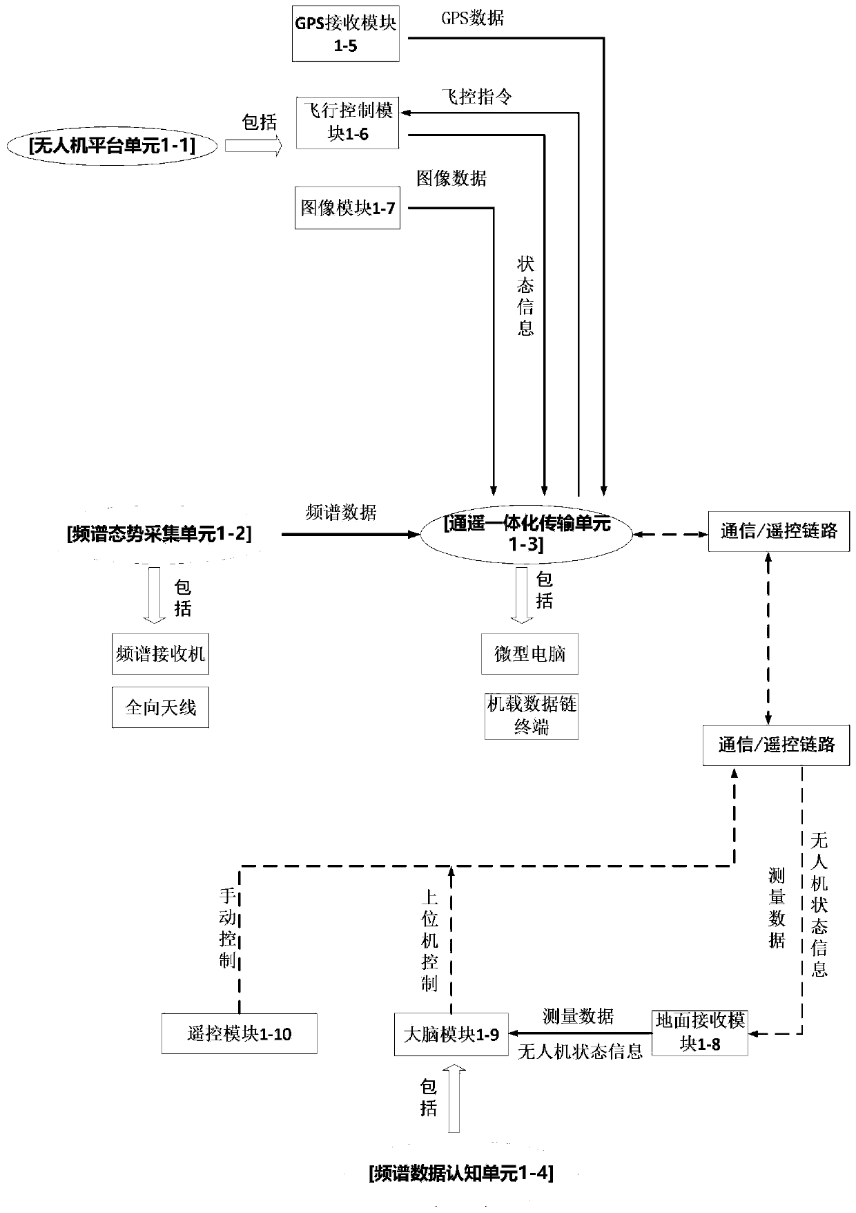
Spectrum situation cognition surveying and mapping device and method based on unmanned aerial vehicle platform
A technology of surveying and mapping device and unmanned aerial vehicle, applied in the field of wireless information transmission
- Summary
- Abstract
- Description
- Claims
- Application Information
AI Technical Summary
Problems solved by technology
Method used
Image

Examples
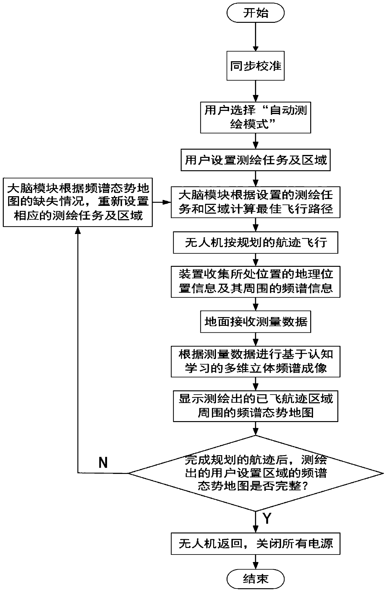
Embodiment 1
[0054] Embodiment 1: Taking the "automatic surveying and mapping mode" task of the spectrum situational awareness surveying and mapping based on the UAV platform as an example, the implementation process (see figure 2 shown) as follows:
[0055] The first step, after completing the pre-start check, select the "automatic surveying and mapping mode", and set the surveying and mapping parameters in the brain module 1-9 as shown in Table 1: the starting position of the measurement area (118.803119, 31.916319), the end position of the measurement area (118.792819, 31.897656), the height is 135m, the surveying and mapping antenna is an ultra-wideband passive omnidirectional antenna (frequency band 20MHz—8GHz), and the surveying and mapping resolution is 10; the brain modules 1-9 independently plan the flight path of the UAV according to the surveying and After the track as Figure 5 shown by the green line.
[0056] The specific implementation process of the brain module 1-9 cont...
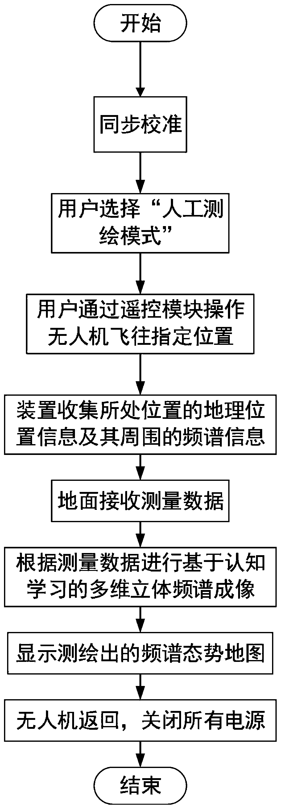
Embodiment 2
[0064] Embodiment 2: Taking the "manual surveying and mapping mode" task of spectrum situational awareness surveying and mapping based on the UAV platform as an example, the implementation process (see image 3 shown) as follows:
[0065]The first step, after completing the pre-startup inspection, select "manual surveying and mapping mode", and set the surveying and mapping parameters in the brain module 1-9 as shown in Table 2: the surveying and mapping antenna is an ultra-wideband passive omnidirectional antenna (frequency band is 20MHz—8GHz) , the mapping resolution is 10; the user operates the UAV from the starting point (118.796815, 31.93869) with a height of 120m through the remote control module 1-10, and reaches the end point (118.803681, 31.935922) with a height of 120m, so as to perform the three-dimensional spectrum of the path Situation mapping.
[0066] The specific process of remote control module 1-10 program-controlled UAV flight is as follows: remote control ...
PUM
 Abstract
Description
Claims
Application Information
 - R&D
- Intellectual Property
- Life Sciences
- Materials
- Tech Scout
- Unparalleled Data Quality
- Higher Quality Content
- 60% Fewer Hallucinations
Browse by: Latest US Patents, China's latest patents, Technical Efficacy Thesaurus, Application Domain, Technology Topic, Popular Technical Reports.
© 2025 PatSnap. All rights reserved.Legal|Privacy policy|Modern Slavery Act Transparency Statement|Sitemap|About US| Contact US: help@patsnap.com