Laser radar point cloud reflection intensity completion method and system

A reflection intensity, lidar technology, applied in radio wave measurement systems, image enhancement, use of re-radiation, etc., can solve the problems of little relationship between geometric information, insufficient accuracy of graphics segmentation labels, difficult to supervise labels, etc.

Active Publication Date: 2020-08-18
TSINGHUA UNIV
View PDF6 Cites 10 Cited by
  • Summary
  • Abstract
  • Description
  • Claims
  • Application Information

AI Technical Summary

Problems solved by technology

[0003] The existing methods are mainly aimed at the completion of point cloud depth information, but the completion of point cloud reflection intensity has some difficulties that depth estimation does not have: 1) The reflection intensity is related to the mate

Method used


Image

  • Laser radar point cloud reflection intensity completion method and system
  • Laser radar point cloud reflection intensity completion method and system
  • Laser radar point cloud reflection intensity completion method and system

Examples


Embodiment 2

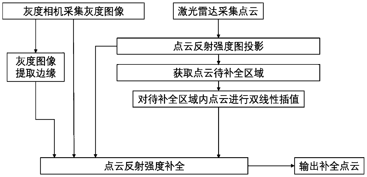
[0125] Such as Figure 4 As shown, Embodiment 2 of the present invention provides a laser radar point cloud reflection intensity complement system, including: the system includes a calibrated vehicle camera and laser radar, a grayscale image acquisition module, a laser radar point cloud acquisition module, Grayscale image edge extraction module, point cloud preprocessing module, trained point cloud reflection intensity completion model and point cloud reflection intensity completion module, wherein,

[0126] The grayscale image acquisition module is used to obtain a grayscale image through a calibrated vehicle camera;

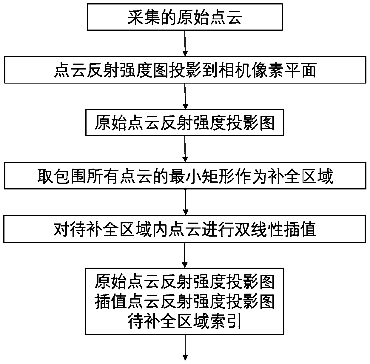
[0127] The laser radar point cloud acquisition module is used to obtain the original point cloud of the same road surface by laser radar;

[0128] The grayscale image edge extraction module is used to extract edge information of the grayscale image using a preset edge extraction strategy to obtain an edge image of the grayscale image;

[0129] The point cloud...


PUM


Abstract

The invention discloses a laser radar point cloud reflection intensity completion method and system, and the method comprises the steps: obtaining a gray image and an original point cloud of the sameroad surface through employing a calibrated vehicle-mounted camera and a laser radar; extracting edge information of the grayscale image by using a preset edge extraction strategy to obtain an edge image of the grayscale image; preprocessing the original point cloud to obtain an original point cloud reflection intensity projection image and an interpolation completion point cloud reflection intensity projection image; and inputting the grayscale image, the edge image of the grayscale image, the original point cloud reflection intensity projection image and the interpolation completion point cloud reflection intensity projection image into a pre-trained point cloud reflection intensity completion model, and outputting a completion point cloud reflection intensity projection image. Accordingto the point cloud reflection intensity completion method provided by the invention, the potential association between the point cloud and the image can be fully utilized, so that the reflection intensity image of the laser radar point cloud can be effectively and accurately completed.

Description

technical field [0001] The invention belongs to the technical field of intelligent driving, and in particular relates to a method and system for complementing reflection intensity of laser radar point clouds. Background technique [0002] Intelligent driving vehicles need to sense and measure the surrounding environment through lidar to ensure safe driving, including lane line detection, object detection and tracking, etc. However, the number of scanning lines of the lidar limits the density of the recorded point cloud, and the sparse point cloud is difficult to use for high-precision calculations, so it is necessary to complete the sparse point cloud into a dense point cloud. The main difficulties of point cloud completion include: 1) the original point cloud is too sparse; 2) outdoor scenes lack annotations for neural network supervised learning. [0003] The existing methods are mainly aimed at the completion of point cloud depth information, but the completion of point ...

Claims


Application Information

Patent Timeline
IPC IPC(8): G06T5/00G06V10/44
CPCG06T5/005G06T2207/10044G06T2207/20081G06T2207/20084G06T2207/30252G01S17/931G01S17/86G01S17/89G01S7/4808G06V20/647G06V20/56G06V10/44G06V10/757G06V10/803G06F18/251G06T7/13G06T7/70G01S17/894G06T2207/10028G06F18/2193
Inventor 张新钰李志伟刘华平邹镇洪李骏柯锐
Owner TSINGHUA UNIV
Why Eureka
Try Eureka