
A submarine navigation method and system based on a multi-dimensional gravity gradient lighthouse

A technology of gravity gradient and navigation method, applied in navigation, mapping and navigation, navigation calculation tools, etc., can solve the problems of decreased submarine safety, limited fluctuation of ocean gravity field, inability to match navigation with gravity lighthouse, etc. Effects of Safety and Accuracy

Active Publication Date: 2021-08-31
中国人民解放军61540部队 +1
View PDF2 Cites 0 Cited by
  • Summary
  • Abstract
  • Description
  • Claims
  • Application Information

AI Technical Summary

Problems solved by technology

[0003] However, gravity lighthouse navigation is limited by the fluctuation of the ocean's gravity field, and not every sea area can filter out gravity lighthouses
The gravity field changes smoothly in most areas, and gravity lighthouses cannot be used for matching navigation, so submarines can only use other "non-passive" auxiliary navigation methods, which reduces the safety of submarines

Method used


Image

  • A submarine navigation method and system based on a multi-dimensional gravity gradient lighthouse
  • A submarine navigation method and system based on a multi-dimensional gravity gradient lighthouse
  • A submarine navigation method and system based on a multi-dimensional gravity gradient lighthouse

Examples


Embodiment Construction

[0093] The following will clearly and completely describe the technical solutions in the embodiments of the present invention with reference to the accompanying drawings in the embodiments of the present invention. Obviously, the described embodiments are only some, not all, embodiments of the present invention. Based on the embodiments of the present invention, all other embodiments obtained by persons of ordinary skill in the art without making creative efforts belong to the protection scope of the present invention.

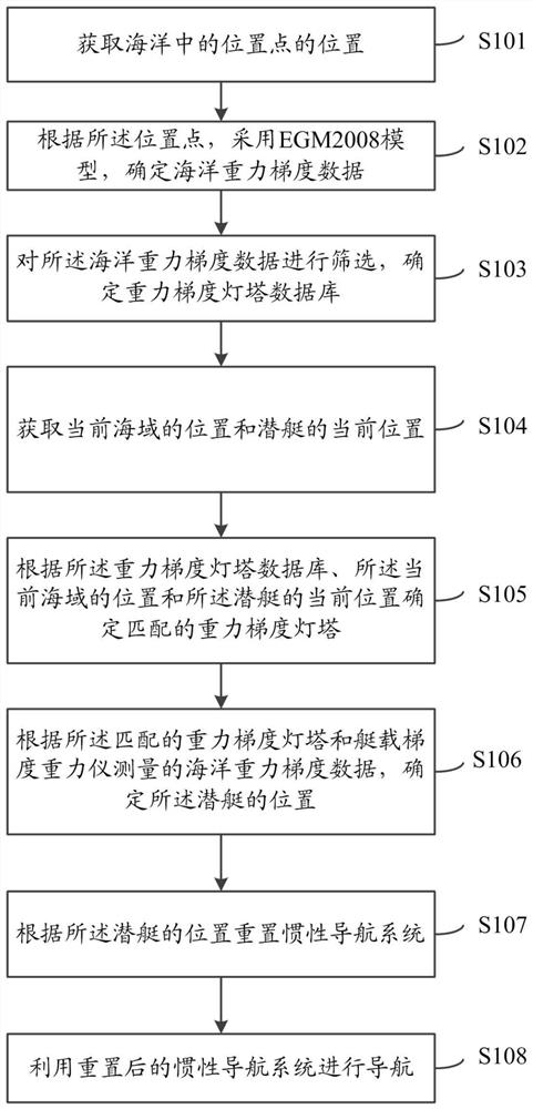
[0094] The purpose of the present invention is to provide a submarine navigation method and system based on a multi-dimensional gravity gradient lighthouse, which can improve the safety and accuracy of gravity lighthouse navigation in a flat gravity area.

[0095] In order to make the above objects, features and advantages of the present invention more comprehensible, the present invention will be further described in detail below in conjunction with the accomp...


PUM


Abstract

The invention relates to a submarine navigation method and system based on a multi-dimensional gravity gradient lighthouse. The method includes obtaining the position of a position point in the ocean; according to the position point, using a high-precision gravity field model to determine the ocean gravity gradient data; screening the ocean gravity gradient data to determine the gravity gradient lighthouse; acquiring the position of the current sea area and the submarine Determine the matching gravity gradient lighthouse according to the gravity gradient lighthouse database, the position of the current sea area and the current position of the submarine; determine the position of the submarine according to the ocean gravity gradient data measured by the matching gravity gradient lighthouse and the on-board gradient gravimeter; Reset the inertial navigation system based on the submarine's position. The invention provides a submarine navigation method and system based on a multi-dimensional gravity gradient lighthouse, which can improve the safety and accuracy of gravity lighthouse navigation in a gentle gravity area.

Description

technical field [0001] The invention relates to the field of underwater vehicle gravity navigation, in particular to a submarine navigation method and system based on a multi-dimensional gravity gradient lighthouse. Background technique [0002] The gravity lighthouse navigation method is to filter out the data with obvious characteristics from the global ocean gravity anomaly map, and construct the gravity lighthouse database. Correlation analysis is carried out between the measurement results of the boat-mounted gravimeter and the gravity lighthouse, so as to obtain its own coordinates and correct the inertial navigation system. [0003] However, gravity lighthouse navigation is limited by the ups and downs of the ocean's gravity field, and not every sea area can screen out gravity lighthouses. In most areas, the gravity field changes smoothly, and gravity lighthouses cannot be used for matching navigation, so submarines can only use other "non-passive" auxiliary navigati...

Claims


Application Information

Patent Timeline
Patent Type & Authority Patents(China)
IPC IPC(8): G01C21/20
CPCG01C21/20G01C21/203
Inventor 肖云任飞龙潘宗鹏刘晓刚
Owner 中国人民解放军61540部队
Learn More