Urban functional area identification method based on multi-subspace model

A technology of urban functions and identification methods, applied in the field of geospatial information identification, can solve the problems of limited feature mining, inability to describe functional areas concisely and accurately, and inaccurate clustering results.

Active Publication Date: 2020-09-11
CENT SOUTH UNIV
View PDF5 Cites 4 Cited by
  • Summary
  • Abstract
  • Description
  • Claims
  • Application Information

AI Technical Summary

Problems solved by technology

The strict assumption of the single subspace algorithm facilitates the acquisition of feature patterns, and the distribution of functional areas can be obtained by clustering according to the relationship between samples and features. However, if the weight of sample information is small, it will be marginalized after feature expression , resulting in inaccurate clustering results
And there are feature differences between functional areas, using the same set of features cannot describe each functional area concisely and precisely
When the data is too large and the feature pattern is too complex, the assumption of the feature pattern of the single subspace model will limit the mining of features
so they cannot handle more complex data
[0006] Second, these models ignore the geometric meaning of the vector space
The geometric properties of the subspace are related to the characteristics of the urban functional area, and the existing technology ignores the discussion and consideration of this

Method used


Image

  • Urban functional area identification method based on multi-subspace model
  • Urban functional area identification method based on multi-subspace model
  • Urban functional area identification method based on multi-subspace model

Examples


Embodiment Construction

[0051] The present invention will be further described below in conjunction with the embodiments and accompanying drawings, but the present invention is not limited in any way. Any transformation or replacement based on the teaching of the present invention belongs to the protection scope of the present invention.

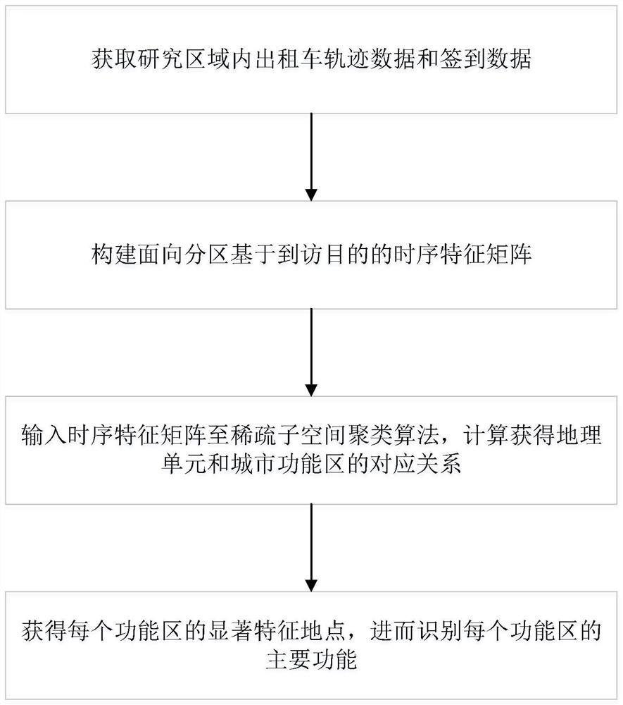
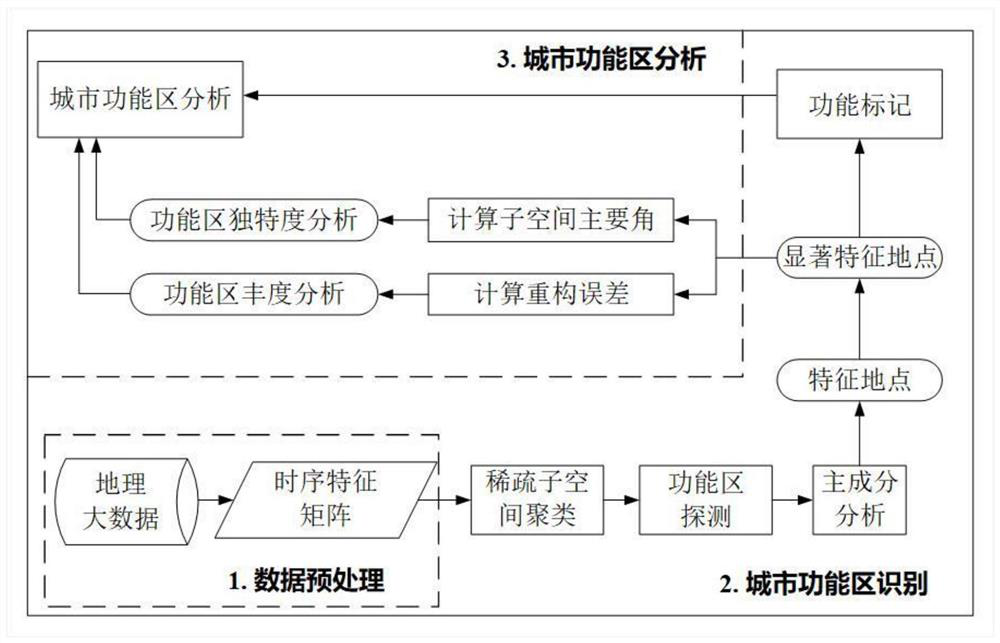
[0052] Such as figure 1 As shown, a method for identifying urban functional areas based on a multi-subspace model includes the following steps:

[0053] Step 1. Obtain taxi trajectory data and check-in data in the research area;

[0054] Step 2, constructing a partition-oriented timing feature matrix C based on the purpose of visit;

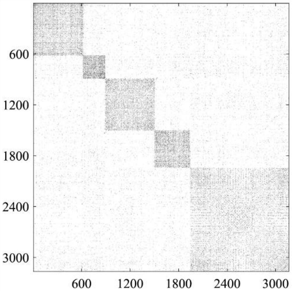
[0055] Step 3, input the time-series feature matrix C into the sparse subspace clustering algorithm, and calculate the corresponding relationship between geographical units and urban functional areas;

[0056] Step 4. Obtain the prominent feature locations of each functional area, and then identify the main functions of each functio...


PUM


Abstract

The invention discloses an urban functional area identification method based on a multi-subspace model. The method comprises the following steps: obtaining taxi track data and sign-in data in a research area; constructing a partition-oriented time sequence feature matrix C based on a visiting purpose; inputting the time sequence characteristic matrix C to a sparse subspace clustering algorithm, and calculating and obtaining a corresponding relationship between the geographic unit and the urban functional area; and obtaining a significant feature location of each functional area, and further identifying a main function of each functional area. According to the method, human activity information provided by geographic big data is utilized; the model based on the multiple subspaces overcomesthe defects in the prior art, can recognize the urban functional areas more accurately, analyzes the uniqueness and abundance of each functional area based on the geometrical properties of the subspaces, and provides fine quantitative index indication for the management and development of the urban functional areas.

Description

technical field [0001] The invention belongs to the technical field of geographic space information identification, and relates to an identification method of urban geographical information, in particular to an identification method of urban functional areas based on a multi-subspace model. Background technique [0002] Urban spatial structure is a core research content of urban geographic information science, and it is also a concentrated reflection of the relationship between man and land, because urban space has an impact on human production and activities when it is affected by human activities, and it involves urban planning and site selection. , as small as travel and location recommendations. In the analysis of urban spatial structure, the distribution of urban functional areas is the result presented in geographical space under the influence of many factors. [0003] There are many methods for analyzing urban functional areas, such as social surveys, but it takes ti...

Claims


Application Information

Patent Timeline
Patent Type & Authority Applications(China)
IPC IPC(8): G06F16/2458G06F16/29G06K9/62
CPCG06F16/2462G06F16/29G06F18/23213
Inventor 朱佳玮陶超李海峰肖俊
Owner CENT SOUTH UNIV
Why Eureka
Try Eureka