Dual-mode GNSS carrier precise single-point positioning method and system for intelligent terminal

A precise single-point positioning and intelligent terminal technology, applied in the field of satellite navigation, can solve problems such as insufficient reference station density, non-common-mode error satellite orbit error cannot be completely eliminated, and short baseline cannot be guaranteed.

Pending Publication Date: 2020-10-30
SHANGHAI JIAO TONG UNIV
View PDF0 Cites 9 Cited by
  • Summary
  • Abstract
  • Description
  • Claims
  • Application Information

AI Technical Summary

Problems solved by technology

However, there are still certain limitations in differential positioning. For example, in the case of long baselines (for example, the density of reference stations in non-urban areas is not enough to en...

Method used


Image

  • Dual-mode GNSS carrier precise single-point positioning method and system for intelligent terminal
  • Dual-mode GNSS carrier precise single-point positioning method and system for intelligent terminal
  • Dual-mode GNSS carrier precise single-point positioning method and system for intelligent terminal

Examples


Embodiment Construction

[0108] The present invention will be described in detail below in conjunction with specific embodiments. The following examples will help those skilled in the art to further understand the present invention, but do not limit the present invention in any form. It should be noted that those skilled in the art can make several changes and improvements without departing from the concept of the present invention. These all belong to the protection scope of the present invention.

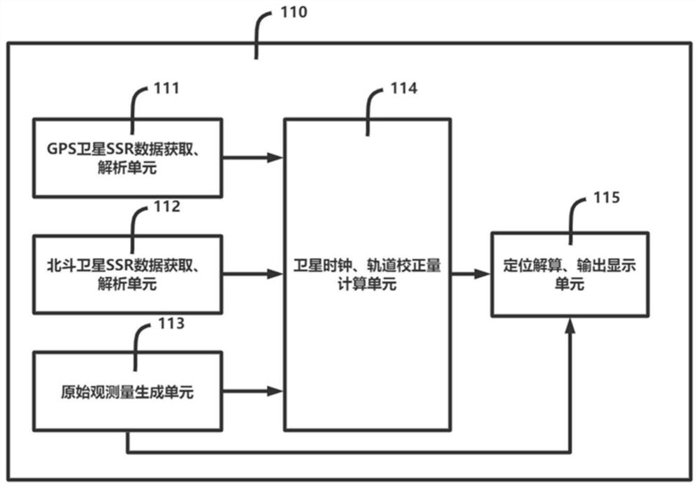
[0109] A dual-mode GNSS carrier precise single-point positioning method for an intelligent terminal provided according to the present invention includes:

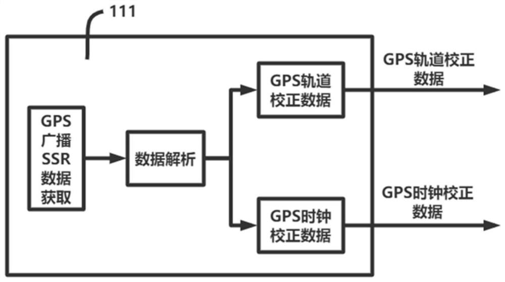
[0110] Step S1: At each epoch time, the GPS satellite SSR data acquisition and analysis unit (111) is responsible for receiving the real-time SSR data of the GPS satellite, and converting the binary bit stream into a preset format by analyzing the data information in the navigation message broadcast by the satellite. Converted to the parameters of th...


PUM


Abstract

The invention provides a dual-mode GNSS carrier precision single-point positioning method and system for an intelligent terminal. The system comprises a GPS satellite SSR data acquisition and analysisunit (111), a Beidou satellite SSR data acquisition and analysis unit (112), an original observed quantity generation unit (113), a satellite clock, an orbit correction value calculation unit (114) and a positioning calculation and output display unit (115). According to the method, the SSR data of the GPS and Beidou dual-mode system is used for enhancement, the number of satellites is large, theconvergence rate of carrier phase ambiguity calculation is high, and the positioning precision is high and stable.

Description

technical field [0001] The invention relates to the field of satellite navigation, in particular to a dual-mode GNSS carrier precise single-point positioning method and system for an intelligent terminal. In particular, it relates to a dual-mode GNS precise point positioning method for portable smart devices based on satellite-based augmentation technology. Background technique [0002] In order to meet the needs of mobile positioning, today's portable smart devices (such as smart phones, tablet computers, etc.) generally integrate a global navigation satellite system (GNSS) module, so as to realize outdoor positioning and navigation functions based on satellite signals. At present, most of the satellite positioning methods based on portable smart devices are based on pseudo-range observations, and eliminate or weaken various time delays and error effects in pseudo-ranges through differential, satellite broadcast, or empirical model formulas, such as ionospheric time Delay,...

Claims


Application Information

Patent Timeline
IPC IPC(8): G01S19/44
CPCG01S19/44
Inventor 戴振东文飞武子达刘强应忍冬刘佩林
Owner SHANGHAI JIAO TONG UNIV
Why Eureka
Try Eureka