
Eureka
For R&D, Eureka makes reading and utilizing patents & technical documents easy.
Eureka AIR
Designed for self-driven R&D workflows. Generate viable solutions, solve complex R&D challenges, empower your innovation with AI.

Eureka Materials
Designed for material experts only. Revolutionize your material R&D, from search, analyze, to developing new materials.

TechResearch
Generate reliable direction feasibility study reports for your R&D in just a few steps.

TechSeek
Discover and master advanced knowledge NOW. Basics, ideas, possibilities, all at once.

TechMind
As an expert in R&D Theories, TechMind can generates customized viable solutions instantly.

TechRisk
Analyze your overall solution with one click, know your potential R&D risks in advance.

TechMonitor
Get weekly tech updates, stay abreast of the latest tech innovations and key insights.
Outdoor running route navigation system and method based on LBS positioning and route marking
A technology of navigation system and navigation method, which is applied in the directions of navigation, surveying and navigation, navigation calculation tool, etc.
- Summary
- Abstract
- Description
- Claims
- Application Information
AI Technical Summary
Problems solved by technology
Method used
Image

Examples
Embodiment 1
[0067] The outdoor running route navigation system based on LBS positioning and route labeling of the present invention, the system includes:
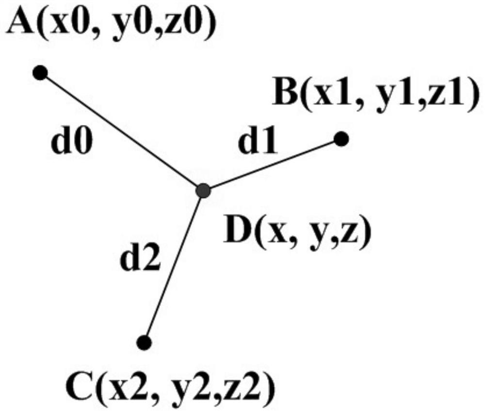
[0068] The LBS positioning module is used to use mobile devices (such as mobile phones) to obtain the current position of the user through LBS positioning and the radio communication network (such as GSM network, CDMA network) of the telecommunications mobile operator using a triangular relationship; as attached figure 2 As shown, the details are as follows:
[0069] It is abstracted into the following problem: given the coordinates of three points A, B, and C, and the distances from the three points to point D (respectively d0, d1, d2), find the coordinates of point D. The following formula (Formula 1) can be listed, three equations and three unknowns can find a unique solution.
[0070]
[0071] Among them, ABC is the base station location preset by mobile telecommunications, d0, d1, and d2 are the distances between the mobile d...
Embodiment 2
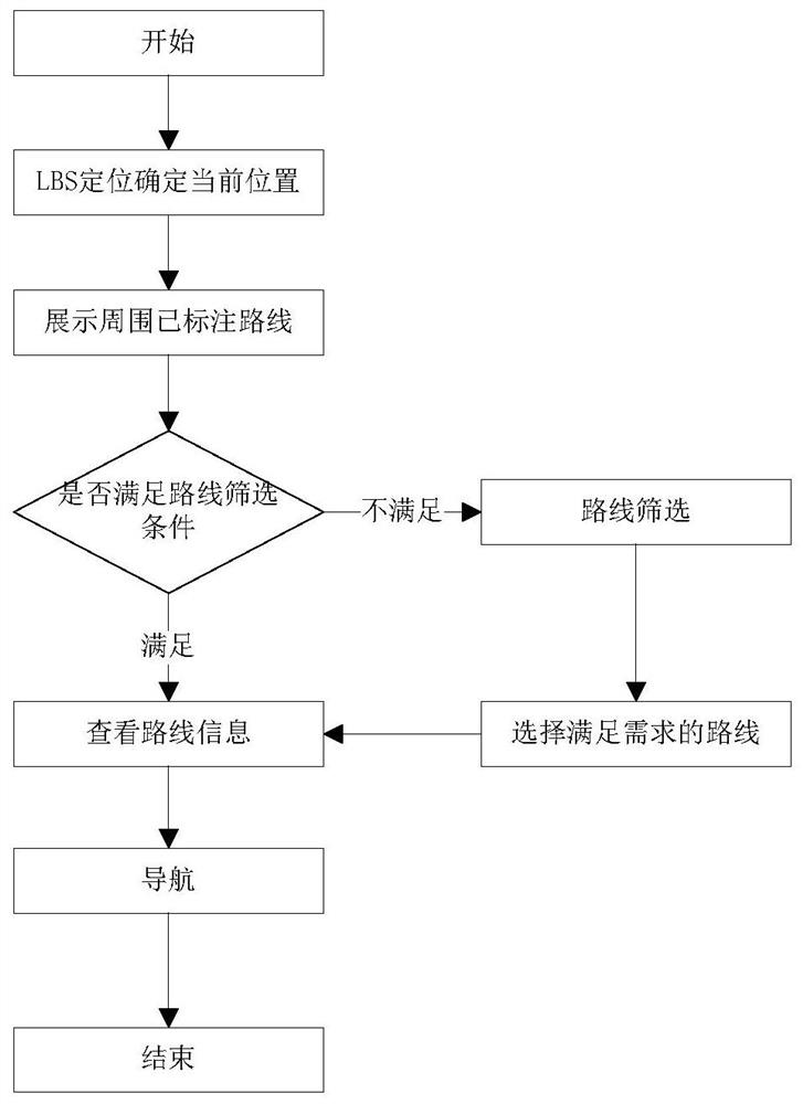
[0087] as attached figure 1 As shown, the outdoor running route navigation method based on LBS positioning and route labeling of the present invention, the method is specifically as follows:
[0088] S1. Obtain the location of the user, based on the current location of the user;
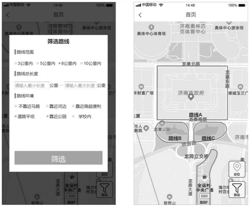
[0089] S2, displaying on the map the routes marked around it that are suitable for outdoor running;
[0090] S3. Judging whether the displayed marked route meets the user's needs:
[0091] ①, if satisfied, then execute step S4;
[0092] ②. If it is not satisfied, the user will filter the route according to the displayed route, select the route that meets his own conditions as the outdoor running route, and then perform step S4;
[0093] S4. Check route information;
[0094] S5. Turn on the navigation, and start running outdoors according to the route planning displayed by the navigation.
[0095] Among them, the screening conditions of the route screening module include the route range, the tota...
Embodiment 3
[0105] An embodiment of the present invention also provides an electronic device, including: a memory and at least one processor;
[0106] Wherein, the memory stores computer-executable instructions;
[0107] The at least one processor executes the computer-executed instructions stored in the memory, so that the at least one processor executes the outdoor running route navigation method based on LBS positioning and route labeling as in Embodiment 2.
PUM
 Abstract
Description
Claims
Application Information
 - R&D Engineer
- R&D Manager
- IP Professional
- Industry Leading Data Capabilities
- Powerful AI technology
- Patent DNA Extraction
Browse by: Latest US Patents, China's latest patents, Technical Efficacy Thesaurus, Application Domain, Technology Topic, Popular Technical Reports.
© 2024 PatSnap. All rights reserved.Legal|Privacy policy|Modern Slavery Act Transparency Statement|Sitemap|About US| Contact US: help@patsnap.com