Supercharge Your Innovation With Domain-Expert AI Agents!

Base station surveying and mapping method and device, computer readable storage medium and electronic device

A storage medium and computer technology, applied in the field of navigation, to achieve the effect of efficient and accurate surveying and mapping

Pending Publication Date: 2020-11-03
黄珊
View PDF0 Cites 0 Cited by
  • Summary
  • Abstract
  • Description
  • Claims
  • Application Information

AI Technical Summary

Problems solved by technology

[0005] Embodiments of the present invention provide a base station surveying and mapping method and device, a computer-readable storage medium, and an electronic device to at least solve a series of problems in the related art when the UWB positioning system performs surveying and mapping of base stations

Method used


Image

  • Base station surveying and mapping method and device, computer readable storage medium and electronic device
  • Base station surveying and mapping method and device, computer readable storage medium and electronic device
  • Base station surveying and mapping method and device, computer readable storage medium and electronic device

Examples


Embodiment 1

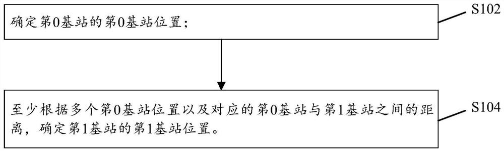
[0034] An embodiment of the present invention provides a base station surveying and mapping method, which is applied to a UWB positioning system, and the UWB positioning system includes a plurality of base stations; figure 1 It is a flow chart (1) of a base station surveying and mapping method provided according to an embodiment of the present invention, such as figure 1 As shown, the base station surveying and mapping method in the embodiment of the present invention includes:

[0035] S102. Determine the position of the 0th base station of the 0th base station;

[0036] S104. Determine a first base station position of the first base station at least according to multiple zeroth base station positions and corresponding distances between the zeroth base station and the first base station.

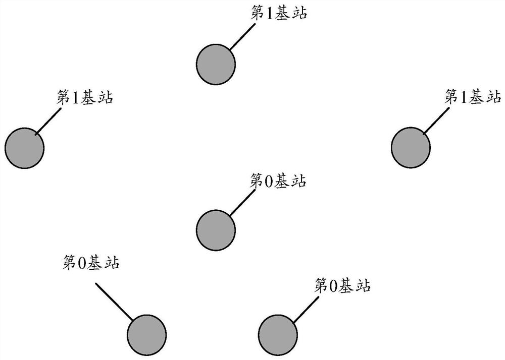
[0037] It should be noted that the UWB positioning system in the embodiment of the present invention may include multiple 0th base stations, figure 2 It is a schematic distribution diagr...

Embodiment 2

[0120] The embodiment of the present invention also provides a base station surveying and mapping method, Figure 5 It is the flow chart (2) of the base station surveying and mapping method provided according to the embodiment of the present invention, such as Figure 5 As shown, the base station surveying and mapping method in the embodiment of the present invention includes:

[0121] S202, broadcast the first data frame through the target base station, and receive the third data frame broadcast by the preset label through the target base station; wherein, the third data frame carries the label position of the label;

[0122] S204. Determine the target tag distance according to the first data frame and the third data frame; wherein, the target tag distance is used to indicate the distance between the target base station and the tag;

[0123] S206. Determine a target base station position of the target base station according to target tag distances between multiple tag positi...

Embodiment 3

[0132] The embodiment of the present invention also provides a base station surveying and mapping device, which is set in a UWB positioning system, and the UWB positioning system includes a plurality of base stations. The device is used to implement the above-mentioned embodiments and preferred implementation modes, and what has been described will not be repeated. As used below, the term "module" may be a combination of software and / or hardware that realizes a predetermined function. Although the devices described in the following embodiments are preferably implemented in software, implementations in hardware, or a combination of software and hardware are also possible and contemplated.

[0133] Figure 6 It is a structural block diagram (1) of a base station surveying and mapping device provided according to an embodiment of the present invention, such as Figure 6 As shown, the base station surveying and mapping device in the embodiment of the present invention includes: ...


PUM


Abstract

The invention provides a base station surveying and mapping method and device, a computer readable storage medium and an electronic device, and the base station surveying and mapping method comprisesthe steps: determining the position of a zeroth base station of the zeroth base station; and determining the first base station position of the first base station at least according to the plurality of zero base station positions and the corresponding distance between the zero base station and the first base station. Therefore, the embodiments of the present invention can solve a series of problems existing when a UWB positioning system maps a base station in the related art, so as to achieve an effect of efficiently realizing accurate mapping of the base station.

Description

technical field [0001] The present invention relates to the field of navigation, in particular, to a base station surveying and mapping method and device, a computer-readable storage medium, and an electronic device. Background technique [0002] The ultra-wideband (Ultra Wide Band, UWB) positioning system in the related art realizes the positioning process through the communication interaction between multiple base stations in the system and the tags performing positioning; specifically, the base station sends data frames to the tags After positioning, the tag needs to return a data frame to the base station, so that the base station can know the relative position of the tag and the base station, and perform the above operations through multiple base stations with known positions, and then realize the positioning of the tag. [0003] In order to realize the above-mentioned positioning operation, the position of the base station needs to be determined in advance. Therefore, ...

Claims


Application Information

Patent Timeline
Patent Type & Authority Applications(China)
IPC IPC(8): H04W4/02H04W64/00
CPCH04W4/023H04W64/003
Inventor 黄珊
Owner 黄珊
Features
  • R&D
  • Intellectual Property
  • Life Sciences
  • Materials
  • Tech Scout
  • Unparalleled Data Quality
  • Higher Quality Content
  • 60% Fewer Hallucinations
Learn More