Offline map matching method

A matching method and offline map technology, which can be used in radio wave measurement systems, satellite radio beacon positioning systems, measurement devices, etc., and can solve the problems of low matching efficiency and low matching accuracy.

Active Publication Date: 2020-12-04
SICHUAN UNIV
View PDF19 Cites 4 Cited by
  • Summary
  • Abstract
  • Description
  • Claims
  • Application Information

AI Technical Summary

Problems solved by technology

[0005] The main purpose of the present invention is to propose an offline map matching method to solve the problems of low matching accuracy and low matching efficiency of the map matching method for low sampling frequency trajectory data in the prior art

Method used


Image

  • Offline map matching method
  • Offline map matching method
  • Offline map matching method

Examples


Embodiment 1

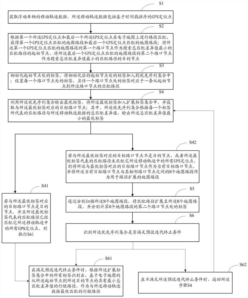
[0067] Such as figure 1 As shown, the embodiment of the present invention provides an offline map matching method, figure 1 It exemplarily shows its implementation steps, including:

[0068] S1. Acquire movement track data of the floating vehicle, where the movement track data includes GPS positioning points sorted based on time stamps.

[0069] In the above step S1, when offline map matching is not performed, the movement trajectory data generated when the floating vehicle moves generally has positioning errors, that is, each GPS positioning point in the movement trajectory data cannot be well aligned with the vehicle on the electronic map. The road segments of the maps that are actually driven are matched, for example, the projections of the two cannot overlap.

[0070] S2. Carry out road segment matching on the electronic map according to the first GPS positioning point and the last GPS positioning point, and obtain the map road segment matched by the first GPS positionin...

Embodiment 2

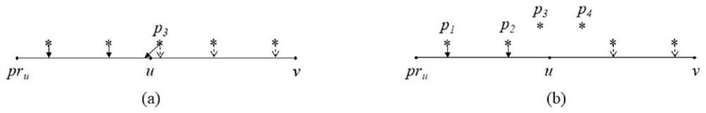
[0098] The embodiment of the present invention is used for supplementary description of step S5 in the foregoing embodiment. In the above step S5, if only based on the distance limit of 40 meters, the initially matched GPS positioning point with the scanned map road section may be controversial. Therefore, in the embodiment of the present invention, the GPS positioning point that has matching disputes is also identified and corrected. And calculate the matching difference between the corrected GPS positioning point and the scanned map road segment, so as to accurately calculate the label at the second intersection node of the scanned map road segment.

[0099] Therefore, in the embodiment of the present invention, in the above step S5, before obtaining the GPS positioning point that initially matches the scanned m-th map road segment, it is first necessary to define the scanned map road segment, including:

[0100] Define the starting node as s, the scanned map road section as...


PUM


Abstract

The invention is applicable to the technical field of offline map matching, and provides an offline map matching method. The method models an offline map matching problem into a shortest path problemtaking minimization of a total matching difference value between moving track data and a matching path as an optimization target, so that on one hand, the problem of arc crossing in offline map matching is solved, and on the other hand, the problem of arc crossing in offline map matching is solved; on the other hand, compared with an incremental matching method which only considers the informationof the adjacent GPS positioning points or the adjacent track segments to match the current GPS positioning points or the track segments, the offline map matching method provided by the embodiment ofthe invention has the advantages that a driving path with the minimum total matching difference value with the moving track data is found from the global perspective, a high matching precision is obtained, and in the process, a plurality of candidate matching positions do not need to be set for each GPS positioning point, and only one shortest path from the starting node to the destination node needs to be calculated, so that compared with a global maximum weight matching method, the method of the invention omits a large amount of shortest path calculation and greatly improves the map matchingefficiency.

Description

technical field [0001] The invention relates to the technical field of offline map matching, in particular to an offline map matching method. Background technique [0002] Embedding Global Positioning System (GPS) enabled devices into floating vehicles has become very popular over the past few years. This allows the traffic management department to collect a large amount of movement trajectory data reflecting the real-time position, speed and direction of the vehicle. In intelligent transportation systems, these mobile trajectory data usually need to be integrated with geographic information systems to provide various services for individuals or companies, such as vehicle navigation and reappearing vehicle driving routes. In the integration with GIS, a key operation is to match the movement trajectory data with the road network topology data to identify the specific road segments and driving paths driven by vehicles, which is called "map matching". Efficient map matching c...

Claims


Application Information

Patent Timeline
Patent Type & Authority Applications(China)
IPC IPC(8): G01C21/30G01S19/39G01S19/42
CPCG01C21/30G01S19/393G01S19/42Y02T10/40
Inventor 郭钊侠张冬青郭丰刘琦杨靖
Owner SICHUAN UNIV
Why Eureka
Try Eureka