Construction method of remote sensing image classification model and remote sensing image classification method and system

A technology of remote sensing image and construction method, which is applied in the field of remote sensing image classification method and system, and the construction field of remote sensing image classification model, which can solve problems such as misclassification, low classification accuracy, and salt and pepper phenomenon, so as to improve classification accuracy and improve boundary approximation The degree of fit and the effect of solving the difficulty of scale selection

Active Publication Date: 2020-12-04
CHANGAN UNIV
View PDF14 Cites 1 Cited by
  • Summary
  • Abstract
  • Description
  • Claims
  • Application Information

AI Technical Summary

Problems solved by technology

[0004] In view of the deficiencies and defects of the above-mentioned prior art, the object of the present invention is to provide a method for constructing a remote sensing image classification model, a remote sensing image classification method and system, and solve the problems in the classification of high-resolution remote sensing images in complex scenes in the prior art. , low classification accuracy, salt and pepper phenomenon and serious misclassification problems

Method used


Image

  • Construction method of remote sensing image classification model and remote sensing image classification method and system
  • Construction method of remote sensing image classification model and remote sensing image classification method and system
  • Construction method of remote sensing image classification model and remote sensing image classification method and system

Examples


Embodiment 1

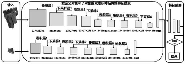
[0064] A method for building a remote sensing image classification model, the method for building is:

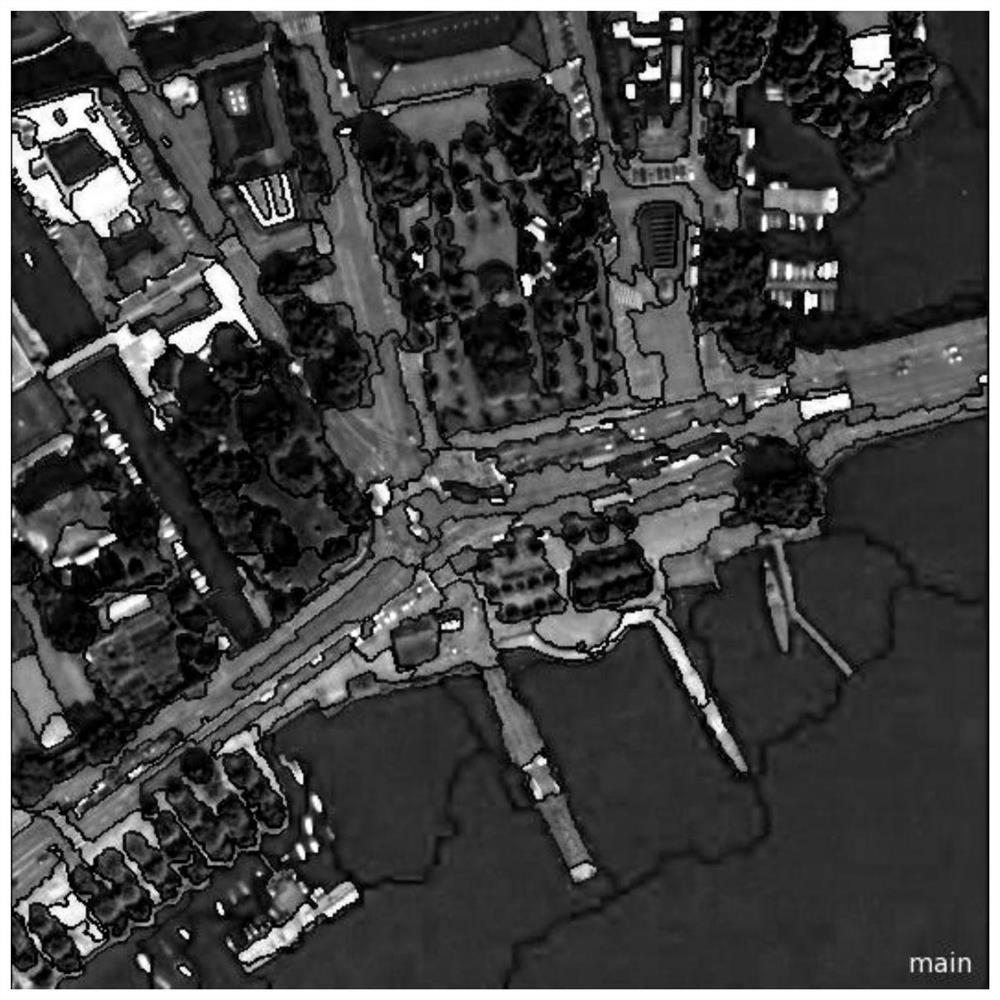
[0065] Step 1: Collect high-resolution remote sensing images to obtain high-resolution remote sensing images; the high-resolution remote sensing images selected in this example are 0.61m-resolution images of the city of Zurich acquired by Quick Bird in 2002, with an image size of 531×531. The bands include blue, green, red, and near-infrared bands, and the types of ground features include water bodies, shadows, vegetation, houses, roads, and boats.

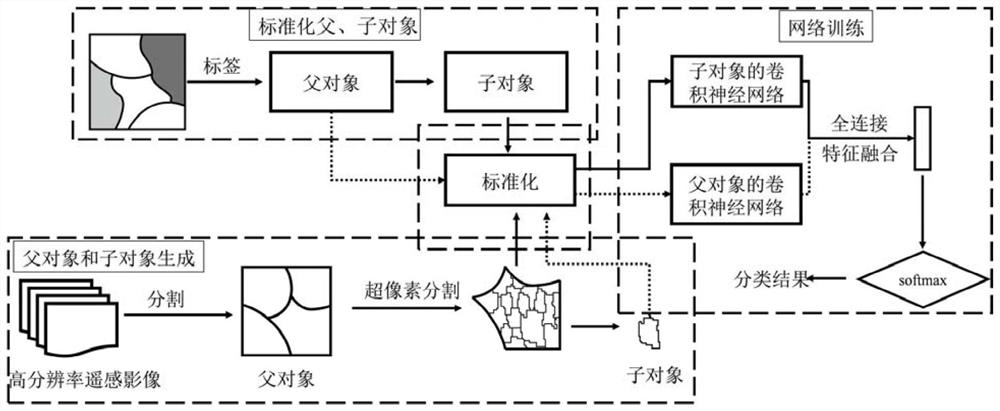
[0066] Step 2: mark the above-mentioned high-resolution remote sensing image features, obtain a marked sample set, segment the obtained marked sample set to obtain a parent object, and segment the parent object to obtain a child object;

[0067] Step 2.1, labeling the object types of the high-resolution remote sensing image, obtaining the labeled high-resolution remote sensing image, and obtaining the label set;

[0068] Step 2...


PUM


Abstract

The invention provides a construction method of a remote sensing image classification model, a remote sensing image classification method and a remote sensing image classification system. The method comprises the steps of 1, collecting a high-resolution remote sensing image; 2, labeling the high-resolution remote sensing image to obtain a high-resolution remote sensing image with labels, obtaininga label set, segmenting the obtained high-resolution remote sensing image with labels to obtain a parent object, and segmenting the parent object to obtain a child object; 3, standardizing the parentobject and the child object obtained in the step 2, and dividing the standardized parent object and child object into a training sample set, a verification set and a test sample set; and 4, constructing a convolutional neural network model based on the parent object and the child object; and classifying the high-resolution remote sensing images by using a network model. Refined classification ofgeographic entities is realized, and the problems of low classification precision, salt and pepper phenomena and serious wrong classification in classification of high-resolution remote sensing imagesin a complex scene are solved.

Description

technical field [0001] The invention belongs to the field of remote sensing and digital image processing, and relates to high-resolution remote sensing image classification, in particular to a method for constructing a remote sensing image classification model, a remote sensing image classification method and a system. Background technique [0002] With the development of remote sensing sensors and imaging technology, the resolution of remote sensing images is getting higher and higher. Classification of high-resolution remote sensing images is a key issue in the analysis and application of satellite image data. Deep learning, by extracting more abstract features layer by layer from the input data from the low level to the high level, forms a network weight structure that is most suitable for the required features, thereby improving the accuracy of classification and enabling the classification model to have classification generalization capabilities. Among them, convolutio...

Claims


Application Information

Patent Timeline
Patent Type & Authority Applications(China)
IPC IPC(8): G06K9/00G06K9/62G06N3/04G06N3/08
CPCG06N3/08G06V20/13G06N3/045G06F18/232G06F18/214
Inventor 韩玲李良志罗林涛王刘华赵永华刘志恒
Owner CHANGAN UNIV
Why Eureka
Try Eureka