
High-altitude parabolic detection method based on spatio-temporal information

A high-altitude parabolic and detection method technology, which is applied in the direction of neural learning methods, biological neural network models, instruments, etc., can solve the problems of inability to accurately detect, prevent and warn high-altitude parabolic objects, and have many false detections and false alarms. Convenience, fast running speed, resistance to the effect of light changes

Active Publication Date: 2021-02-02
ANHUI TSINGLINK INFORMATION TECH
View PDF19 Cites 9 Cited by
  • Summary
  • Abstract
  • Description
  • Claims
  • Application Information

AI Technical Summary

Benefits of technology

This patented technology uses spatially correlated data from multiple cameras or sensors attached to spacecraft during flight for accurate tracking purposes. It does this through analyzing image frames captured over different periods of time with each other's movement. By comparing these movements across consecutive scenes, we are able to determine if someone falls down onto them correctly without being affected by any external factors like sunlight shading or rain streaks. Additionally, our system takes into account both temporal variations caused by moving targets themselves (their altitudes) and environmental variables such as weather conditions. Overall, its technical effect lies within improving accuracy and reliability while minimizing complexity and cost compared to existing methods used today.

Problems solved by technology

Technological Problem: Current methods for identifying high-height object(es) (such as birds or debris), which can cause injury during flight due to their ability to hide under trees without being seen by aircraft pilots. These techniques require expensive cameras installed near airports, making them hard targets against terrorists who may be able to disable these systems before they enter into action. Additionally, current technologies rely heavily upon visual inspeckling to identify threatening events caused by such objects.

Method used


Image

  • High-altitude parabolic detection method based on spatio-temporal information
  • High-altitude parabolic detection method based on spatio-temporal information
  • High-altitude parabolic detection method based on spatio-temporal information

Examples


Embodiment Construction

[0049] In the following, the technical solution of the present invention will be described in detail through specific embodiments, and many specific details are set forth in the following description so as to fully understand the present invention. However, the present invention can be implemented in many other ways different from those described here, and those skilled in the art can make similar improvements without departing from the connotation of the present invention, so the present invention is not limited by the specific implementation disclosed below.

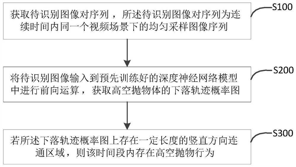
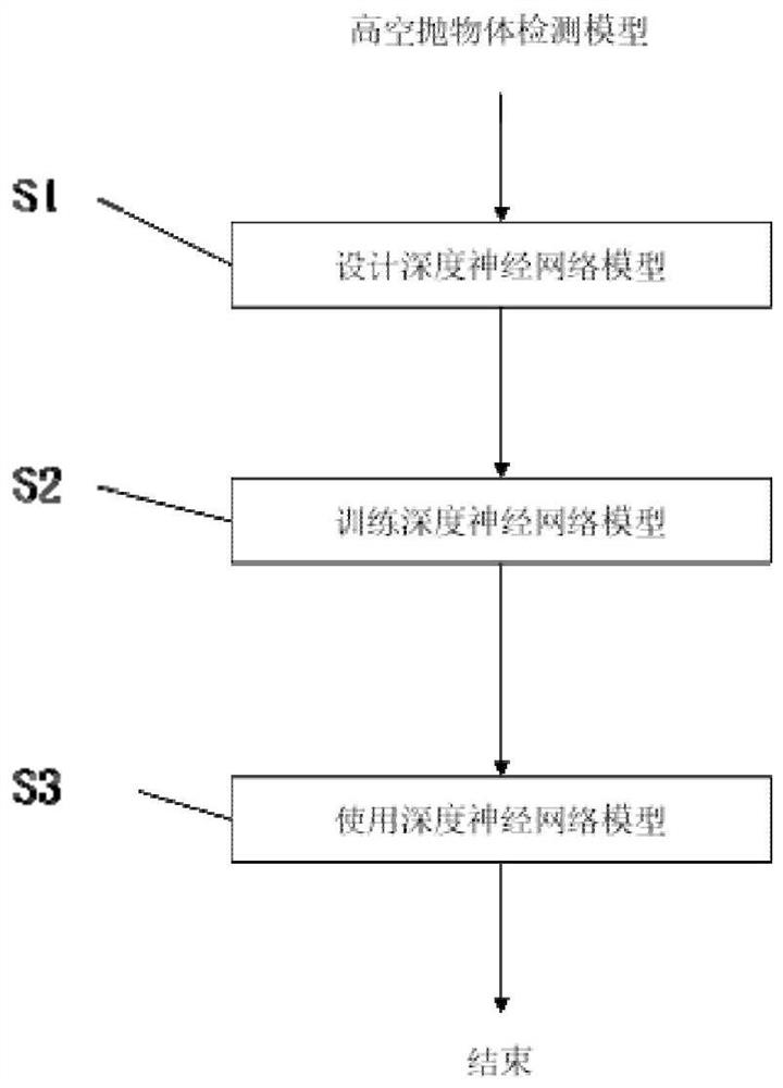
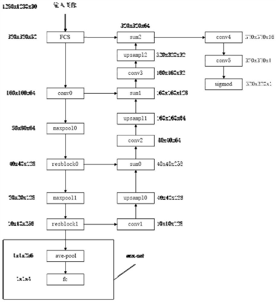
[0050] Such as Figures 1 to 6 As shown, a kind of high-altitude parabolic detection method based on space-time information proposed by the present invention includes steps S100 to S300:

[0051] S100: Obtain a sequence of image pairs to be recognized, where the sequence of image pairs to be recognized is a sequence of uniformly sampled images in the same video scene within a set time;

[0052] S100: Input the image p...


PUM


Abstract

The invention discloses a high-altitude parabolic detection method based on spatio-temporal information, and the method comprises the steps: obtaining a to-be-recognized image pair sequence which is auniform sampling image sequence in the same video scene in continuous time; inputting the to-be-recognized image pair sequence into a pre-trained deep neural network model for forward operation, andobtaining a falling track probability graph of the high-altitude projectile body; if the falling track probability graph has a vertical communication area with a certain length, determining that a high-altitude parabolic behavior exists in the time period. The falling track of the high-altitude projectile body can be accurately positioned, and then whether the high-altitude projectile behavior exists or not is judged.

Description


Claims


Application Information

Patent Timeline
Owner ANHUI TSINGLINK INFORMATION TECH
Learn More