Satellite-borne iGNSS-R height measurement precision evaluation method

An accuracy evaluation, on-board technology, applied in the field of satellite altimetry

Pending Publication Date: 2021-02-12
CHINA ACADEMY OF SPACE TECHNOLOGY
View PDF5 Cites 2 Cited by
  • Summary
  • Abstract
  • Description
  • Claims
  • Application Information

AI Technical Summary

Problems solved by technology

However, the scanning loss error model of the antenna directivity coefficient applicable to the spaceborne iGNSS-R sea surface altimetry scene has not yet been established to analyze the impact of scanning loss on the altimetry performance estimation

Method used


Image

  • Satellite-borne iGNSS-R height measurement precision evaluation method
  • Satellite-borne iGNSS-R height measurement precision evaluation method
  • Satellite-borne iGNSS-R height measurement precision evaluation method

Examples


Embodiment Construction

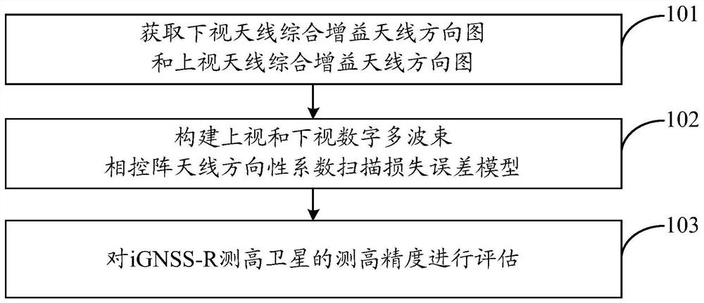
[0068] In order to make the object, technical solution and advantages of the present invention clearer, the embodiments disclosed in the present invention will be further described in detail below in conjunction with the accompanying drawings.

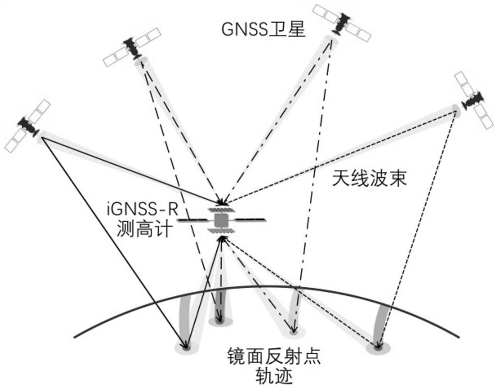
[0069] When the iGNSS-R (interferometric Global Navigation Satellite System Reflectometry) altimetry satellite receives the direct and reflected signals through the digital multi-beam phased array antenna, the taper of the feed will cause the scanning loss of the directivity coefficient. If this factor is ignored, the iGNSS-R measurement High-precision evaluation will produce bias, which in turn will cause wrong reference to load design.

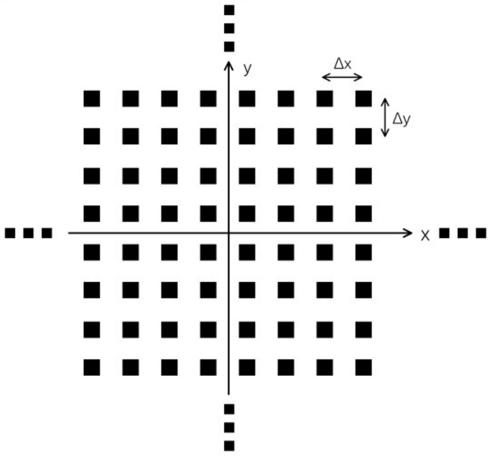
[0070] The directivity coefficient is an important parameter that affects the high-precision estimation of iGNSS-R measurement. The directivity coefficient scanning loss error model can more accurately estimate the directivity coefficient of the up / down-looking antenna of the iGNSS-R altimeter at diff...


PUM


Abstract

The invention discloses a satellite-borne iGNSS-R height measurement precision evaluation method. The method comprises the steps of acquiring comprehensive gain antenna directional diagrams of a downward-looking antenna and an upward-looking antenna; constructing an iGNSS-R height measurement satellite upward-looking and downward-looking digital multi-beam phased array antenna directivity coefficient scanning loss error model according to the acquired downward-looking and upward-looking antenna comprehensive gain antenna directional diagrams; and evaluating the height measurement precision ofthe iGNSS-R height measurement satellite according to the constructed scanning loss error model of the directivity coefficients of the upward-looking and downward-looking digital multi-beam phased array antennas of the iGNSS-R height measurement satellite. In order to improve the estimation precision of iGNSS-R sea surface height measurement, the directivity coefficient scanning loss error model suitable for a satellite-borne iGNSS-R sea surface height measurement scene is established for the first time, and directivity coefficient scanning losses of the up-looking digital multi-beam phased array antenna and the down-looking digital multi-beam phased array antenna at different satellite altitude angles are obtained; and by applying the model, the iGNSS-R height measurement precision is improved by more accurately estimating the signal-to-noise ratio.

Description

technical field [0001] The invention belongs to the technical field of satellite altimetry, and in particular relates to a high-precision evaluation method for satellite-borne iGNSS-R surveying. Background technique [0002] GNSS-R (Global Navigation Satellite System Reflectometry) sea surface altimetry, as a new earth observation technology that organically integrates satellite navigation and remote sensing, can significantly improve mesoscale ocean height models. Since Martin-Neira first proposed the concept of PARIS (PAssive Reflectometry and Interferometric System) in 1993, the feasibility of GNSS-R sea surface altimetry technology has been verified on shore-based, airborne, space-borne and other observation platforms, further improving the accuracy of measurement is the key to promoting its application. High-precision GNSS-R sea surface altimetry data can effectively improve the inversion accuracy of ocean physical models, and is of great significance for fine-grained ...

Claims


Application Information

Patent Timeline
Patent Type & Authority Applications(China)
IPC IPC(8): G01S19/23
CPCG01S19/23
Inventor 郑伟吴凡刘宗强李钊伟
Owner CHINA ACADEMY OF SPACE TECHNOLOGY
Why Eureka
Try Eureka