Sea area gravity anomaly inversion method and system based on satellite altimetry data

A gravity anomaly and satellite altimetry technology, applied in the field of geological surveying and mapping, can solve problems such as low precision and inaccurate covariance function model

Active Publication Date: 2021-06-04
CHINESE ACAD OF SURVEYING & MAPPING
View PDF2 Cites 0 Cited by
  • Summary
  • Abstract
  • Description
  • Claims
  • Application Information

AI Technical Summary

Problems solved by technology

[0007] The present invention provides a sea area gravity anomaly inversion method and system based on satellite altimetry data to solve the problem of directly using the geoid to replace the sea surface height in the prior art, and directly using the least squares configuration method to cause the geoid and gravity The covariance function model between anomalies is not accurate enough, which leads to the defect of low accuracy of gravity anomaly inversion, so as to improve the accuracy of gravity anomaly inversion

Method used


Image

  • Sea area gravity anomaly inversion method and system based on satellite altimetry data
  • Sea area gravity anomaly inversion method and system based on satellite altimetry data
  • Sea area gravity anomaly inversion method and system based on satellite altimetry data

Examples


Embodiment Construction

[0053] In order to make the purpose, technical solutions and advantages of the present invention clearer, the technical solutions in the present invention will be clearly and completely described below in conjunction with the accompanying drawings in the present invention. Obviously, the described embodiments are part of the embodiments of the present invention , but not all examples. Based on the embodiments of the present invention, all other embodiments obtained by persons of ordinary skill in the art without creative efforts fall within the protection scope of the present invention.

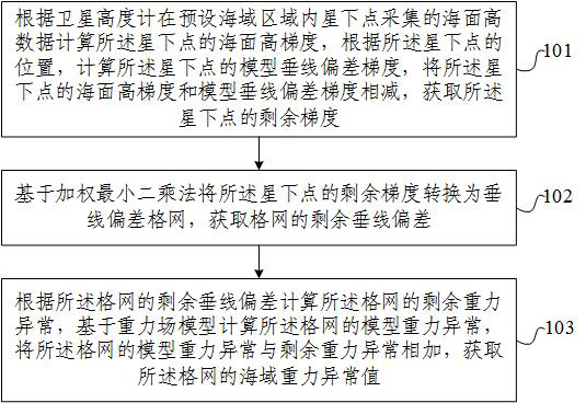
[0054] Combine below figure 1 Describe the sea area gravity anomaly inversion method based on satellite altimetry data of the present invention, comprising: Step 101, calculate the sea surface height gradient of the sub-satellite point according to the sea surface height data collected by the satellite altimeter at the sub-satellite point in the preset sea area, Calculate the model vertical ...


PUM


Abstract

The present invention provides a sea area gravity anomaly inversion method and system based on satellite altimetry data. The method includes: calculating the sea surface height gradient of the sub-satellite point according to the sea surface height data collected by the satellite altimeter at the sub-satellite point in the preset sea area, According to the position of the sub-satellite point, the model vertical deviation gradient of the sub-satellite point is calculated, and the sea surface height gradient of the sub-satellite point is subtracted from the model vertical line deviation gradient to obtain the remaining gradient of the sub-satellite point; The remaining gradient of the next point is converted into a vertical deviation grid to obtain the remaining vertical deviation of the grid; the residual gravity anomaly of the grid is calculated according to the remaining vertical deviation of the grid, and the model gravity anomaly of the grid is calculated based on the gravity field model. Add the model gravity anomaly of the grid to the remaining gravity anomaly to obtain the gravity anomaly of the sea area of ​​the grid. The present invention realizes obtaining accurate sea area gravity anomalies through rigorous theoretical derivation.

Description

technical field [0001] The invention relates to the technical field of geological surveying and mapping, in particular to a sea area gravity anomaly inversion method and system based on satellite altimetry data. Background technique [0002] The ocean is rich in oil and gas resources, which have been developed and utilized in large quantities, and have gradually become the main battlefield of human economic activities. The diverse geological structures provide important clues for human beings to study the evolution of the earth. Human economic activities and scientific research are inseparable from basic gravity data. [0003] Shipboard gravimetry is the main source of ocean gravity data. Its advantages are high measurement accuracy, low observation efficiency and small coverage in a linear grid distribution. The task of making full gravity measurements over approximately 70% of the world's surface area is extremely difficult and challenging. Before the 1970s, ocean grav...

Claims


Application Information

Patent Timeline
Patent Type & Authority Patents(China)
IPC IPC(8): G01C13/00G01V7/00
CPCG01C13/00G01V7/00
Inventor 柯宝贵张利明刘焕玲章传银党亚民高晨轩
Owner CHINESE ACAD OF SURVEYING & MAPPING
Why Eureka
Try Eureka