
Remote sensing image depth semantic segmentation method integrating regional connectivity and symbiotic knowledge constraint

A technology of regional connectivity and semantic segmentation, which is applied in the intersection of remote sensing image interpretation and artificial intelligence, can solve the problems of poor integrity of segmentation results, insufficient utilization and lack of spatial relationship and prior knowledge of geosciences, etc., to achieve automatic optimization and improvement Segmentation accuracy and segmentation results, effects of boundary blurring and suppression of random noise phenomena

Active Publication Date: 2021-05-07
WUHAN UNIV
View PDF6 Cites 3 Cited by
  • Summary
  • Abstract
  • Description
  • Claims
  • Application Information

AI Technical Summary

Problems solved by technology

[0004] The present invention mainly solves the problems of poor integrity and low accuracy of the segmentation results caused by the lack of target level learning, insufficient utilization of spatial relations and prior knowledge of geology in the process of semantic segmentation of remote sensing images in the prior art, and provides a comprehensive area The remote sensing image depth semantic segmentation method constrained by connectivity and spatial co-occurrence knowledge can effectively improve the accuracy and reliability of remote sensing image semantic segmentation results

Method used


Image

  • Remote sensing image depth semantic segmentation method integrating regional connectivity and symbiotic knowledge constraint
  • Remote sensing image depth semantic segmentation method integrating regional connectivity and symbiotic knowledge constraint
  • Remote sensing image depth semantic segmentation method integrating regional connectivity and symbiotic knowledge constraint

Examples


Embodiment Construction

[0044] In order to facilitate those of ordinary skill in the art to understand and implement the present invention, the present invention will be described in further detail below in conjunction with the accompanying drawings and embodiments. It should be understood that the implementation examples described here are only used to illustrate and explain the present invention, and are not intended to limit this invention.

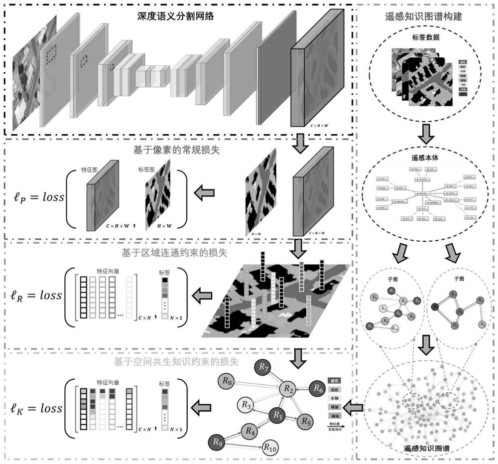
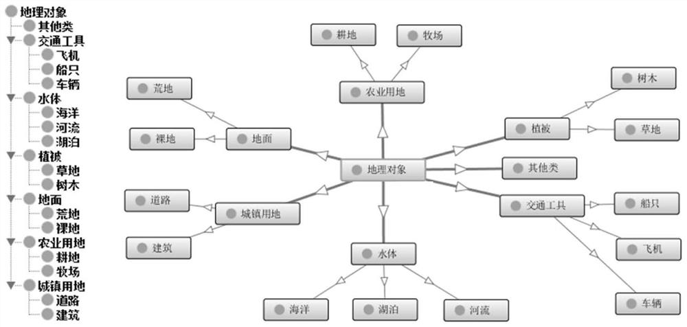
[0045] Step 1, remote sensing knowledge map construction. The remote sensing knowledge graph is used as a semantic network (the "semantic network" here refers to the network formed by the objects and the semantic relationships between them), which is used to describe the attributes of the objects and the relationship between the objects. Among them, the remote sensing ontology is the skeleton of the remote sensing knowledge graph, and the ground objects in the tag image are instantiated objects of the ontology to form the basic unit of the remote sensing know...


PUM


Abstract

The invention discloses a remote sensing image depth semantic segmentation method integrating regional connectivity and symbiotic knowledge constraints. According to the method, a target integrity constraint based on region communication and a target spatial distribution constraint based on spatial symbiotic knowledge are added into a loss function item of a deep semantic segmentation network, and the network adjusts a network model by optimizing a comprehensive loss function item added with the constraints. Therefore, target-level feature representation is autonomously learned, and spatial distribution of segmentation targets is automatically optimized by utilizing spatial symbiotic knowledge. The invention innovatively provides a remote sensing image deep semantic segmentation method integrating region connectivity constraint and spatial symbiotic knowledge constraint, and the constraint on the whole target is realized in the field of semantic segmentation for the first time; and the spatial symbiotic knowledge is quantized through the spatial symbiotic conditional probability, and the unstructured knowledge is successfully embedded into the data-driven deep semantic segmentation network, so that the segmentation precision and the segmentation result of the deep semantic segmentation network are effectively improved.

Description

technical field [0001] The invention belongs to the intersection field of remote sensing image interpretation and artificial intelligence, and relates to a deep semantic segmentation method that integrates regional connectivity and co-occurrence knowledge constraints, and specifically includes a combination of target integrity constraints based on regional connectivity and targets based on spatial co-occurrence knowledge A Deep Semantic Segmentation Method for Remote Sensing Imagery Constrained by Spatial Distribution. Background technique [0002] Vision is an important way for human beings to obtain information. It always provides people with perceptual information about the surrounding environment, including semantic information such as target outlines, positions, and spatial relationships. Thanks to the development of computer technology and machine observation technology, computer vision has become the main technical means to automatically identify the real world, endow...

Claims


Application Information

Patent Timeline
Patent Type & Authority Applications(China)
IPC IPC(8): G06T7/11G06K9/62G06T7/187G06T5/00
CPCG06T7/11G06T7/187G06T2207/10032G06F18/2411G06T5/70
Inventor 李彦胜欧阳松张永军史特
Owner WUHAN UNIV
Learn More