Multi-point geostatistics modeling parameter optimization method based on variation function

A technique of variogram and geological statistics, applied in the direction of electrical digital data processing, design optimization/simulation, special data processing applications, etc., can solve problems such as incompatibility and low efficiency of manual identification, and achieve improved optimization accuracy and model samples Multiple, high recognition accuracy

Inactive Publication Date: 2021-06-04
YANGTZE UNIVERSITY
View PDF0 Cites 4 Cited by
  • Summary
  • Abstract
  • Description
  • Claims
  • Application Information

AI Technical Summary

Problems solved by technology

The accuracy of manual recognition depends on the experience of the modeling workers, which is highly subjective. At the s

Method used


Image

  • Multi-point geostatistics modeling parameter optimization method based on variation function
  • Multi-point geostatistics modeling parameter optimization method based on variation function
  • Multi-point geostatistics modeling parameter optimization method based on variation function

Examples


Embodiment Construction

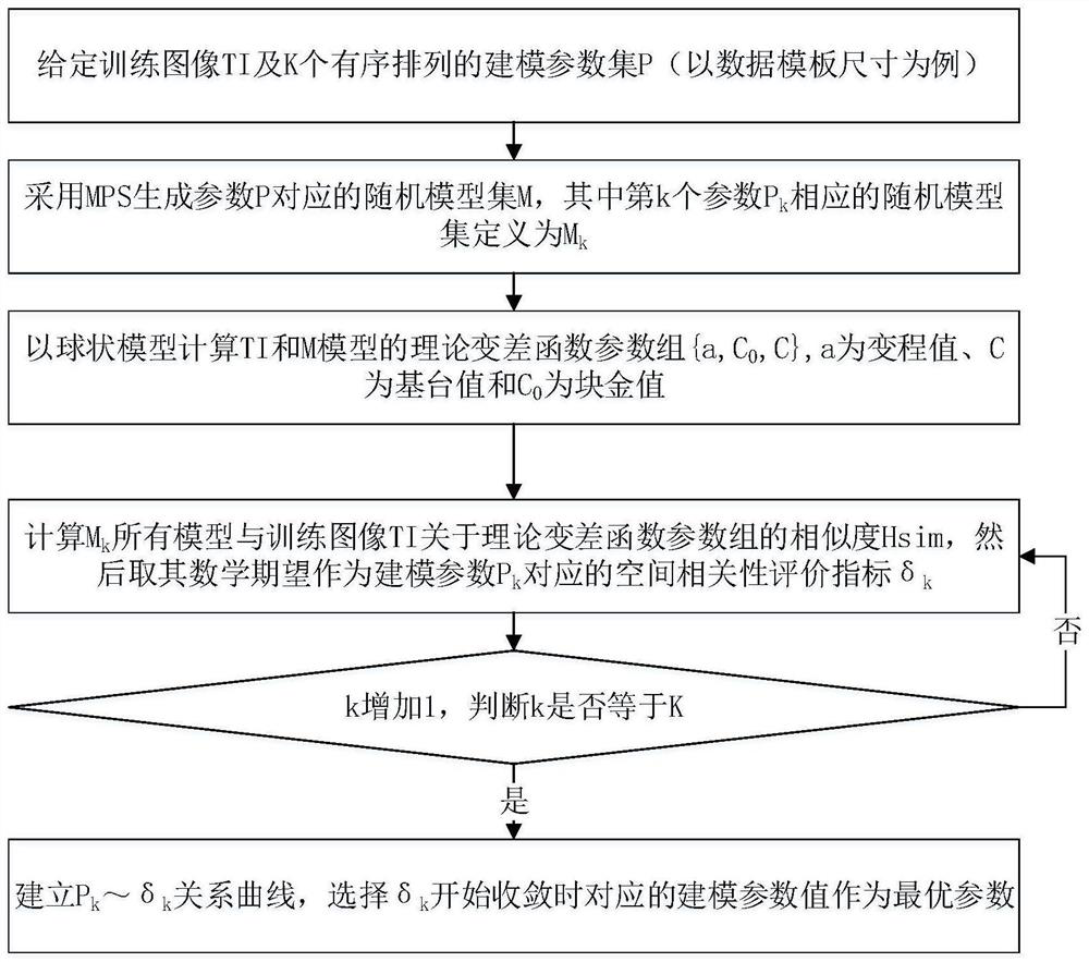
[0034] The present invention will be described in further detail below in conjunction with the accompanying drawings and specific embodiments, but these embodiments should not be construed as limiting the present invention.

[0035] In order to understand the present invention well, relevant terms are explained below:

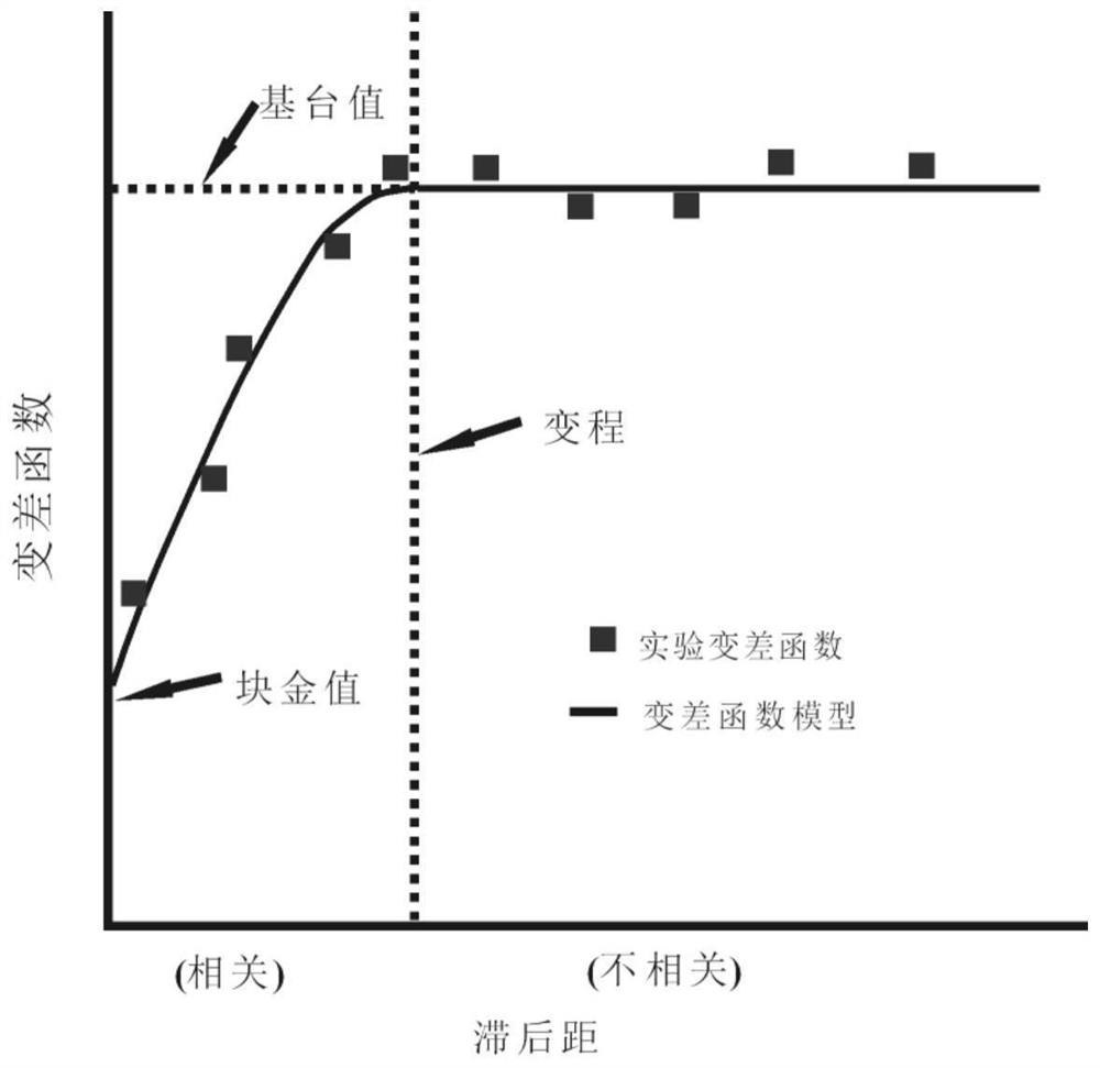
[0036] 1. Variation function (Variogram): Also known as variation function, it is a statistic describing the spatial correlation between random fields and random processes. The degree of change over a certain distance range.

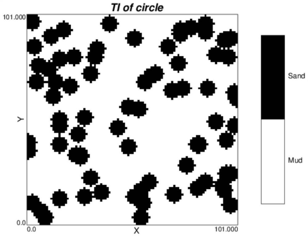
[0037] 2. Training image (TI—TrainImage): a priori geological concept model, using grid G TI As a data carrier, it is a digital model that can express the actual reservoir structure, geometry and distribution mode.

[0038] 3. Stochastic model (M——Model): the simulation realization based on the multi-point geostatistical method with the training image as the prior geological model.

[0039] 4. Multi-point geostatistics (MPS—Multiple-po...


PUM


Abstract

The invention discloses a multi-point geostatistics modeling parameter optimization method based on the variation function. The method comprises the steps of combining the correlation recognition of multi-point geostatistics model features and modeling parameters, taking the size of a data sample plate of multi-point geostatistics as an example, wherein along with the increase of the size of the sample plate, the morphological visual features of a model and a training image are more and more similar, and the modeling parameters are more and more similar; based on a variation function and an Hsim similarity function, evaluating the spatial correlation and structural feature similarity between the multipoint geostatistics random model based on the (ordered) modeling parameter set and a training image, and further establishing a relationship curve between spatial correlation evaluation indexes based on the variation function and modeling parameters; selecting a corresponding modeling parameter value when the evaluation index begins to converge and enters the platform area as an optimal parameter as a preferred parameter. Compared with a traditional artificial visual discrimination method, the method can efficiently and objectively optimize the multi-point geostatistics modeling parameters.

Description

technical field [0001] The invention relates to a multi-point geological statistical modeling parameter optimization method based on a variation function, and belongs to the technical field of reservoir geological modeling. Background technique [0002] Multi-point geostatistics is currently the mainstream method in the field of reservoir modeling. With the help of the prior geological model of the training image, it can not only meet the conditional data from different sources, but more importantly, it can well restore the existing geological understanding, including Pattern structure features such as shape and distribution relationship. However, no matter what kind of multi-point geostatistical modeling algorithm is used, the model sampling must be completed first in the process of realizing the model reconstruction, and the parameters selected by the model sampling have a direct impact on the modeling quality, so in order to improve the modeling quality must be carried ou...

Claims


Application Information

Patent Timeline
IPC IPC(8): G06F30/20G06F119/02
CPCG06F30/20G06F2119/02
Inventor 喻思羽李少华王艺博王喜鑫王军于金彪史敬华
Owner YANGTZE UNIVERSITY
Why Eureka
Try Eureka