Surveying and mapping instrument based on satellite positioning system

A technology of satellite positioning system and surveying instrument, which is applied in the field of surveying and mapping instruments, can solve the problems that the surveying and mapping instrument cannot be in a horizontal state, the influence of the accuracy of the surveying and mapping instrument, and the difficulty of fixing the surveying and mapping instrument, so as to reduce maintenance costs and construction costs, reduce maintenance costs, Improve the effect of the scope of application

Pending Publication Date: 2021-10-08
吴强
View PDF7 Cites 0 Cited by
  • Summary
  • Abstract
  • Description
  • Claims
  • Application Information

AI Technical Summary

Problems solved by technology

[0007] In order to make up for the deficiencies in the prior art, a surveying instrument based on a satellite positioning system proposed by the present invention solves the problem that it is difficult to fix the surveying instrument when the surveying instrument performs surveying and mapping on soft land, because the weight of the surveying instrument itself may cause Land subsidence will cause the surveying and mapping instrument to be unable to be in a horizontal state, which will affect the accuracy of surveying and mapping, cause construction errors, and delay the construction period. At the same time, land subsidence may cause the surveying and mapping instrument to topple. Problems that increase the maintenance and repair costs of surveying instruments
[0009] In the prior art, when the surveying instrument is used for surveying and mapping on soft land, it is not easy to fix the surveying instrument, because the weight of the surveying instrument itself may cause the land to subside, thus causing the surveying instrument to be unable to be in a horizontal state, thereby affecting the accuracy of surveying and mapping, resulting in Construction errors, delaying the construction period, and land subsidence may cause the surveying instrument to topple over. Since the surveying instrument is a precision instrument, the accuracy of the surveying instrument will be affected, thereby increasing the maintenance and repair costs of the surveying instrument;

Method used


Image

  • Surveying and mapping instrument based on satellite positioning system
  • Surveying and mapping instrument based on satellite positioning system
  • Surveying and mapping instrument based on satellite positioning system

Examples


Embodiment Construction

[0026] In order to make the technical means, creative features, goals and effects achieved by the present invention easy to understand, the present invention will be further described below in conjunction with specific embodiments.

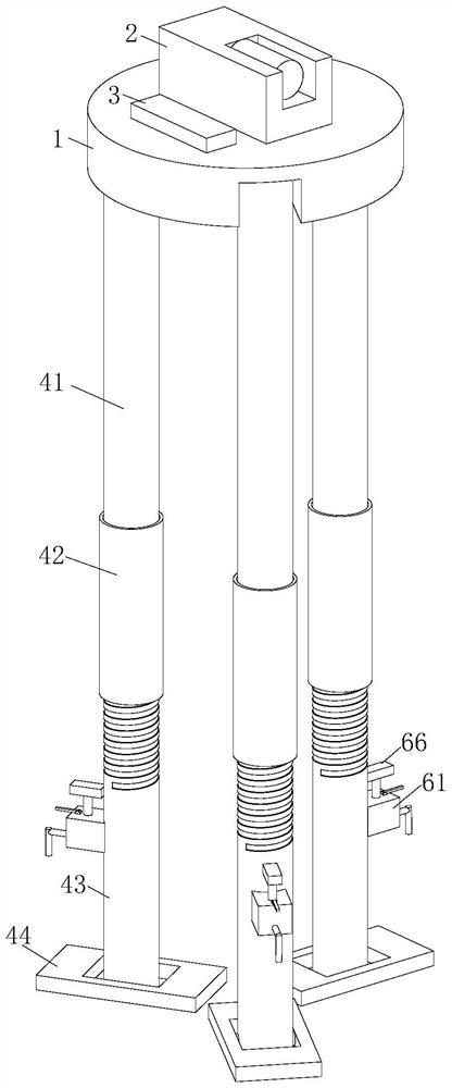
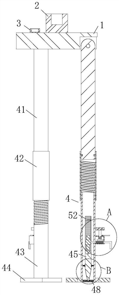
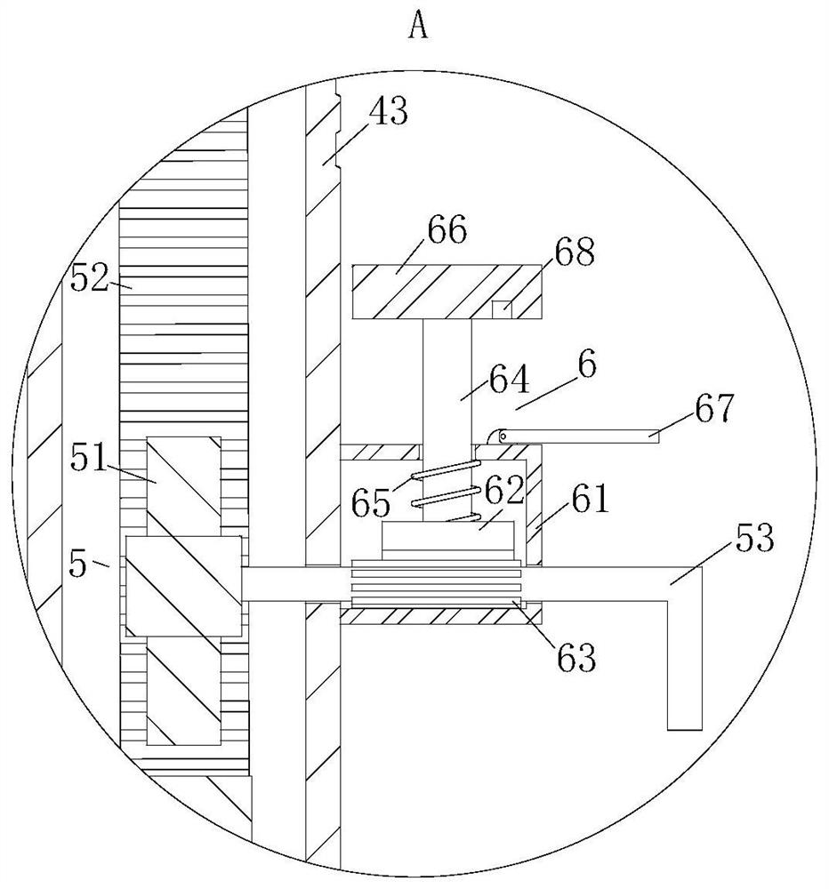
[0027] Such as Figure 1 to Figure 4As shown, a surveying instrument based on a satellite positioning system according to the present invention includes a support plate 1, a surveying instrument main body 2 is fixedly connected to the top of the support plate 1; a spirit level 3 is fixedly connected to the top of the support plate 1 The bottom of the support plate 1 is provided with a group of support modules 4, the support module 4 includes a connecting rod 41, a sleeve rod 42, a leg 43, a support block 44 and a fixed cone 45; the bottom of the support plate 1 is hinged with a connecting rod 41; the bottom end of the connecting rod 41 is rotatably connected to the sleeve rod 42; the bottom end of the sleeve rod 42 is screwed to the support leg 43...


PUM


Abstract

The invention belongs to the technical field of surveying and mapping instruments, and particularly relates to a surveying and mapping instrument based on a satellite positioning system. The surveying and mapping instrument comprises a support plate, wherein the top of the support plate is fixedly connected with a surveying and mapping instrument main body; the top of the supporting plate is fixedly connected with a gradienter. a set of supporting modules is arranged at the bottom of the supporting plate, and each supporting module comprises a connecting rod, a sleeve rod, a supporting leg, a supporting block and a fixing cone; a connecting rod is hinged to the bottom of the supporting plate; the bottom ends of the connecting rods are rotationally connected with the sleeve rods; the bottom ends of the sleeve rods are in threaded connection with the supporting legs; and the supporting blocks are hinged to the bottom ends of the supporting legs. The surveying and mapping instrument is fixed through the fixing cones, and land settlement caused by the weight of the surveying and mapping instrument is prevented, so that the surveying and mapping instrument can be kept in a horizontal working state, the surveying and mapping precision of the surveying and mapping instrument is guaranteed, and construction errors are reduced. Meanwhile, the surveying and mapping instrument can be prevented from toppling over, the precision of the surveying and mapping instrument is prevented from being damaged, and therefore, the maintenance cost of the surveying and mapping instrument is reduced.

Description

technical field [0001] The invention belongs to the technical field of surveying and mapping instruments, in particular to a surveying and mapping instrument based on a satellite positioning system. Background technique [0002] Satellite positioning system is a technology that uses satellites to accurately locate something. It has developed from the initial low positioning accuracy, incapable of real-time positioning, and difficulty in providing timely navigation services to today's high-precision GPS global positioning system. At any time and at any point on the earth, four satellites can be observed at the same time, so as to realize functions such as navigation, positioning, and timing. [0003] Simply put, surveying and mapping instruments are instruments and devices designed and manufactured for data acquisition, processing, and output for surveying and mapping operations. [0004] In the planning, design, construction and operation management stages of engineering co...

Claims


Application Information

Patent Timeline
IPC IPC(8): F16M11/04F16M11/32F16M11/36
CPCF16M11/04F16M11/32F16M11/36
Inventor 吴强胡坤曹云标
Owner 吴强
Why Eureka
Try Eureka