
Method and device for constructing high-definition satellite map vector slices based on svg format

A satellite map and map slicing technology, applied in the computer field, can solve problems such as no drawing method

Active Publication Date: 2021-10-22
成都国星宇航科技股份有限公司
View PDF13 Cites 3 Cited by
  • Summary
  • Abstract
  • Description
  • Claims
  • Application Information

AI Technical Summary

Problems solved by technology

At present, geographic information systems mainly use raster graphics technology to generate vector map slices. The mainstream format is png or jpg. At present, there are relatively few vector map slices in svg format, and there is no specific drawing method

Method used


Image

  • Method and device for constructing high-definition satellite map vector slices based on svg format
  • Method and device for constructing high-definition satellite map vector slices based on svg format
  • Method and device for constructing high-definition satellite map vector slices based on svg format

Examples


Embodiment approach

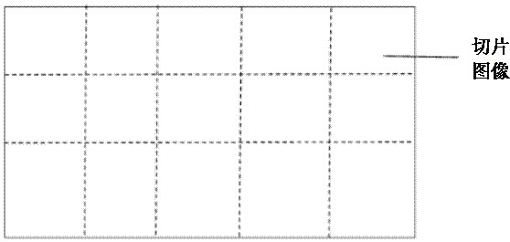
[0053]In an optional implementation manner, after each segmented image is obtained, it is also necessary to name the picture name of each sliced ​​image, so as to facilitate distinction. The process of naming the picture name of each slice image can be: according to the geographic space range of the target frame map, preset map slice rules, and preset slice levels, obtain the xyz value of each slice image, and use the obtained xyz value for each slice The picture name of the image is named. That is, for each sliced ​​image, the xyz value of the sliced ​​image is obtained according to the geographic space range of the target frame map, the preset map slice rule, and the preset slice level, and the picture name of the sliced ​​image is named according to the xyz value. Further, the target frame can be obtained according to the geographic space range (including latitude and longitude) of the target frame map, according to the preset map slicing rules (that is, the above-mentioned...


PUM


Abstract

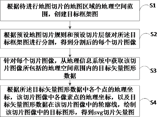
The invention relates to a method and device for constructing a high-definition satellite map vector slice based on an svg format, and belongs to the technical field of computers. The method comprises the following steps: creating a target framework diagram according to a geographic space range of a map region to be subjected to map slicing; segmenting the target frame graph according to a preset map slicing rule and a preset slicing hierarchy to obtain each segmented slice image; for each slice image, acquiring target vector graphic data in a geographic space range included in the slice image from a geographic information system; and drawing a target graph in the slice image according to the geographic coordinate of each point in the target vector graph data, the geographic coordinate of each pixel point in the slice image and the contour line of the target vector graph data in the slice image to obtain an svg slice vector graph. Compared with a traditional map slicing method, the map vector slice method provided by the invention can provide a slice file which is smaller in size, higher in transmission speed and better in display effect.

Description

technical field [0001] The present application belongs to the field of computer technology, and in particular relates to a method and device for constructing high-definition satellite map vector slices based on the svg format. Background technique [0002] With the development of the network, one of the main development directions of the geographic information system (Geographic Information System, GIS) is multivariate data access, which requires that in the distributed network, the spatial data can be opened, and can be accessed through the exchange format any data. At present, geographic information systems mainly use raster graphics technology to generate vector map slices. The mainstream format is png or jpg. Currently, there are relatively few vector map slices in svg format, and there is no specific drawing method. Contents of the invention [0003] In view of this, the purpose of this application is to provide a method and device for constructing high-definition sa...

Claims


Application Information

Patent Timeline
IPC IPC(8): G06T7/11
CPCG06T7/11G06T2207/20128
Inventor 郑博熊文轩曹彬
Owner 成都国星宇航科技股份有限公司
Learn More