Method for automatically extracting flood risk area based on SAR image

An automatic extraction, risk area technology, applied in the direction of reflection/re-radiation of radio waves, use of re-radiation, measurement devices, etc., can solve the problem of lack of automation of threshold setting, and achieve strong visualization effect, rich content, and efficient extraction. Effect

Pending Publication Date: 2021-10-29
POWERCHINA HUADONG ENG COPORATION LTD
View PDF10 Cites 4 Cited by
  • Summary
  • Abstract
  • Description
  • Claims
  • Application Information

AI Technical Summary

Problems solved by technology

Due to the complexity of the water environment, the threshold segmentation will al

Method used


Image

  • Method for automatically extracting flood risk area based on SAR image
  • Method for automatically extracting flood risk area based on SAR image
  • Method for automatically extracting flood risk area based on SAR image

Examples


Embodiment Construction

[0053] The present invention will be further described below in conjunction with the accompanying drawings and embodiments. It should be noted that the embodiments described here are only used to illustrate and explain the present invention, not to limit the present invention.

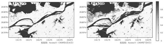
[0054] The present invention uses Sentinel-1 SAR data to extract flood risk areas. The observation time of the two-temporal images is June 26, 2020 and July 8, 2020, respectively, including the following steps:

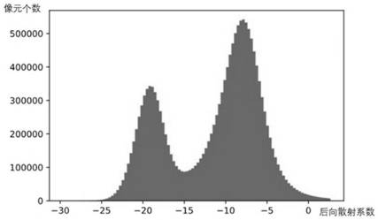
[0055] Step (1), obtain the two-temporal Sentinel-1SAR image before and after the rainfall event in the local area of ​​Poyang Lake, and perform preprocessing to obtain a 10m*10m spatial resolution image map, and combine all pixels in the study area to form backscatter Coefficient (σ 0 ) set Σ 10*10 ;

[0056] Step (2), for the set Σ 10*10 Draw a frequency histogram, assuming that there are two-temporal SAR images of water bodies σ 0 The set conforms to a mixed Gaussian distribution, and ...


PUM


Abstract

The invention discloses a method for automatically extracting a flood risk area based on an SAR image.The method comprises the steps: calculating the water body probability of two time phase SAR images before and after a flood event through employing a C wave band backscattering coefficient sigma0, and expressing a flood risk area through employing the increment of the water body probability. The method is a rapid, convenient and nearly real-time flood monitoring method, can effectively extract the newly added submerging area (flood risk area) before and after the rainfall event, and comprises the following steps: acquiring two time phase images before and after a flood event, and forming a sigma0 set; generating a frequency histogram of sigma0, assuming that sigma0 accords with Gaussian mixture distribution, and then filtering outliers; performing unsupervised classification on the downsampled sigma0 set, and calculating a prior probability; carrying out iterative calculation on the downsampled sigma0 set by utilizing an expectation maximization (EM) algorithm and the prior probability, calculating a distribution curve parameter, and calculating a water body probability based on sigma0 before downsampling; and extracting a flood risk area by using the water body probability increment of the two time phase images.

Description

technical field [0001] The invention belongs to the technical field of flood monitoring, in particular, a method for automatically extracting flood risk areas based on SAR images is invented. This method uses the C-band backscattering coefficient (σ 0 ) to calculate the water body probability of the two-temporal SAR image before and after the flood event, and then use the water body probability increment of the two-temporal image to express the newly added flood submerged area (flood risk area) after the rainfall event. This method is a simple, fast and effective flood monitoring method, which can quickly monitor the change of water body area and automatically extract flood risk areas. Background technique [0002] Global warming, frequent occurrence of abnormal climate phenomena, and increasingly frequent flood disasters have had a huge impact on human life, health, and living environment. Especially in the southern part of my country, which is mostly in the tropical and ...

Claims


Application Information

Patent Timeline
IPC IPC(8): G01S13/90
CPCG01S13/9021Y02A10/40
Inventor 白珏莹邬雪松郭靖富强张善亮房新力刘强
Owner POWERCHINA HUADONG ENG COPORATION LTD
Why Eureka
Try Eureka