Unmanned aerial vehicle railway slope monitoring and early warning system and method

A technology for unmanned aerial vehicles and slopes, which is used in radio wave measurement systems, satellite radio beacon positioning systems, alarms, etc. improved effect

Active Publication Date: 2021-11-05
BEIJING TIEKE SPECIAL ENG TECH CO LTD +4
View PDF9 Cites 11 Cited by
  • Summary
  • Abstract
  • Description
  • Claims
  • Application Information

AI Technical Summary

Problems solved by technology

[0014] The disadvantage of close-range photogrammetry technology is that the technical requirements for office processing are relatively high; the data quality requirements are high. If the data quality is poor, the matching points will be relatively sparse, and the accuracy is difficult to meet the requirements.
[0016] InSAR technology also has certain deficiencies in slope monitoring. Spaceborne InSAR technology generally has a long return cycle and low spatial resolution; in densely vegetated monitoring areas, the coherence is poor; mountainous terrain is undulating, and some elevation changes It will cause a jump throughout the week; the water vapor content is different at different altitudes in mountainous areas, which will have a greater impact

Method used


Image

  • Unmanned aerial vehicle railway slope monitoring and early warning system and method
  • Unmanned aerial vehicle railway slope monitoring and early warning system and method
  • Unmanned aerial vehicle railway slope monitoring and early warning system and method

Examples


Embodiment Construction

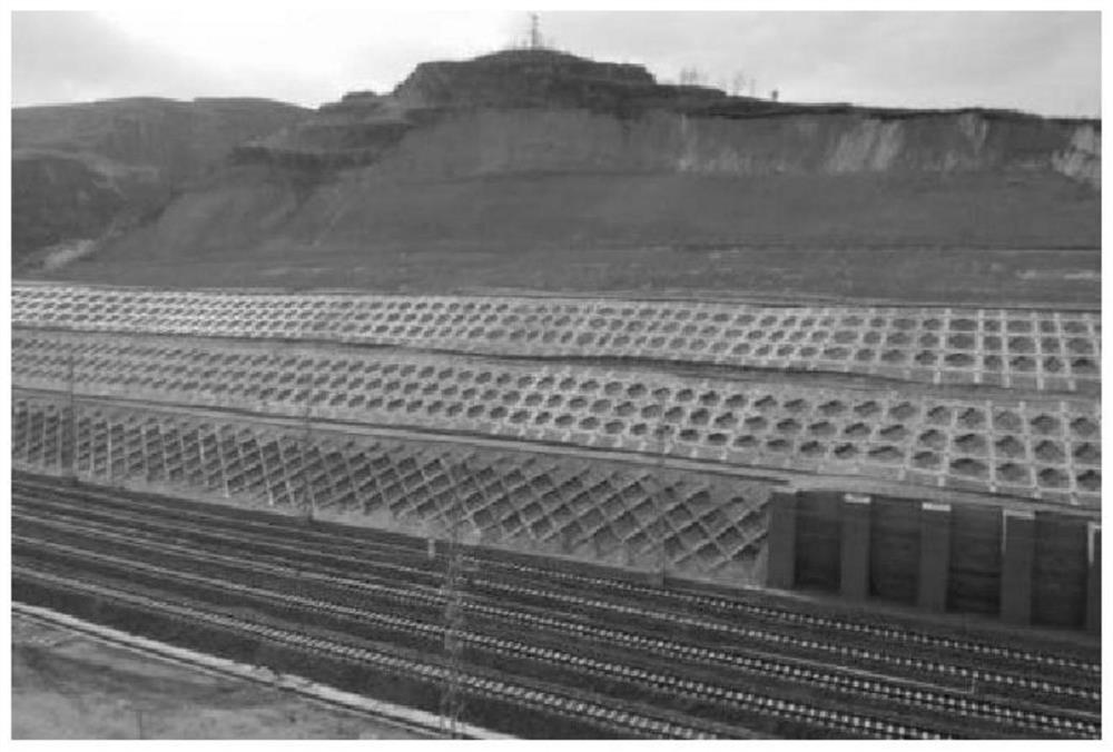
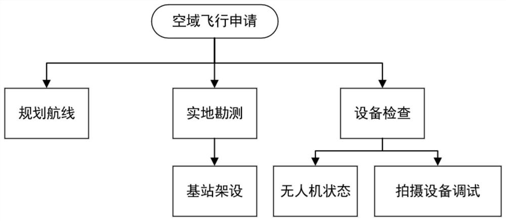
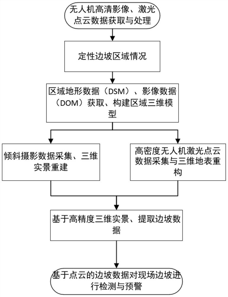
[0062] The present invention will be further described below in conjunction with the accompanying drawings. The following examples are only used to illustrate the technical solution of the present invention more clearly, but not to limit the protection scope of the present invention. It should be pointed out that the following detailed description is exemplary and is intended to provide further explanation to the present application.

[0063] Unless defined otherwise, all technical and scientific terms used herein have the same meaning as commonly understood by one of ordinary skill in the art to which this application belongs. It should be noted that the terminology used here is only for describing specific implementations, and is not intended to limit the exemplary implementations according to the present application. As used herein, unless the context clearly dictates otherwise, the singular is intended to include the plural, and it should also be understood that when the ...


PUM


Abstract

The invention relates to an unmanned aerial vehicle railway slope monitoring and early warning system and method. The method comprises the following steps: acquiring and processing unmanned aerial vehicle high-definition images and laser point cloud data; determining the condition of a slope area; obtaining regional topographic data (DSM) and regional image data (DOM), and constructing a regional three-dimensional model; carrying out oblique photography data acquisition and three-dimensional surface real scene reconstruction, and high-density unmanned aerial vehicle laser point cloud data acquisition and three-dimensional surface real scene reconstruction; based on the high-precision three-dimensional earth surface real scene, extracting slope data; and carrying out on-site slope detection and early warning based on the slope data of the point cloud. Through the combination of the unmanned aerial vehicle and the laser radar equipment, the monitoring precision is improved, the measurement automation and non-contact measurement are realized, the cost is reduced, and the labor investment is reduced.

Description

technical field [0001] The invention relates to the technical field of slope monitoring and early warning, in particular to an unmanned aerial vehicle slope monitoring and early warning system and method. Background technique [0002] Our country is in the stage of high-speed development of modernization. For large-scale engineering construction, such as highways, railways, hydropower and water conservancy facilities, mines, etc., there will be many slope projects during their construction and operation stages. Once these slopes Dangerous slopes will pose a huge threat to the safety of people's lives and property, and will also have a serious impact on the country's economic construction, restricting the rapid development of the national economy. However, the geology and topography of our country are complex. When these slopes are affected by external factors such as rainfall, construction, and earthquakes, they will develop into landslide disasters in severe cases. [0003...

Claims


Application Information

Patent Timeline
Patent Type & Authority Applications(China)
IPC IPC(8): G08B21/10G06T17/00G01S19/14
CPCG08B21/10G06T17/00G01S19/14Y02A10/23
Inventor 蔡德钩魏少伟许贵阳申文军刘英姚建平丁国富付卫霖石越峰刘瑞曹渊东安再展耿琳吕宋毕宗琦甘伟亮李金洋邹文武李博闻
Owner BEIJING TIEKE SPECIAL ENG TECH CO LTD
Why Eureka
Try Eureka