Time sequence remote sensing image crop classification method combining TWDTW algorithm and fuzzy set

A technology of remote sensing images and classification methods, applied in the field of agricultural remote sensing, can solve problems such as deformity matching, and achieve the effect of refined classification

Active Publication Date: 2021-11-12
FUZHOU UNIV
View PDF6 Cites 4 Cited by
  • Summary
  • Abstract
  • Description
  • Claims
  • Application Information

AI Technical Summary

Problems solved by technology

Dynamic time warping (Dynamic Time Warping, DTW) algorithm is a common method for time series similarity measurement, which has high flexibility, but it is easy to cause serious malformed matching.

Method used


Image

  • Time sequence remote sensing image crop classification method combining TWDTW algorithm and fuzzy set
  • Time sequence remote sensing image crop classification method combining TWDTW algorithm and fuzzy set
  • Time sequence remote sensing image crop classification method combining TWDTW algorithm and fuzzy set

Examples


Embodiment Construction

[0044] The present invention will be further described below in conjunction with the accompanying drawings and embodiments.

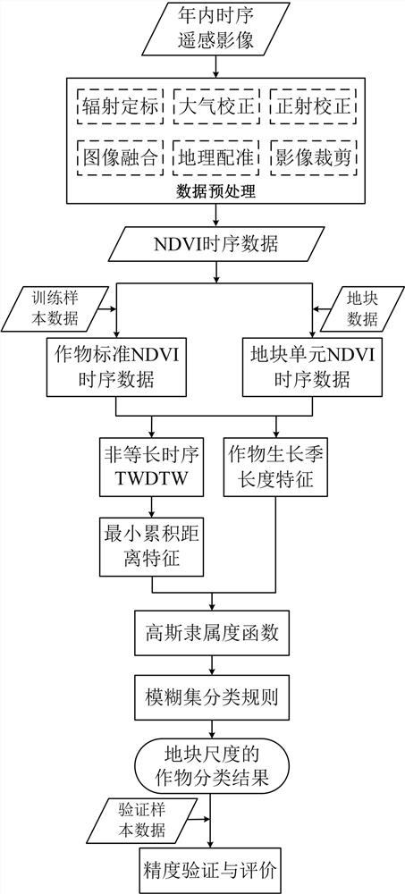
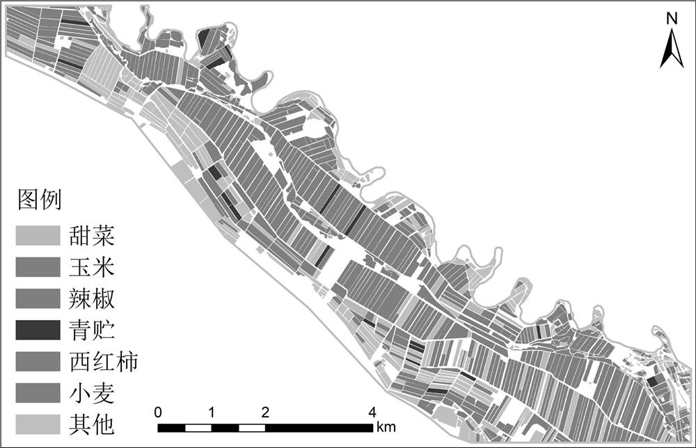
[0045] Please refer to figure 1 , the present invention provides a time-series remote sensing image crop classification method combined with TWDTW algorithm and fuzzy sets, comprising the following steps:

[0046] Step S1: Obtain time-series remote sensing image data for crop classification, plot data, and crop sample data obtained from field investigations;

[0047] Step S2: Carry out preprocessing such as radiometric calibration, atmospheric correction, orthorectification, image fusion, georeferencing, and image cropping on the remote sensing image data;

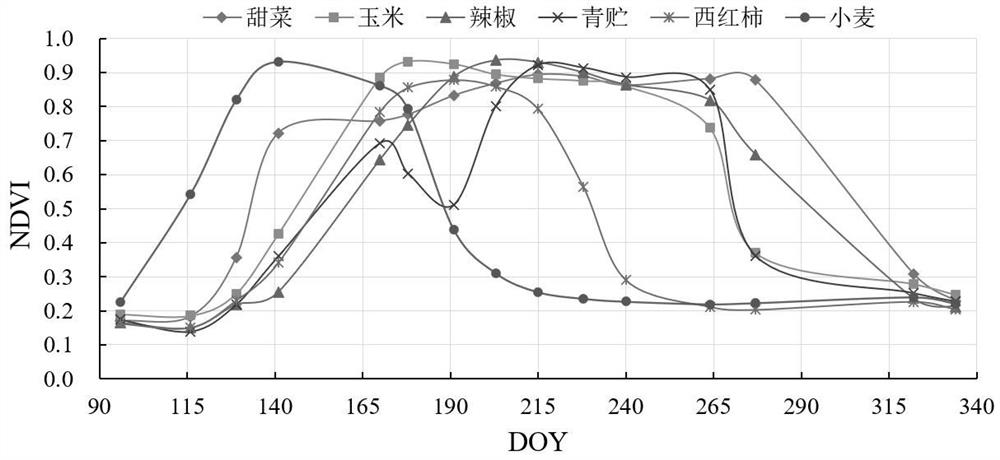
[0048] Step S3: Based on the time-series remote sensing data obtained by preprocessing in step S2, calculate the classification features of the NDVI vegetation index, and construct the NDVI time-series data set;

[0049] Step S4: Based on the time-series NDVI data set, combined with the crop sampl...


PUM


Abstract

The invention relates to a time sequence remote sensing image crop classification method combining a TWDTW algorithm and a fuzzy set. The method comprises the following steps: S1, obtaining time sequence remote sensing image data, plot data and crop sample data of a to-be-detected region; S2, preprocessing the time sequence remote sensing image data; S3, constructing an NDVI time sequence data set; S4, respectively constructing standard NDVI time sequence data of different crops and an NDVI time sequence data set of the plot units; S5, constructing a TWDTW algorithm of a non-equal-length time sequence, and obtaining a minimum cumulative distance feature matched with the similarities of different crops; S6, on the basis of the NDVI time sequence data set of the plot unit, phenological characteristics of different crop growth season lengths are calculated; and S7, on the basis of the minimum cumulative distance feature and the growth season length feature, constructing Gaussian membership functions of different crops, and on the basis of a fuzzy set classification rule, realizing refined crop classification on the plot scale. According to the invention, refined classification of crops on the plot scale is realized.

Description

technical field [0001] The invention relates to the field of agricultural remote sensing, in particular to a time-series remote sensing image crop classification method combined with a TWDTW algorithm and fuzzy sets. Background technique [0002] The crop planting structure describes the regional crop planting type and its spatial distribution information. It is an important basic data for crop growth monitoring and yield estimation. Timely and accurate acquisition of crop type and its temporal and spatial change information can help optimize crop planting structure adjustment and rational allocation of water and soil resources. is of great significance. Due to its advantages of wide coverage, short observation period, and strong current situation, remote sensing technology has become the main technical means to obtain crop classification and spatial distribution information. [0003] When carrying out remote sensing classification of multiple crops, there are overlaps and ...

Claims


Application Information

Patent Timeline
Patent Type & Authority Applications(China)
IPC IPC(8): G06K9/00G06K9/62
CPCG06F18/22
Inventor 李蒙蒙茶明星汪小钦陈芸芝龙江
Owner FUZHOU UNIV
Why Eureka
Try Eureka