
Efficient ground absolute target extraction and global optimization method

A global optimization, absolute coordinate technology, applied in the field of mobile surveying and mapping, can solve the problems of complicated operation, decreased registration accuracy, image mapping accuracy, etc., and achieves the effect of flexible and simple operation and avoiding errors.

Active Publication Date: 2021-11-23
LEADOR SPATIAL INFORMATION TECH CORP
View PDF4 Cites 0 Cited by
  • Summary
  • Abstract
  • Description
  • Claims
  • Application Information

AI Technical Summary

Problems solved by technology

This method can obtain the point cloud in the corresponding coordinate system, but the operation is very cumbersome and the accuracy is not high
[0005] 2. Cumulative error problem
[0006] The 3D-SLAM algorithm used in backpack mapping uses point cloud registration and inertial navigation to solve in the absence of satellite signals. This is a Markov process, and the pose estimation of each frame is based on the position of the previous frame. The relative increment of the attitude, although the best estimate is obtained, there is still a small error
In this way, the accuracy can be guaranteed in a short period of time, but the error will gradually accumulate over time, which will have a great impact on the accuracy of the mapping when absolute coordinate constraints are not introduced.
[0007] 3. Special scene problems
[0008] The point cloud registration in the 3D-SLAM algorithm is based on the geometric features of the scene. It has a good effect in scenes with rich geometric features, but in scenes lacking features such as corridors and tunnels, the registration accuracy will decrease and degradation will occur. , will also image the mapping accuracy
[0009] 4. Image recognition problem
Using the method based on image recognition, it is inconvenient to operate when the lens is aligned with the target, it is time-consuming and inefficient; when identifying the target, there will be recognition errors, scale errors, etc., which will affect the accuracy of the map

Method used


Image

  • Efficient ground absolute target extraction and global optimization method
  • Efficient ground absolute target extraction and global optimization method
  • Efficient ground absolute target extraction and global optimization method

Examples


Embodiment Construction

[0051] The technical solutions of the present invention will be further described below in conjunction with the accompanying drawings and embodiments.

[0052] This embodiment provides an efficient ground absolute target extraction and global optimization method, and its specific working process includes six stages, specifically:

[0053] 1) Layout control points

[0054] First, plan a suitable route according to the environment to be collected; then, on the collection route, arrange control point targets, which can be placed on the ground, walls, etc. place.

[0055] 2) Measuring control point coordinates

[0056] Use measuring equipment such as a total station to measure the absolute coordinates of all targets and record the numbers of the targets.

[0057] 3) Start data collection

[0058] Start the data collection function of the backpack and travel along the pre-planned route.

[0059] 4) Collect target

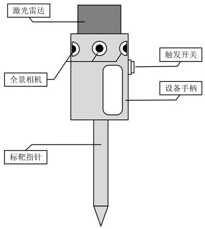
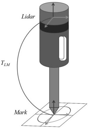
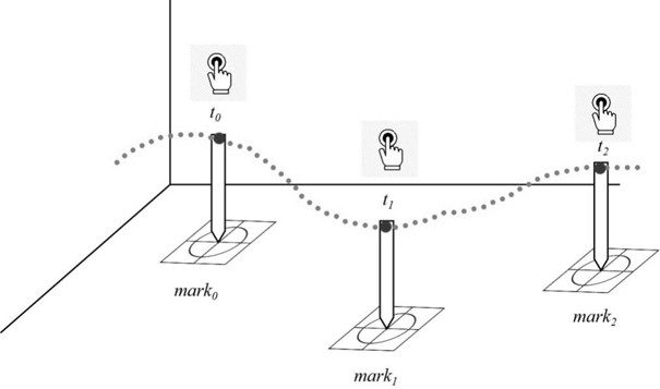
[0060] Every time you walk to a target position, touch the ce...


PUM


Abstract

The invention discloses an efficient ground absolute target extraction and global optimization method. Aiming at the problems existing in the prior art, the invention provides an efficient ground absolute target extraction method and a global optimization algorithm comprising four residual equations including absolute coordinate constraint and the like, and solves the problems that the absolute coordinate conversion precision is not high, the SLAM algorithm without absolute coordinate constraint has accumulated errors, special scene algorithm degradation is caused; and target image extraction operation is tedious and has many errors.

Description

technical field [0001] The invention belongs to the field of mobile surveying and mapping, and in particular relates to a method for acquiring target coordinates and a global trajectory optimization calculation method combined with absolute coordinate constraints. Background technique [0002] The portable mobile surveying backpack is a new type of mobile surveying and mapping technology, which can realize mobile surveying, map collection and other functions like the mobile surveying and mapping vehicle. The backpack is usually equipped with laser radar, inertial navigation and other devices. It adopts a backpack method for data collection, and then performs data processing through 3D-SLAM algorithm, and finally generates 3D point cloud. The portable mobile surveying backpack is especially suitable for parks, indoors, buildings, underground and other environments, and is a supplement for mobile surveying and mapping vehicles in surveying and mapping scenarios. In the proces...

Claims


Application Information

Patent Timeline
Patent Type & Authority Applications(China)
IPC IPC(8): G01C15/00G06T11/20
CPCG01C15/00G06T11/206
Inventor 郭晟杨京舒振张文俊
Owner LEADOR SPATIAL INFORMATION TECH CORP
Learn More