
A vehicle-road cooperative auxiliary positioning system and method based on an edge computing gateway

An auxiliary positioning system and edge computing technology, which is applied in the directions of location information-based services, specific environment-based services, vehicle components, etc., to achieve the effect of good vehicle-road collaborative management

Active Publication Date: 2022-04-22
SHENZHEN URBAN TRANSPORT PLANNING CENT +1
View PDF8 Cites 0 Cited by
  • Summary
  • Abstract
  • Description
  • Claims
  • Application Information

AI Technical Summary

Problems solved by technology

[0004] The problem solved by the invention is: how to realize the precise positioning of the mobile vehicle on the road where the satellite signal cannot be covered or the GPS signal is poor

Method used


Image

  • A vehicle-road cooperative auxiliary positioning system and method based on an edge computing gateway
  • A vehicle-road cooperative auxiliary positioning system and method based on an edge computing gateway
  • A vehicle-road cooperative auxiliary positioning system and method based on an edge computing gateway

Examples


Embodiment Construction

[0043] In order to make the above objects, features and advantages of the present invention more comprehensible, specific embodiments of the present invention will be described in detail below in conjunction with the accompanying drawings.

[0044] It should be noted that the terms "first" and "second" in the description and claims of the present invention and the above drawings are used to distinguish similar objects, but not necessarily used to describe a specific sequence or sequence. It is to be understood that the data so used are interchangeable under appropriate circumstances such that the embodiments of the invention described herein can be practiced in sequences other than those illustrated or described herein.

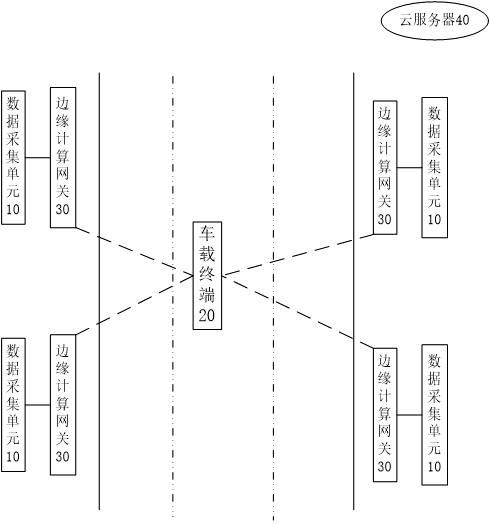
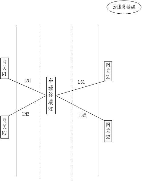
[0045]Due to the lack of full coverage of satellite signals, there are local road sections (such as high-rise road sections, remote mountainous road sections, tunnels, etc.) on the road where the vehicle is driving without satellite signals or poor GPS signals...


PUM


Abstract

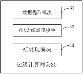
The present invention provides a vehicle-road cooperative auxiliary positioning system and method based on an edge computing gateway. The positioning system includes a vehicle-mounted terminal, an edge computing gateway, a data collection unit, and a cloud server; the data collection unit is used to collect road information of roads; The edge computing gateway is used to send the road information to the cloud server; the cloud server is used to generate the road model according to the road information, and send the road model to each edge computing gateway; the edge computing gateway is also used to calibrate the detection interval when the vehicle is driving on the road , the position information of the calibration vehicle is determined according to the signal strength value of the V2X communication between each edge computing gateway and the vehicle terminal in the detection interval and the gateway coordinates of each edge computing gateway in the detection interval. In this way, even if the vehicle is driving on a road with no satellite signal or poor GPS signal, it can still accurately locate unknown vehicles on the road.

Description

technical field [0001] The invention relates to the technical field of intelligent networked vehicles, in particular to a vehicle-road cooperative auxiliary positioning system and method based on an edge computing gateway. Background technique [0002] At present, vehicle-road coordination has become an important part of smart transportation and smart cities, and has become the future development direction of smart roads. Among them, high-precision vehicle positioning is a necessary condition for realizing smart transportation and automatic driving. [0003] In the prior art, the vehicle wireless communication technology (ie V2X) is usually used to carry the global satellite positioning system (ie GNSS) for high-precision vehicle positioning. This positioning system is a high-precision GNSS enhanced positioning technology based on real-time dynamic measurement (ie RTK), that is, this positioning system needs to continuously receive satellite data and continuously optimize er...

Claims


Application Information

Patent Timeline
Patent Type & Authority Patents(China)
IPC IPC(8): H04W64/00H04W4/40H04W4/029
CPCH04W64/006H04W4/40H04W4/029
Inventor 丘建栋李琅庄立坚黄琳惠李文彬黄丽萍修科鼎
Owner SHENZHEN URBAN TRANSPORT PLANNING CENT
Learn More