Low-altitude autonomous navigation system for rotary-wing unmanned plane

An autonomous navigation system and unmanned rotor technology, which is applied in the field of algorithm control of rotor UAVs, can solve the problems of huge weather influence, high cost, and inability to take off and land vertically, and achieve clear and accurate spatial data and attitude calculation accuracy High, reduce the effect of manpower and material resources

Inactive Publication Date: 2015-11-25
NORTHEAST AGRICULTURAL UNIVERSITY
View PDF5 Cites 53 Cited by
  • Summary
  • Abstract
  • Description
  • Claims
  • Application Information

AI Technical Summary

Problems solved by technology

But these traditional measurement methods are not applicable in some cases, and will greatly increase the cost, which brings many problems:
[0005] 1. The traditional measurement method is greatly affected by the regional weather, which greatly interferes with the collected data. For example, in the cloudy and foggy weather in the Sichuan Basin, at this time, the aerospace measurement using satellites and large aircraft as a platform is often blocked by clouds, making it difficult to take pictures. High-resolution images with satisfactory overlap
[0006] 2. In terms of agriculture and forestry, due to the complex crop planting situation in our country, the variety of crop varieties, and the small scale of farmers, in the case of realizing precision agriculture in a small range, the traditional measurement methods cannot meet the requirements, and the cost is high, and the farmland information is low. Acquisition system has better development prospects
[0007] 3. Aerial photography of large fixed-wing aircraft requires gliding and running, which has strict requirements on the site, cannot take off and land vertically, and cannot be applied if the site requirements cannot be met.

Method used


Image

  • Low-altitude autonomous navigation system for rotary-wing unmanned plane
  • Low-altitude autonomous navigation system for rotary-wing unmanned plane
  • Low-altitude autonomous navigation system for rotary-wing unmanned plane

Examples


Embodiment Construction

[0030] The present invention will be further described in detail below in conjunction with the accompanying drawings and embodiments.

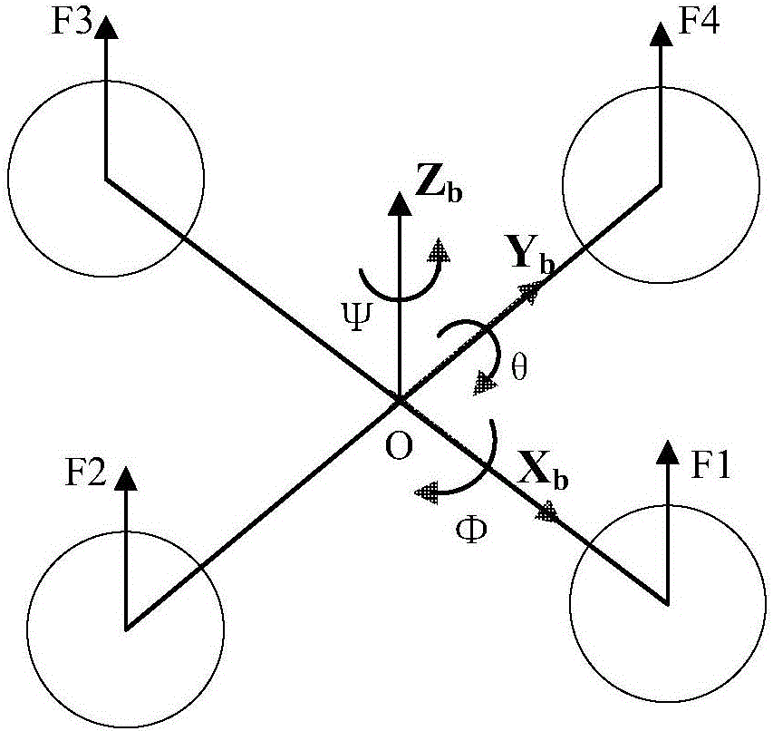
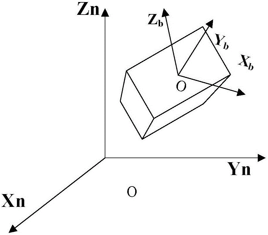
[0031] Figure 1a , Figure 1b Shown is a schematic diagram of the body coordinate system and geographic coordinate system of the quadrotor UAV. The origin O of the body coordinate system b is taken at the center of mass of the aircraft, and X b In the plane of the aircraft pointing to the front motor of the frame, Y b Pointing to the left motor in the aircraft plane, Z b perpendicular to X b OY b The plane goes straight up. The origin O of the ground coordinate system g is a point on the ground, Xg points to the North Pole, Xg points to the east in the horizontal direction, and Zg is vertical to the horizontal plane.

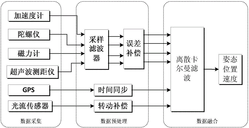
[0032] Such as figure 2 Shown is a schematic diagram of the structure of the data acquisition device, data preprocessing module, and data fusion module in the low-altitude autonomous navigation system of the rotor UAV. ...


PUM


Abstract

The invention discloses a low-altitude autonomous navigation system for a rotary-wing unmanned plane. The low-altitude autonomous navigation system is composed of a data acquisition device, a data preprocessing module, a data fusion module, a guidance control loop module and an attitude control loop module. The data preprocessing module is used for carrying out sampling filtering and error compensation on current location data information collected by the data acquisition device; the data fusion module is used for carrying out fusion and updating and obtaining a current position and speed of the rotary-wing unmanned plane; the guidance control loop module is used for calculating an expected attitude angle and an expected height value; and the attitude control loop module is used for generating a controlled quantity. According to the technical scheme, a problem of poor attitude estimation precision of the conventional navigation system can be solved; and requirements of high-precision heading attitude calculation and position and speed fusion of the rotary-wing unmanned plane can be met. High-precision filtering of the system is realized. On the basis of the analysis and calculation of the autonomous navigation system, the flight route and height can be corrected and the flight attitude can be adjusted autonomously; and the autonomous flight of the unmanned plane can be realized.

Description

technical field [0001] The invention relates to an algorithm control technology of a rotor drone, in particular to a control technology for keeping the rotor drone at a low altitude for automatic flight. Background technique [0002] With the rapid development of modern information technology, microelectronics technology and new material technology, the demand for spatial data is rapidly expanding. A large amount of real-time spatial data. How to quickly obtain these spatial data has become a hot research issue today. [0003] The application of rotorcraft in agriculture and forestry is mainly based on its low cost, small size, vertical takeoff and landing, and autonomous navigation. When collecting spatial data in agriculture and forestry, the rotor UAV can navigate autonomously, and has high flight stability. It can hover at a fixed point to collect spatial data, and can obtain clear and accurate agricultural and forestry information more advantageously. It is used as an...

Claims


Application Information

Patent Timeline
Patent Type & Authority Applications(China)
IPC IPC(8): G05D1/08G05D1/10B64D31/06
Inventor 王树文李明王润涛张长利张伶鳦刘超吕涛
Owner NORTHEAST AGRICULTURAL UNIVERSITY
Why Eureka
Try Eureka