
A large-area high-fidelity satellite remote sensing image uniform color mosaic processing method and device

A satellite remote sensing image and processing method technology, applied in the field of surveying and mapping science, can solve problems such as large color differences, lack of fixed solutions and processes, satellite data source color uniformity and complex mosaic work, etc., to achieve good results

Active Publication Date: 2022-04-08
自然资源部国土卫星遥感应用中心
View PDF19 Cites 0 Cited by
  • Summary
  • Abstract
  • Description
  • Claims
  • Application Information

AI Technical Summary

Problems solved by technology

[0004] In view of this, the present invention provides a large-area high-fidelity satellite remote sensing image uniform color mosaic processing method, which solves the color difference between images imaged at different times in the same area due to different satellite image imaging conditions, time and atmospheric environment in the prior art The large size, coupled with the differences between different sensors, makes the color uniformity and mosaic work of multiple satellite data sources very complicated, and there is a lack of effective fixed solutions and technical problems of the process

Method used


Image

  • A large-area high-fidelity satellite remote sensing image uniform color mosaic processing method and device
  • A large-area high-fidelity satellite remote sensing image uniform color mosaic processing method and device
  • A large-area high-fidelity satellite remote sensing image uniform color mosaic processing method and device

Examples


Embodiment 1

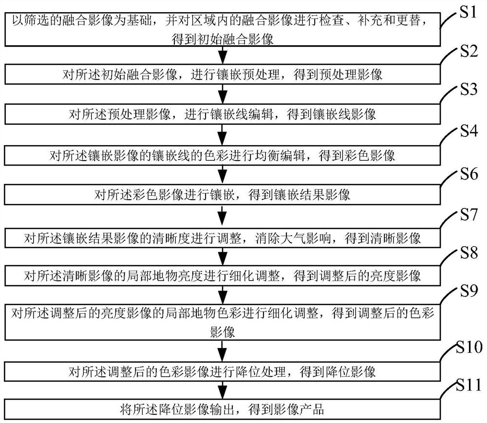
[0095] figure 1 A schematic flowchart of a method for leveling and mosaicking a large-area high-fidelity satellite remote sensing image provided by an embodiment of the present invention; such as figure 1 As shown, a large-area high-fidelity satellite remote sensing image color leveling mosaic processing method, the method includes:

[0096] S1: Based on the filtered fusion images, check, supplement and replace the fusion images in the area to obtain the initial fusion images;

[0097] S2: Perform mosaic preprocessing on the initial fusion image to obtain a preprocessed image;

[0098] S3: Perform mosaic line editing on the preprocessed image to obtain a mosaic line image;

[0099] S4: performing balanced editing on the colors of the mosaic lines of the mosaic line image to obtain a color image;

[0100] S6: Mosaic the color image to obtain a mosaic result image;

[0101] S7: Adjust the definition of the mosaic result image to eliminate atmospheric influence and obtain a c...

Embodiment 2

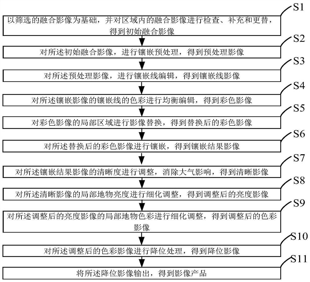
[0144] According to the method of Example 1, in some embodiments, as figure 2 As shown, on the basis of the method in Embodiment 1, between steps S4 and S6, step S5 is selectively added, specifically:

[0145] S5: Perform image replacement on a local area of ​​the color image;

[0146] S51 : Modify and / or replace the local area of ​​the color image after color equalization to achieve an overall mosaic effect.

[0147] The step S5 has practical operability for data selection and replacement of multiple overlapping images in an area. For images with two overlapping areas, you only need to edit mosaic lines in the overlapping areas, but for images with multiple overlapping areas, the selection and editing of mosaic lines will be very complicated. Therefore, the method is based on the above-mentioned single scene results and mosaic results after color equalization, and on this basis, the local area is modified and edited to achieve the overall mosaic effect.

Embodiment 3

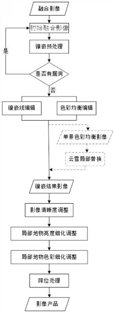
[0149] The present embodiment provides a large-area high-fidelity satellite remote sensing image color leveling mosaic processing method based on specific embodiments and actual operations, such as image 3 shown, as follows:

[0150] S1: Based on the filtered fusion images, check, supplement and replace the fusion images in the area to obtain the initial fusion images:

[0151] Image Screening: Screen images starting from the single-view panchromatic and multispectral orthorectified true-color fusion images. Check the overall data coverage and image quality of the operation area, understand the types of regional features, and determine the areas that need to be supplemented and replaced to complete the image replacement. Four aspects need to be considered in this step: the effective data coverage ratio of the operation area, the size of the vulnerability area; the coverage ratio of the cloud and snow area; the size of the seasonal difference between adjacent images; the size...


PUM


Abstract

The invention provides a large-area high-fidelity satellite remote sensing image uniform color mosaic processing method and device, comprising the following steps of screening fusion images, and checking, supplementing and replacing the fusion images; performing mosaic preprocessing on the initial fusion images, Perform mosaic line editing on the preprocessed image, perform balanced editing of the color of the mosaic line, and perform mosaic, adjust the clarity of the image, eliminate the influence of the atmosphere, and fine-tune the brightness and color of the local features of the image, The image is degraded, and the image product is output. The method of the present invention solves the problem that in the prior art, due to the difference in satellite image imaging conditions, time and atmospheric environment, the color difference between the images imaged at different times in the same area is relatively large, and the difference between different sensors makes a variety of satellite data sources The color uniformity and mosaic work has become very complicated, and there is a lack of effective fixed solutions and technical problems of the process.

Description

technical field [0001] The invention relates to the field of surveying and mapping science and technology, and in particular relates to a method and a device for color-leveling and mosaicking processing of large-area high-fidelity satellite remote sensing images. Background technique [0002] Due to the different imaging conditions, time and atmospheric environment of satellite imagery, the color difference between images imaged at different times in the same area is large, and the difference between different sensors makes the color leveling and mosaic work of various satellite data sources very difficult. Complex, lacking proven fixed solutions and processes. [0003] From the perspective of satellite image imaging characteristics, the main problems affecting the color leveling and mosaic processing of satellite images are: differences in satellite sensors, differences in radiation resolution of satellite images, differences in satellite imaging in different phases, cloud ...

Claims


Application Information

Patent Timeline
Patent Type & Authority Patents(China)
IPC IPC(8): G06T5/00G06T7/62
CPCG06T5/008G06T7/62G06T2207/20221G06T2207/10024G06T2207/10032
Inventor 李鸿洲刘书含薛白何昭宁王艺颖王霞郭莉
Owner 自然资源部国土卫星遥感应用中心
Features
  • Generate Ideas
  • Intellectual Property
  • Life Sciences
  • Materials
  • Tech Scout
  • Unparalleled Data Quality
  • Higher Quality Content
  • 60% Fewer Hallucinations
Learn More