Landslide recognition knowledge base establishment method and device, electronic equipment and storage medium

A technology for establishing a method and a knowledge base, which is applied in the field of establishing a landslide identification knowledge base, electronic equipment and storage media, and devices, and can solve problems such as the increase of the landslide volume, the false landslide, and the accurate determination of the boundary of the landslide that cannot be used, so as to improve the accuracy , the effect of improving data accuracy

Pending Publication Date: 2022-01-28
AEROSPACE INFORMATION RES INST CAS +1
View PDF0 Cites 5 Cited by
  • Summary
  • Abstract
  • Description
  • Claims
  • Application Information

AI Technical Summary

Benefits of technology

This technology helps identify landslides more accurately through images from an area where they are located on top or underground. It uses this data to improve understanding about them better than previous methods based only on their appearance alone.

Problems solved by technology

This patents describes how ground slide accidents are caused through human factors such as accident investigations, concealed dangers assessments, and monitoring systems that use satellites. Current methods have limitations including high costs associated with analyzers themselves, limited range resolution, poor depth perception capabilities, difficulty recognizing small changes near landforms, and lacked automated means for accurate analysis of these issues. Therefore, current methodologies require expensive equipment like digital cameras or sophistically trained experts to achieve their goals.

Method used


Image

  • Landslide recognition knowledge base establishment method and device, electronic equipment and storage medium
  • Landslide recognition knowledge base establishment method and device, electronic equipment and storage medium
  • Landslide recognition knowledge base establishment method and device, electronic equipment and storage medium

Examples


Embodiment Construction

[0041]In order to make the purpose, technical solutions and advantages of the present invention clearer, the technical solutions in the present invention will be clearly and completely described below in conjunction with the accompanying drawings in the present invention. Obviously, the described embodiments are part of the embodiments of the present invention , but not all examples. Based on the embodiments of the present invention, all other embodiments obtained by persons of ordinary skill in the art without creative efforts fall within the protection scope of the present invention.

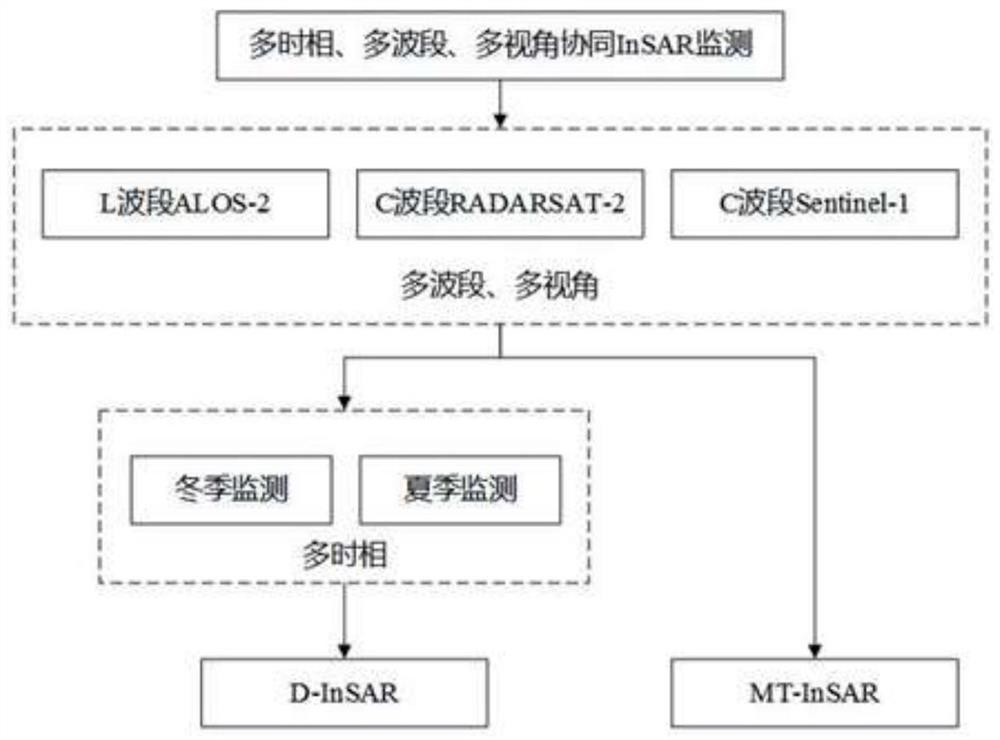
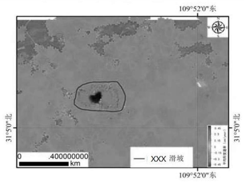
[0042] Combine below Figure 1-Figure 5 Describe the landslide identification knowledge base establishment method, device, electronic equipment and storage medium provided by the present invention.

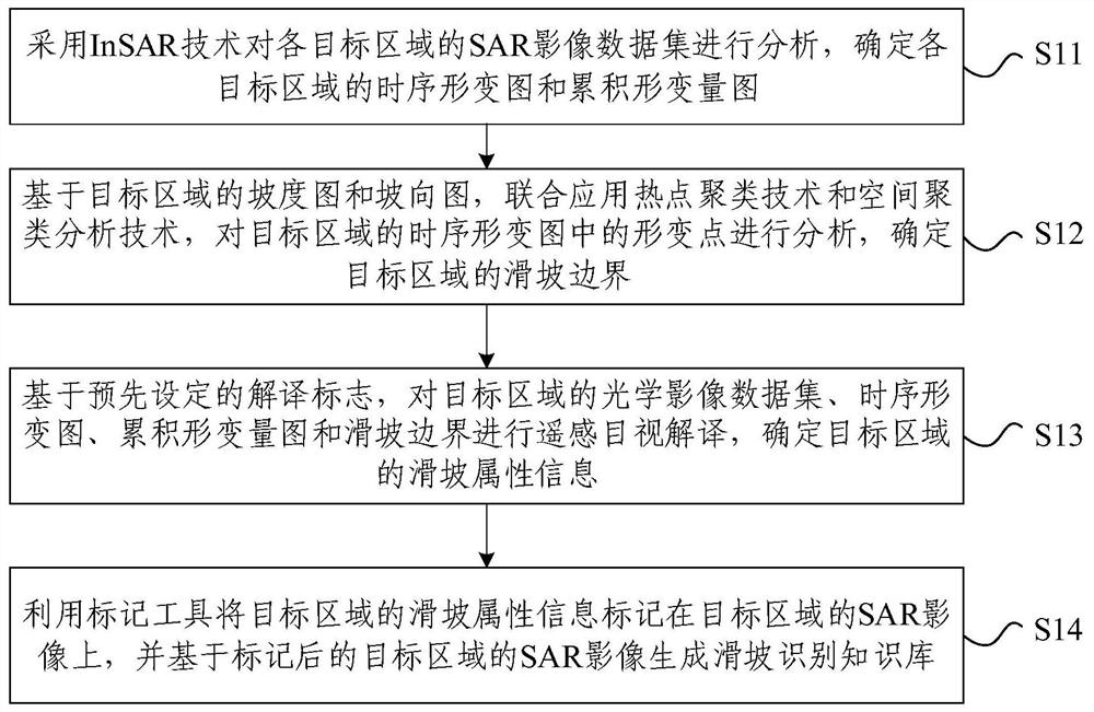
[0043] First aspect, such as figure 1 As shown, a kind of landslide identification knowledge base establishment method provided by the present invention comprises:

[0044] S11. Use InSAR techn...


PUM


Abstract

The invention relates to a landslide recognition knowledge base establishment method and device, electronic equipment and a storage medium. The method comprises the following steps: carrying out the analysis of an SAR image data set of each target region through employing an InSAR technology, and determining a time sequence deformation diagram and an accumulated deformation diagram of each target region; based on the slope map and the slope direction map of the target area, deformation points in the time sequence deformation map of the target area are analyzed by jointly applying a hotspot clustering technology and a spatial clustering analysis technology, and the landslide boundary of the target area is determined; and based on a preset interpretation mark, performing remote sensing visual interpretation on the optical image data set, the time sequence deformation diagram, the accumulated deformation quantity diagram and the landslide boundary of the target area, and determining landslide attribute information of the target area. According to the method, the influence of the slope direction and the slope on landslide recognition is considered, the accuracy of the obtained landslide attribute information is improved, the data precision of a landslide recognition knowledge base is further improved, and a good foundation is laid for subsequent AI automatic recognition.

Description


Claims


Application Information

Patent Timeline
Owner AEROSPACE INFORMATION RES INST CAS
Why Eureka
Try Eureka