A large-scale remote sensing inversion method of forest height considering ecological zoning

A technology of ecological zoning and remote sensing inversion, applied in the field of forestry remote sensing, can solve the problems of poor regional representation and low accuracy

Active Publication Date: 2022-04-15
WUHAN UNIV
View PDF3 Cites 0 Cited by
  • Summary
  • Abstract
  • Description
  • Claims
  • Application Information

AI Technical Summary

Problems solved by technology

[0004] Aiming at the problems of low accuracy and poor regional representation of current large-scale forest height estimation algorithms, the present invention provides a large-scale forest height remote sensing inversion method that takes into account ecological divisions

Method used


Image

  • A large-scale remote sensing inversion method of forest height considering ecological zoning
  • A large-scale remote sensing inversion method of forest height considering ecological zoning
  • A large-scale remote sensing inversion method of forest height considering ecological zoning

Examples


Embodiment Construction

[0025] The present invention provides a large-scale forest height remote sensing inversion method that takes into account ecological divisions. The following uses Landsat8 image data in eastern China in 2019, a random forest model constructed by Google Earth Engine, and a technical solution of the present invention in conjunction with the accompanying drawings and embodiments. for further clarification.

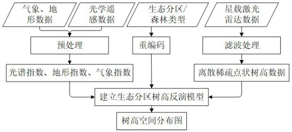
[0026] Such as figure 1 As shown, the process of the embodiment of the present invention includes the following steps:

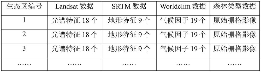
[0027] Step 1. Obtain ICESAT-2 tree height data, Landsat data, SRTM data, Worldclim data, forest type data and ecological zoning data within the target area, and preprocess the data, including the following steps:

[0028] Step 1.1, use Google Earth Engine to collect Landsat data, SRTM data, Worldclim data and forest type data in eastern China in 2019.

[0029] Step 1.2, use the data quality layer in the cloud masking method CFmask to remove the clouds an...


PUM


Abstract

The invention relates to a large-scale forest height remote sensing inversion method considering ecological division. First, combine forest ecological partition data with spaceborne photon counting lidar, optical imagery, terrain data, meteorological data, and latitude and longitude data, and then create a multi-source remote sensing data nonparametric tree height model that takes into account different ecological partitions and different forest types. Use this model to estimate spatially continuous forest heights across the study area. The present invention comprehensively considers ecological factors related to forest growth, and obtains a remote sensing-ecological coupled forest height estimation model by incorporating ecological partition factors into forest height modeling, which can generate forest heights from global and regional scales to more local scales. Spatial information to help.

Description

technical field [0001] The invention belongs to the technical field of forestry remote sensing, and in particular relates to a large-scale forest height remote sensing inversion method in consideration of ecological divisions. Background technique [0002] In the field of forestry, tree height is one of the most important tree measuring factors. The traditional method of obtaining tree height is usually to measure a single tree in the forest by using the principle of trigonometric function through an altimeter. This method mainly relies on manual acquisition of tree height information, which is difficult, cumbersome and lengthy for national-scale tree height estimation. ,Inefficient. Satellite remote sensing technology is reproducible and can realize large-area and high-efficiency forest height monitoring. However, optical satellite remote sensing images can only represent information in the horizontal direction of forests, and have no ability to detect vertical forest stru...

Claims


Application Information

Patent Timeline
Patent Type & Authority Patents(China)
IPC IPC(8): G06V20/13G06V10/764G06V10/774G06K9/62
CPCG06F18/24323G06F18/214Y02A90/10G06V20/194G06V20/188G06V20/13G06V10/58G06V10/774G06V10/764G01C11/04
Inventor 巫兆聪时芳琳
Owner WUHAN UNIV
Why Eureka
Try Eureka