A method and device for underwater long-range navigation and positioning based on pure inertial measurement

An inertial measurement, navigation and positioning technology, applied in the field of navigation systems, can solve problems such as unusability, divergence of navigation information, loss of concealment of aircraft, etc., and achieve the effect of avoiding the cumulative effect of errors

Active Publication Date: 2022-04-19
NAT INNOVATION INST OF DEFENSE TECH PLA ACAD OF MILITARY SCI
View PDF4 Cites 0 Cited by
  • Summary
  • Abstract
  • Description
  • Claims
  • Application Information

AI Technical Summary

Problems solved by technology

The second integration process will inevitably accumulate and amplify the amount of noise in the measurement data, which will eventually lead to the divergence of the calculated navigation information until it cannot be used
However, while receiving satellite signals, the current position of the aircraft is also exposed, making the aircraft lose its concealment

Method used


Image

  • A method and device for underwater long-range navigation and positioning based on pure inertial measurement
  • A method and device for underwater long-range navigation and positioning based on pure inertial measurement
  • A method and device for underwater long-range navigation and positioning based on pure inertial measurement

Examples


Embodiment Construction

[0058] The technical solutions of the present invention will be clearly and completely described below in conjunction with the accompanying drawings. Apparently, the described embodiments are part of the embodiments of the present invention, not all of them. Based on the embodiments of the present invention, all other embodiments obtained by persons of ordinary skill in the art without making creative efforts belong to the protection scope of the present invention.

[0059] In the description of the present invention, it should be noted that the terms "center", "upper", "lower", "left", "right", "vertical", "horizontal", "inner", "outer" etc. The indicated orientation or positional relationship is based on the orientation or positional relationship shown in the drawings, and is only for the convenience of describing the present invention and simplifying the description, rather than indicating or implying that the referred device or element must have a specific orientation, or i...


PUM


Abstract

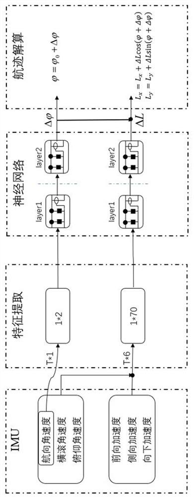
The invention discloses a method and device for underwater long-range navigation and positioning based on pure inertial measurement, wherein the method includes the following steps: S1. Inertial measurement data preprocessing, performing data preprocessing on the pure inertial measurement data of an inertial measurement unit; S2 .Motion feature extraction, extracting the hidden carrier motion features in the data, and correlating carrier navigation and positioning parameters; S3. Neural network model training, through neural network model training, to build a mapping model between inertial data features and navigation parameters. ; S4. Neural network model prediction, input the data into the mapping model between the inertial data features obtained through training and the relevant quantities of the navigation parameters to obtain the output value of the neural network, and calculate the carrier navigation parameters. The method and device can realize the estimation of the navigation parameters of the carrier from the perspective of the characteristics of the inertial data, thereby avoiding the error accumulation effect caused by the traditional navigation solution directly using the inertial measurement data.

Description

technical field [0001] The invention relates to the technical field of navigation systems, in particular to an underwater long-range navigation and positioning method and device based on pure inertial measurement. Background technique [0002] The inertial measurement unit (IMU) is an important part of the inertial navigation system (INS). The inertial navigation system relies on sensitive devices such as gyroscopes and accelerometers to record the movement of the carrier in the inertial coordinate system, and provides all-weather navigation with the help of basic Newtonian mechanics knowledge. Information independent autonomous navigation system. [0003] Because the inertial navigation system has outstanding advantages such as continuous output of carrier position, velocity and attitude information, high short-term navigation accuracy, and complete independence, it is widely used in the navigation of vehicles, ships, and aircraft. However, for the requirements of long-end...

Claims


Application Information

Patent Timeline
Patent Type & Authority Patents(China)
IPC IPC(8): G01C21/16G01C21/20G06N3/08
CPCG01C21/16G01C21/20G06N3/08
Inventor 于化鹏李子圆沈同圣赵德鑫
Owner NAT INNOVATION INST OF DEFENSE TECH PLA ACAD OF MILITARY SCI
Why Eureka
Try Eureka