Equal-depth-region-constrained nautical chart high-precision digital water depth model construction method

A construction method and technology for nautical charts, which are applied in the field of building high-precision digital bathymetry models for nautical charts, can solve problems such as deviations, and achieve the effect of improving quality and overcoming obvious deviations.

Pending Publication Date: 2022-03-04
PLA DALIAN NAVAL ACADEMY
View PDF0 Cites 0 Cited by
  • Summary
  • Abstract
  • Description
  • Claims
  • Application Information

AI Technical Summary

Problems solved by technology

[0005] In order to solve the deviation problem that the current DDM construction method is prone to occur when constructing nautical charts, the present invention provides a high-precision DDM construction method for nautical charts based on the constraints of isodepth regions

Method used


Image

  • Equal-depth-region-constrained nautical chart high-precision digital water depth model construction method
  • Equal-depth-region-constrained nautical chart high-precision digital water depth model construction method
  • Equal-depth-region-constrained nautical chart high-precision digital water depth model construction method

Examples


Embodiment Construction

[0063] Further explanation will be further described below with reference to the accompanying drawings.

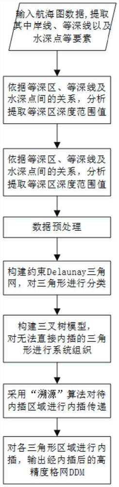
[0064] The high-precision digital water depth model construct proposed by the depth constraints proposed by the present invention, the implementation process is the construction of the computer to implement the high-precision digital water depth model of the navigation map, assume that the existing nautical map A, using the method of the present invention to build high Accuracy digital water depth model, including the following steps, such as figure 1 Looking:

[0065] S1: Enter nautical map data, extract the shoreline, the like deep lines (including the beach line), special lines (layers, forced cables, additional buffers, etc.) and water depth points and the water depths In memory, the collection of nautical map A in the hypothesis is referred to as S (L);

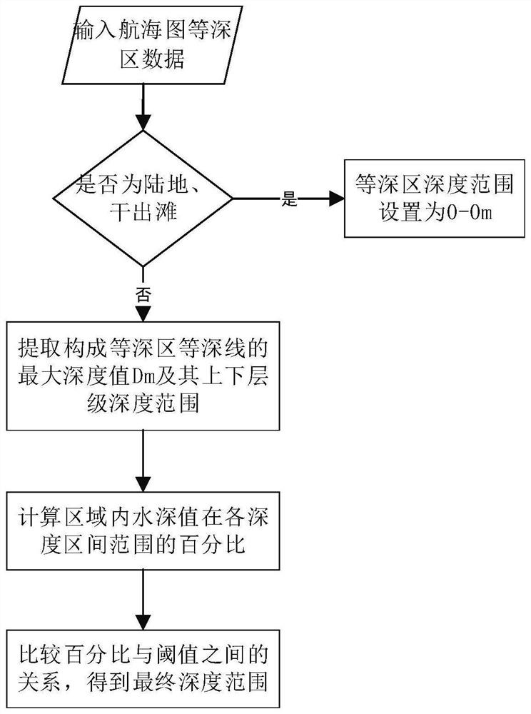
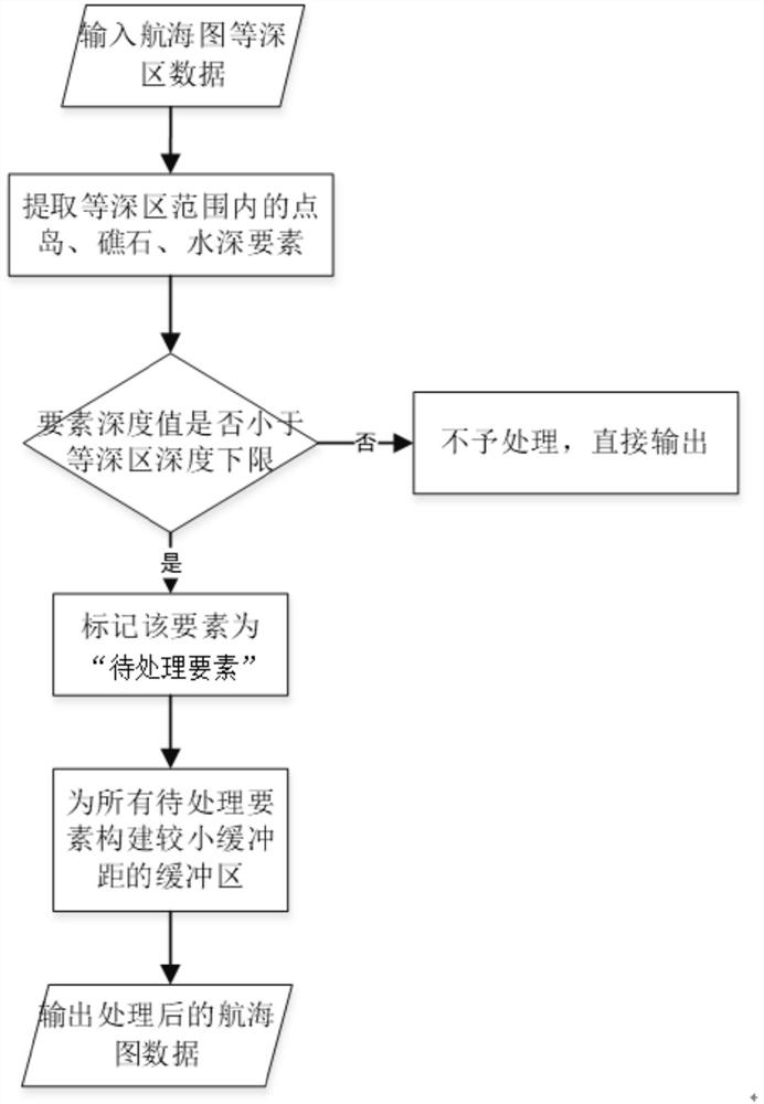
[0066] S2: According to the like in S (L), the relationship between the depth of the beach, the beach line, the beach ...


PUM


Abstract

The invention discloses a nautical chart high-precision digital water depth model construction method based on equal depth region constraint, and belongs to the technical field of marine surveying and mapping. According to the method, the high-precision digital water depth model conforming to the actual expression intention of the nautical chart is constructed by mainly aiming at the nautical chart data with relatively sparse water depth data and combining the elements such as the isobath, the shoreline and the hinders on the nautical chart; according to the method, the problem of obvious deviation between the local area depth value and the nautical chart expression intention caused by dense and sparse water depth is effectively solved, and the quality of the digital water depth model is remarkably improved.

Description

Technical field [0001] The present invention belongs to the field of marine surveying and mapping technology, involving a high-precision digital water depth model constructing such as a depth constraint. Background technique [0002] Digital Water Depth Models (DDM, DIGITAL DEPTH Model) are digitally expressed in the form of seabed surface through limited water depth data. An important application of DDM is the safe navigation of the ship's sea. Especially with the promotion of digital chart, DDM can be more accurate and reliably serve the ship navigation than traditional manual operation modes. [0003] In recent years, many scholars have conducted some exploration methods in different situations in different situations for a variety of sources of water depth data (including multi-beam-depth data, single-bundle water depth data, sea map water depth data, etc.). Among them, some methods are borrowed directly from DEM, introducing the interpolation of the high-profile value into t...

Claims


Application Information

Patent Timeline
Patent Type & Authority Applications(China)
IPC IPC(8): G06T17/20G06T17/00G06T17/05G06F30/10
CPCG06T17/20G06T17/005G06T17/05G06F30/10
Inventor 唐露露张立华董箭贾帅东魏泓丞
Owner PLA DALIAN NAVAL ACADEMY
Why Eureka
Try Eureka