
Projection geographic information GeoHash extension coding method

A technology for extended coding and geographic information, applied in the fields of uniform segmentation of geographic space-time information, fast coding and efficient retrieval, it can solve the problems of difficult to meet the needs of time-sensitive and distance-sensitive application scenarios, and achieve the goal of reducing the difficulty of numerical calculation and improving the distance. Effect

Active Publication Date: 2022-04-12
THE 724TH RES INST OF CHINA SHIPBUILDING IND
View PDF4 Cites 0 Cited by
  • Summary
  • Abstract
  • Description
  • Claims
  • Application Information

AI Technical Summary

Problems solved by technology

GeoHash does not uniformly include the target activity time into the coding range, and due to latitude changes, the geographical segmentation process is non-uniform, and the resulting division grid is non-uniform, which is difficult to meet the needs of time-sensitive and distance-sensitive application scenarios

Method used


Image

  • Projection geographic information GeoHash extension coding method
  • Projection geographic information GeoHash extension coding method
  • Projection geographic information GeoHash extension coding method

Examples


Embodiment Construction

[0023] The technical solutions of the present invention will be further explained below in conjunction with the accompanying drawings and embodiments.

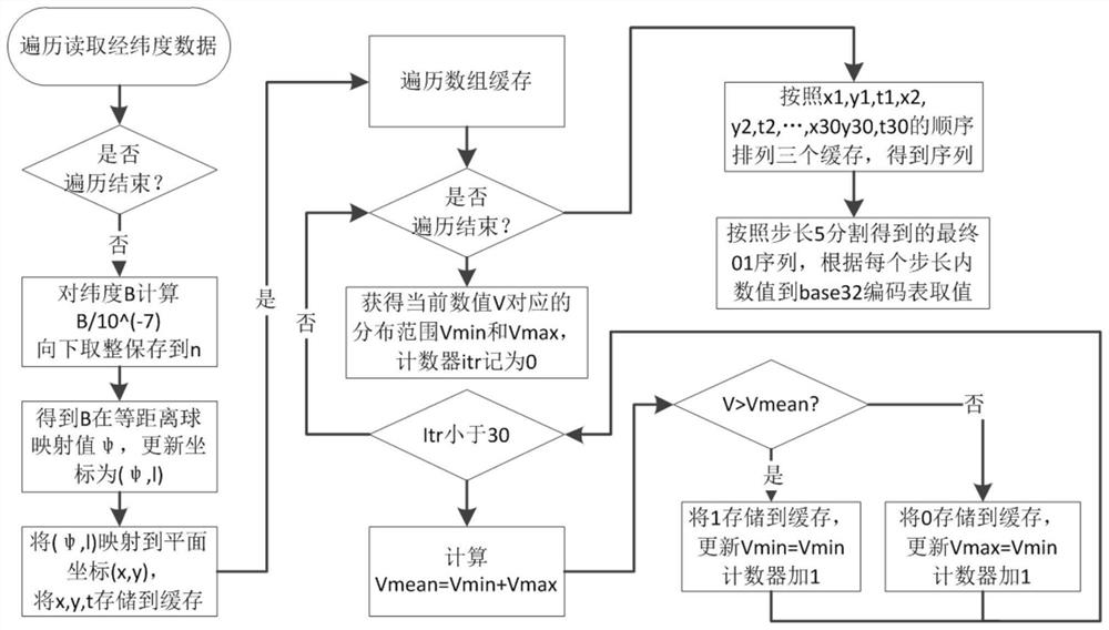
[0024] Step 1: Complete the offline calculation of the equidistant projection parameters of latitude and longitude. Assume that the spherical latitude ψ corresponding to the latitude value B in the interval [0,90] is calculated offline according to the step size of 0.0000001, and finally Φ={ψ i},i=0,1,...,90000000, the calculation formula is as follows:

[0025]

[0026]

[0027] r m =-exp(2log((2m-1)!!)-log(2m-1)-2mlog(2)-2log(m!)), m≥1

[0028]

[0029] where x 0 =B,r 0 =1. Compute offline at the same time:

[0030]

[0031] e 2 =(a 2 -b 2 ) / a 2

[0032] In the above formula, a=6387137 is the long radius of the earth, b=6356752 is the short radius of the earth, and e is the eccentricity.

[0033] Step 2: Arbitrary coordinates (B, l) on the ellipsoidal surface. Note n=B / 0.0000001 rounded, ψ n =sign(B...


PUM


Abstract

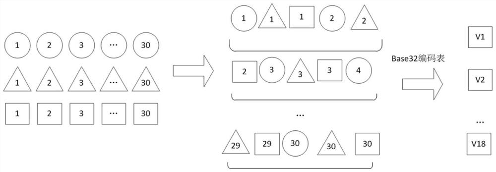
The invention provides a projection geographic information GeoHash extended coding method, which aims at the current situation that the existing GeoHash coding process method is non-uniform and does not bring time into coding, and comprises the following steps of: firstly, off-line mapping different latitude sampling points B to a dimension coordinate psi of a spherical surface according to a given step length epsilon, and storing the dimension coordinate psi as an intermediate vector value phi (n), n = 0, 1,..., ceil (90 / epsilon); secondly, for any point (B, l) on the ellipsoid surface, obtaining a mapping point (B, psi n) and psi n = sign (B) * phi (n) of the point (B, l) on the spherical surface, taking a negative value as a south latitude, and mapping the point (B, psi n) to a plane coordinate (x, y); (x, y, t) is processed again through the classical GeoHash recursive segmentation method, and when the time is processed, a sequence corresponding to the time is obtained through segmentation according to the specified starting time and ending time; and finally, three 0, 1 sequences corresponding to (x, y, t) are obtained through segmentation to complete the extended GeoHash coding. According to the method, the requirements of time and space sensitive geographic big data quick retrieval application scenes can be met.

Description

technical field [0001] The invention belongs to the technical field of geographic information, and relates to a method for uniform division, fast coding and high-efficiency retrieval of geographic space-time information. Background technique [0002] Geospatial data storage and management is the basic field of geographic information technology research and engineering application. With the rapid development of GIS technology, the wide application of maritime satellite, surveillance radar and telecommunication equipment technology has greatly improved the GIS data acquisition ability and transmission range. In recent years, the explosive growth of target activity time and space data represented by AIS data, navigation radar data, and Internet of Things data has posed a huge challenge to geospatial data cleaning, retrieval, matching and positioning. [0003] The classic GeoHash encoding method mainly divides the longitude and latitude coordinates through a limited number of re...

Claims


Application Information

Patent Timeline
IPC IPC(8): G06F16/9537G06F16/29G06F40/126
Inventor 赵鹏飞刘硕曹德建左锦波袁剑华
Owner THE 724TH RES INST OF CHINA SHIPBUILDING IND
Learn More