Supercharge Your Innovation With Domain-Expert AI Agents!

Consumer-level unmanned aerial vehicle photogrammetry flight stability evaluation method

A technology of photogrammetry and evaluation method, which is applied in photogrammetry/video metrology, radio wave measurement system, measurement device, etc. It can solve the problem of large difference in photography stability of wind resistance platform and achieve the effect of ensuring accuracy

Pending Publication Date: 2022-05-13
甘肃工业职业技术学院
View PDF0 Cites 0 Cited by
  • Summary
  • Abstract
  • Description
  • Claims
  • Application Information

AI Technical Summary

Problems solved by technology

[0003] At present, there are many brands and models of consumer drones on the market, and their wind resistance and platform photography stability are quite different.

Method used


Image

  • Consumer-level unmanned aerial vehicle photogrammetry flight stability evaluation method
  • Consumer-level unmanned aerial vehicle photogrammetry flight stability evaluation method
  • Consumer-level unmanned aerial vehicle photogrammetry flight stability evaluation method

Examples


Embodiment 1

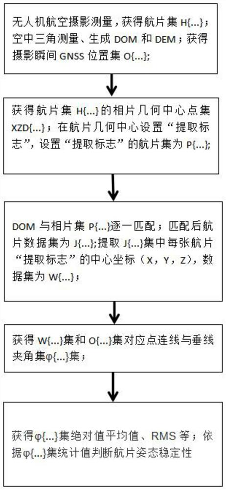
[0029] see figure 1 , {...} in the figure represents {1,2,3...n}, a consumer-grade UAV photogrammetry flight stability evaluation method, including the following steps:

[0030] S1. Use consumer-grade drones for aerial photogrammetry, and obtain the aerial photo set H{1,2,3...n}; aerial triangulation, generate digital orthophoto DOM and digital elevation model DEM, and obtain the moment of photography GNSS position set O{1,2,3...n}, wherein, n is the amount of aerial photo data, n≥10, and the GNSS position set O{1,2,3...n} at the moment of photography is the The location information (X, Y, Z) of the film set H{1,2,3...n} at the moment of photography.

[0031] S2. Obtain the photo geometric center point set XZD{1,2,3...n} of the aerial photo set H{1,2,3...n}; set the "extraction flag" at the photo geometric center point of the aerial photo, Set the aerial photo set of "extraction flag" as P{1,2,3...n}.

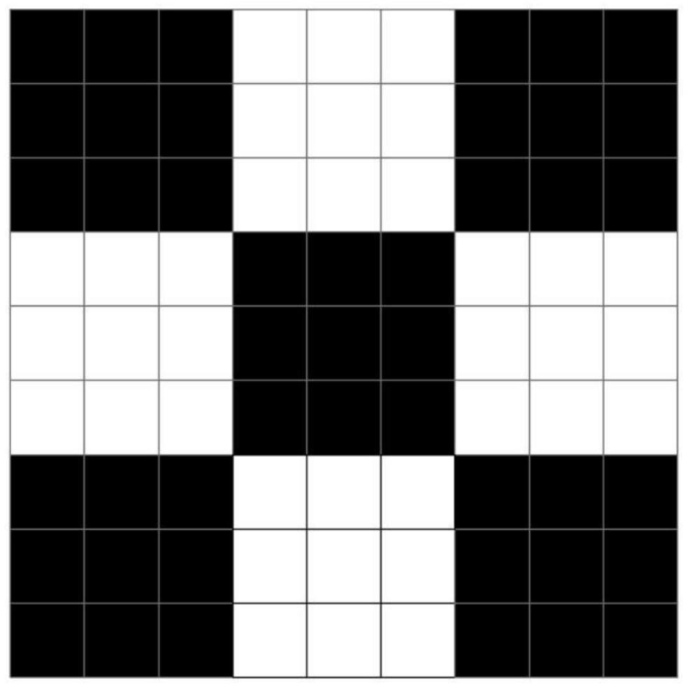
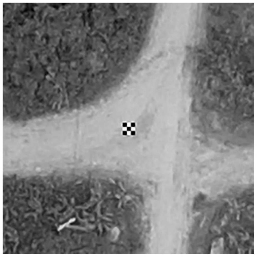
[0032] Further, the "extract flag" is as figure 2 As shown, there are...


PUM


Abstract

The invention discloses a consumer-level unmanned aerial vehicle photogrammetry flight stability evaluation method, and belongs to the technical field of photogrammetry. The method comprises the following steps: S1, obtaining an aerial photo set H {1, 2, 3... n}; carrying out aerial triangulation to generate a DOM and a DEM, and obtaining a GNSS position set O {...} at the moment of photography; s2, setting an aerial photo set of an extraction mark as P {...}; s3, the set P {...} is J {...} after being matched with the DOM, center point coordinate information of an extraction mark of each aerial photo in the J {...} set is obtained, and a data set is W {...}; s4, obtaining an included angle set phi {1, 2, 3. N} set of a connecting line of corresponding points and a vertical line; and S5, judging the attitude stability of the aerial photo according to the statistical data of the phi {1, 2, 3. N} set. The attitude stability of different types of unmanned aerial vehicles at the photographing moment is evaluated, so that the precision of aerial photogrammetry is ensured.

Description

technical field [0001] The invention belongs to the technical field of photogrammetry, and in particular relates to a method for evaluating flight stability of a consumer-grade unmanned aerial vehicle photogrammetry. Background technique [0002] In recent years, the rapid development of UAV photogrammetry technology has greatly promoted the transformation of surveying and mapping geographic information technology and industrial development. However, in the field of photogrammetry technology, there are still some technical phenomena such as unmanned aerial vehicles that are not equipped with aerial camera gyro stabilization devices, or the unmanned aerial vehicle itself has poor flight attitude stability and wind resistance. This technical phenomenon leads to unstable photography attitude of UAV at the moment of aerial photography, and problems such as excessive tilt angle of aerial photography, which have a great impact on the accuracy of aerial photogrammetry. At present,...

Claims


Application Information

Patent Timeline
IPC IPC(8): G01C11/00G01S19/06G01C25/00
CPCG01C11/00G01S19/06G01C25/00Y02T10/40
Inventor 王利军
Owner 甘肃工业职业技术学院
Features
  • R&D
  • Intellectual Property
  • Life Sciences
  • Materials
  • Tech Scout
  • Unparalleled Data Quality
  • Higher Quality Content
  • 60% Fewer Hallucinations
Learn More