Multi-unmanned aerial vehicle coverage path planning method for three-dimensional reconstruction

A technology covering paths and multi-UAVs, applied in the field of UAVs, can solve the problems of optimizing the energy consumption of UAV groups, and achieve the effects of reduced flight time consumption, effective data collection, and reduced path length

Pending Publication Date: 2022-05-13
SUN YAT SEN UNIV +1
View PDF8 Cites 0 Cited by
  • Summary
  • Abstract
  • Description
  • Claims
  • Application Information

AI Technical Summary

Problems solved by technology

The regional decomposition and path form of the existing research in the single-target area are still highly dependent on the shape of the area boundary, which leads to the optimization of energy consumption of only some UAVs and cannot optimize the energy consumption of the UAV group as a whole.

Method used


Image

  • Multi-unmanned aerial vehicle coverage path planning method for three-dimensional reconstruction
  • Multi-unmanned aerial vehicle coverage path planning method for three-dimensional reconstruction
  • Multi-unmanned aerial vehicle coverage path planning method for three-dimensional reconstruction

Examples


Embodiment Construction

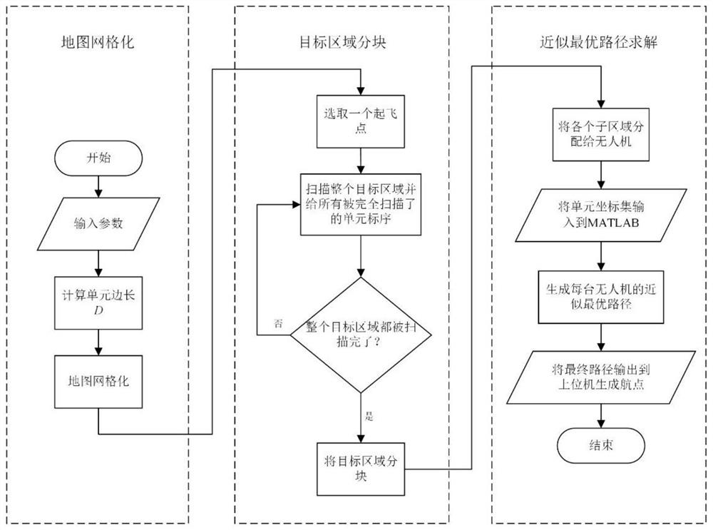
[0047] The present invention will be further described in detail below in conjunction with the accompanying drawings and specific embodiments. For the step numbers in the following embodiments, it is only set for the convenience of illustration and description, and the order between the steps is not limited in any way. The execution order of each step in the embodiments can be adapted according to the understanding of those skilled in the art sexual adjustment.

[0048] Such as figure 1 As shown, the present invention provides a method for multi-UAV coverage path planning oriented to three-dimensional reconstruction, the method comprising the following steps:

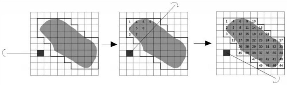
[0049] S1. Obtain the target area and perform grid segmentation on the target area to obtain a grid map;

[0050] S1.1. Determine the target area according to user needs;

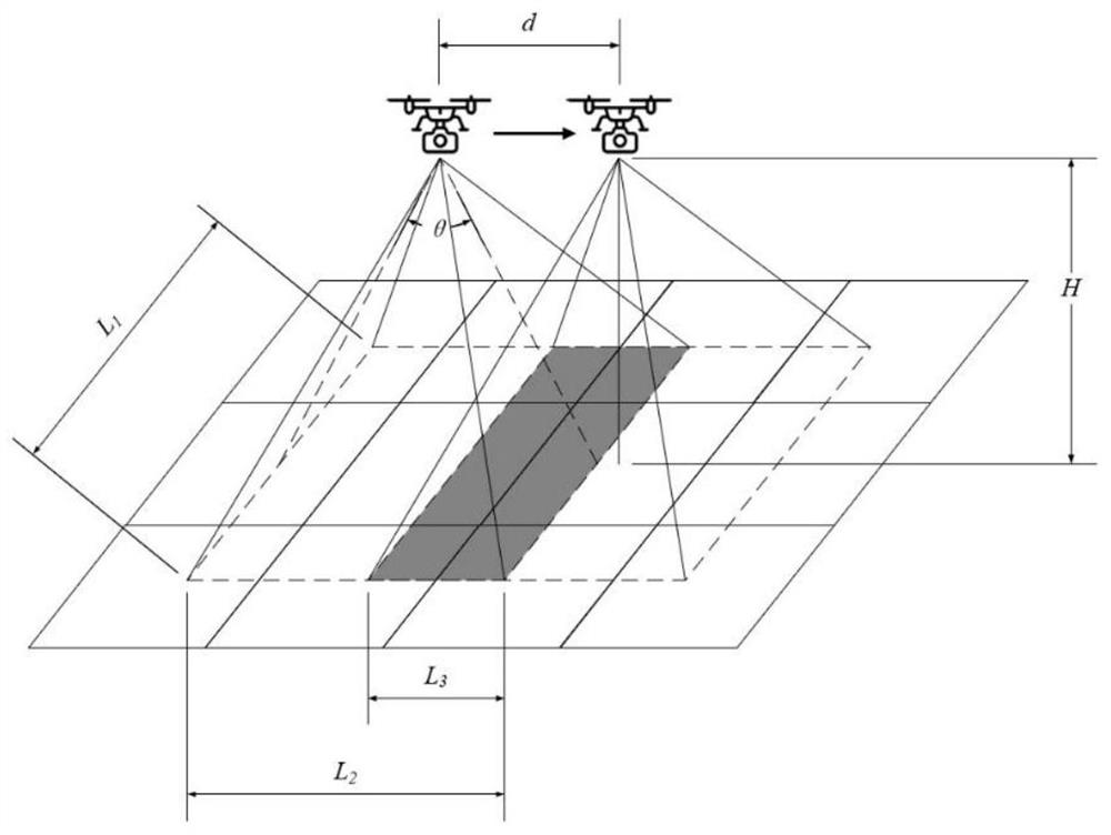
[0051] S1.2. Calculate the picture overlap according to the flying height of the drone, the distance between the shooting points and the field of...


PUM


Abstract

The invention discloses a multi-unmanned aerial vehicle coverage path planning method for three-dimensional reconstruction, and the method comprises the steps: obtaining a target region, carrying out the grid segmentation of the target region, and obtaining a grid map; calculating the side length of a cell in the gridding map and determining the coverage path of the unmanned aerial vehicle; processing the gridding map based on an area partitioning method of cell scanning to obtain equal sub-areas; and solving an approximate optimal path in the equal sub-region based on an approximate optimal path planning method, and guiding the unmanned aerial vehicle to fly. According to the invention, the image acquisition efficiency can be improved while the energy consumption of the unmanned aerial vehicle is reduced. The multi-unmanned aerial vehicle coverage path planning method for three-dimensional reconstruction can be widely applied to the technical field of unmanned aerial vehicles.

Description

technical field [0001] The invention relates to the technical field of unmanned aerial vehicles, in particular to a multi-unmanned aerial vehicle coverage path planning method oriented to three-dimensional reconstruction. Background technique [0002] With the continuous development of modern control technology, the application of drones is becoming more and more extensive. In tasks such as target search and area detection, UAVs carry sensors and conduct full-coverage reconnaissance of target areas. In a large target area, due to the weak battery life of existing commercial drones, the work efficiency of a single drone and the amount of tasks that can be completed in a single flight are relatively limited, and multiple drones are required to perform Task. For example, in the ocean zone scientific research, a large-scale regional detection task requires the cooperation of multiple drones. The regional decomposition and path form of the existing research in the single-targe...

Claims


Application Information

Patent Timeline
Patent Type & Authority Applications(China)
IPC IPC(8): G05D1/12
CPCG05D1/12
Inventor 谭晓军张乐天肖司辰吴加学任杰
Owner SUN YAT SEN UNIV
Why Eureka
Try Eureka