Road scene recognition method and device

A scene recognition and road technology, applied in the field of satellite navigation, can solve the problem of inability to distinguish vehicles driving on an elevated, inability to output scene recognition, etc., so as to reduce the influence of interference factors on the results, reduce misrecognition, and improve accuracy. rate effect

Pending Publication Date: 2022-05-13
QIANXUN SPATIAL INTELLIGENCE INC
View PDF0 Cites 1 Cited by
  • Summary
  • Abstract
  • Description
  • Claims
  • Application Information

AI Technical Summary

Problems solved by technology

[0003] Existing technologies often only perform scene recognition for a single image, that is, for a certain picture, one or several scenes are obtained through the method of deep learning feature extraction, but for lane-level navigation, etc., the positioning scene

Method used


Image

  • Road scene recognition method and device
  • Road scene recognition method and device
  • Road scene recognition method and device

Examples


Example Embodiment

[0044] In the following description, numerous technical details are set forth in order to provide the reader with a better understanding of the present application. However, those of ordinary skill in the art can understand that even without these technical details and various changes and modifications based on the following embodiments, the technical solutions claimed in the present application can be realized.

[0045] Explanation of some concepts:
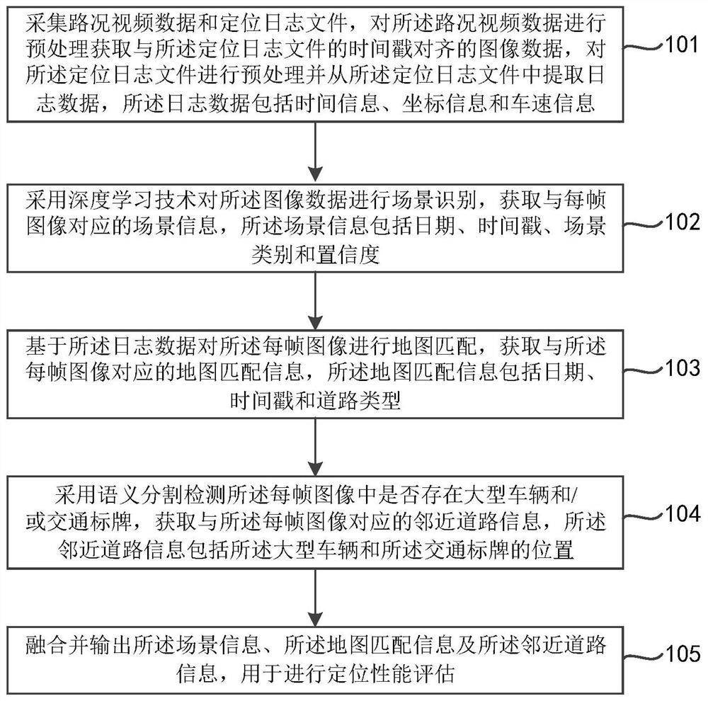
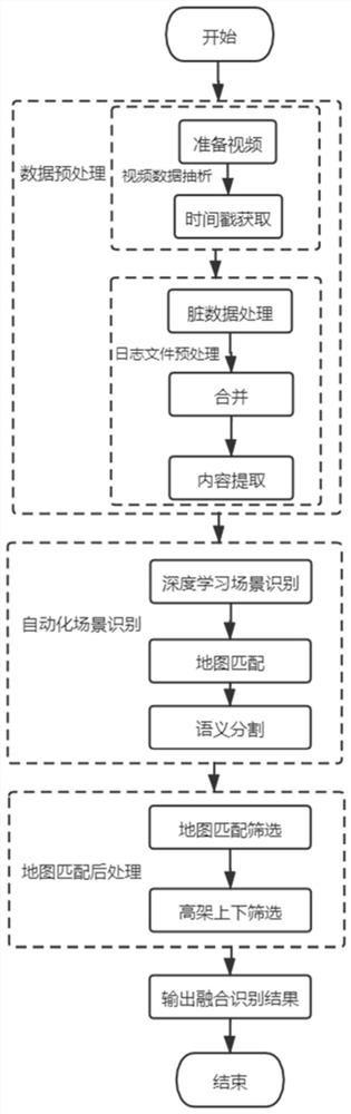
[0046] Map matching technology: The process of associating the vehicle's position information with the road network of the electronic map, and converting the coordinate downsampling sequence into the road network coordinate sequence to obtain the current road type.

[0047] Image Semantic Segmentation Technology: Label the category of each pixel in the image, and divide the image into several regions with similar properties to achieve the effect of classification.

[0048] In order to make the objectives, technical solutions and ...


PUM


Abstract

The invention relates to the technical field of satellite navigation, and discloses a road scene recognition method and device, and the method comprises the steps: collecting road condition video data and a positioning log file, carrying out the preprocessing of the road condition video data, and obtaining image data aligned with the timestamp of the positioning log file, preprocessing the positioning log file and extracting log data; performing scene recognition on the image data by adopting a deep learning technology, and obtaining scene information corresponding to each frame of image, including date, timestamp, scene category and confidence; map matching is carried out on each frame of image based on the log data, and map matching information corresponding to each frame of image is obtained and comprises dates, timestamps and road types; semantic segmentation is adopted to detect whether a large vehicle and/or a traffic sign exist in each frame of image, and adjacent road information is acquired, wherein the adjacent road information comprises the positions of the large vehicle and the traffic sign; and fusing and outputting the scene information, the map matching information and the adjacent road information for performing positioning performance evaluation.

Description

technical field [0001] The present application relates to the technical field of satellite navigation, in particular to a road scene recognition method and device thereof. Background technique [0002] At present, in evaluating the high-precision positioning performance of autonomous driving scenarios, it has become an important topic to be able to accurately analyze different usage scenarios and match different indicators. The traditional method is to use satellite information to judge the use scene, such as the number of satellites and the altitude angle. This can achieve a certain purpose of distinction, but since the distribution of satellites at different time points cannot be determined and unified, different scenes cannot be intuitively distinguished. Another solution is to determine an entire road section as the same scene. But this is obviously not in line with the actual situation, and the actual situation on a road scene will be much more complicated. Therefore...

Claims


Application Information

Patent Timeline
IPC IPC(8): G06V20/52G06V20/40G06V20/13G06V10/80G06K9/62G06F16/18G06F16/29
CPCG06F16/1815G06F16/29G06F18/25
Inventor 鲍世哲
Owner QIANXUN SPATIAL INTELLIGENCE INC
Why Eureka
Try Eureka