Smart city 3D map model photography establishment method based on unmanned aerial vehicle technology

A technology of map model and establishment method, which is applied in the field of photography establishment of 3D map model of smart city, can solve the problems of real picture quality, inconsistent imaging scale, and lack of photography that affect buildings, so as to achieve flexible intelligent control and comprehensive High-quality imaging, effects that meet the needs of generation

Active Publication Date: 2022-06-24
重庆尚优科技有限公司
View PDF2 Cites 2 Cited by
  • Summary
  • Abstract
  • Description
  • Claims
  • Application Information

AI Technical Summary

Problems solved by technology

[0003] As we all know, the acquisition of a real-scene map first needs to obtain a real-scene picture through photography, and then generate a real-scene map. However, in many classifications of real-scene maps, due to the large shape of the building itself, the real scene of the building cannot be photographed manually. , can only be generated by aerial photography with drones, and the quality of aerial photography directly affects the generation effect of real-world maps of buildings. In this case, the quality of aerial photography of drones has become the focus of attention in generating 3D maps of urban buildings
[0004] However, in the prior art, during the aerial photography of the buildings in the area to be photographed by the UAV, on the one hand, the photography mode it adopts is single, so that the real picture of the building can only reflect a single perspective, resulting in the real scene imaging effect of the building. It is relatively one-sided, which reduces the visual effect of real-scene pictures to a certain extent; on the other hand, due to the lack of accurate and reliable selection basis for the selection of the corresponding shooting position of the building by the UAV, the selection of the shooting position is too random, resulting in the building Real-scene pictures often have imaging defects, such as incongruous imaging ratios, unphotographed areas, etc., which affect the quality of real-scene pictures of buildings, making it difficult to meet the needs of generating 3D maps of urban buildings

Method used


Image

  • Smart city 3D map model photography establishment method based on unmanned aerial vehicle technology
  • Smart city 3D map model photography establishment method based on unmanned aerial vehicle technology

Examples


Embodiment Construction

[0057] The technical solutions in the embodiments of the present invention will be clearly and completely described below with reference to the accompanying drawings in the embodiments of the present invention. Obviously, the described embodiments are only a part of the embodiments of the present invention, but not all of the embodiments. Based on the embodiments of the present invention, all other embodiments obtained by those of ordinary skill in the art without creative efforts shall fall within the protection scope of the present invention.

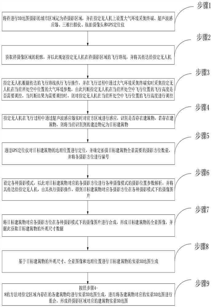
[0058] refer to figure 1 As shown, the present invention provides a method for photographing a 3D map model of a smart city based on UAV technology, comprising the following steps:

[0059] Step 1: Record the urban area to be photographed for 3D map as the area to be photographed, and set up the atmospheric environment collection terminal, ultrasonic sensor, 3D scanner, aerial camera and GPS locator on the designated drone, among whic...


PUM


Abstract

The invention discloses a smart city 3D map model photographing establishment method based on an unmanned aerial vehicle technology, and the method comprises the steps: setting various photographing modes in a process of carrying out the aerial photographing of a building in a to-be-photographed region through an unmanned aerial vehicle; and an accurate and reliable photographing position parameter analysis mode is provided for various photographing modes based on the boundary dimension of the to-be-photographed building, so that the real scene picture of the to-be-photographed building obtained under the various photographing modes and the corresponding photographing position parameters can reflect a plurality of visual angles and can present a full view. According to the method, comprehensive high-quality imaging of the building real scene is realized, the defects of building real scene aerial photography caused by too single photography mode and too random photography position selection in the prior art are effectively overcome, on one hand, the quality of the building real scene picture is improved, and on the other hand, the visual effect of building real scene imaging is improved; and the generation requirement of the urban building 3D map is greatly met.

Description

technical field [0001] The invention belongs to the technical field of city map establishment, in particular to a method for photographing and establishing a 3D map model of a smart city based on unmanned aerial vehicle technology. Background technique [0002] Urban planning is a series of arrangements made by the municipal government for comprehensive basic data such as the natural characteristics, development status, resource structure, regional location, and historical conditions of the city. People are more and more aware of the importance of urban planning and management, and the first step in urban planning is to obtain a real map of the area to be planned, which is divided into road real map, vegetation real map and building real map. [0003] As we all know, the acquisition of a real map needs to first obtain a real image through photography, and then generate a real map. In many real map classifications, because the shape of the building itself is relatively large,...

Claims


Application Information

Patent Timeline
IPC IPC(8): G01C11/00G06T17/00
CPCG01C11/00G06T17/00
Inventor 罗顺王利刘宁韩建李睿之王新仁周鹏耀方超冯莉莎郑国平
Owner 重庆尚优科技有限公司
Why Eureka
Try Eureka