Waypoint navigation

a technology for remote control and unmanned aerial vehicles, applied in the direction of process and machine control, distance measurement, instruments, etc., can solve the problems of uncontrollable crashing of unmanned aerial vehicles, remains to be solved, and cannot be returned to the present location

Active Publication Date: 2004-09-30
SAAB AB
View PDF11 Cites 184 Cited by
  • Summary
  • Abstract
  • Description
  • Claims
  • Application Information

AI Technical Summary

Problems solved by technology

However, the problem of preventing a UAV from crashing uncontrollably during a time period when the radio contact is broken remains to be solved.
Namely, basically at any time, a critical fault condition may arise in the UAV, which renders all return routes from the vehicle's present location impossible, and instead forces the UAV to perform a relatively speedy landing operation.
Naturally, if such a landing...

Method used


Image

  • Waypoint navigation
  • Waypoint navigation
  • Waypoint navigation

Examples


Embodiment Construction

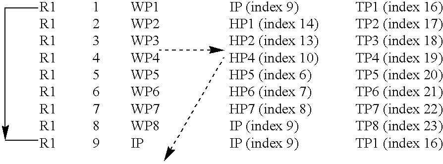
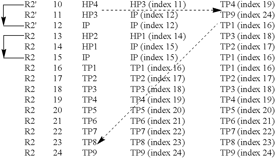
[0033] FIG. 1 illustrates the proposed method of controlling an unmanned aerial vehicle 100 by means of an exemplary primary route R1 / R1' and an exemplary emergency route R2'. A control station 110 controls the vehicle 100 by means of a wireless command link 115. Preferably, at least in a military application and where the control station 110 is ground based, it should be geographically separated from a base station transceiver 120, which serves the command link 115. Namely thereby, the control station's 110 position cannot be determined on basis of the traffic over the command link 115. However, if the control station 110 is mobile, for instance positioned in another aircraft, it is generally preferable to co-locate it with the base station transceiver 120 for practical reasons.

[0034] It is presumed that the vehicle 100 takes off from a runway at a base location 130, which preferably is located relatively proximate to the control station 110 (provided that this type of control stat...


PUM


Abstract

The invention relates to remote control of an unmanned aerial vehicle, UAV, (100) from a control station (110) by means of a wireless command link (115). The UAV (100) may be controlled in an autonomous mode wherein it flies according to a primary route (R1, R1') defined by a first set of predefined waypoints (WP1-WP8, IP). The UAV (100) may also be controlled in a manual mode wherein it flies according to an alternative primary route (R1') defined in real-time by control commands received via the wireless command link (115). Flight control parameters are monitored in both modes, and in case a major alarm condition occurs, the UAV (100) is controlled to follow an emergency route (R2') defined by a second set of predefined waypoints (HP1-HP7, TP1-TP9, IP). Particularly, a major alarm condition is activated if an engine failure is detected. Then, the emergency route (R2') involves flying the UAV (100) to an air space above a termination waypoint (TP9) on the ground at which it is estimated that the vehicle's (100) flight may be ended without injuring any personnel or causing uncontrolled material damages.

Description

THE BACKGROUND OF THE INVENTION AND PRIOR ART[0001] The present invention relates generally to remote control of unmanned aerial vehicles. More particularly the invention relates to a method according to the preamble of claim 1, a computer program according to claim 13, a computer readable medium according to claim 14 and an unmanned aerial vehicle according to the preamble of claim 15.[0002] Remotely controlled unmanned aerial vehicles (UAV:s) represent an increasingly important field of aircraft technology, particularly for the military sector. UAV:s may namely be used to perform a large variety of military operations, such as reconnaissance flight and target combating. Therefore, the prior art includes various examples of solutions for controlling a UAV. For instance, the U.S. Pat. No. 6,377,875 describes a method for controlling a UAV wherein upon loss of radio contact between a control station and the UAV, the UAV flies according to a pre-programmed safety route. During any int...

Claims


Application Information

Patent Timeline
IPC IPC(8): G05D1/00G05D1/02
CPCG05D1/0022G05D1/105G05D1/0202G05D1/106
Inventor CARLSSON, CARL-OLOFADEBJORK, PETER
Owner SAAB AB
Why Eureka
Try Eureka